RBSE Solutions for Class 9 Social Science Geography Chapter 4 Climate
Rajasthan Board RBSE Solutions for Class 9 Social Science Geography Chapter 4 Climate Textbook Exercise Questions and Answers.
Rajasthan Board RBSE Solutions for Class 9 Social Science in Hindi Medium & English Medium are part of RBSE Solutions for Class 9. Students can also read RBSE Class 9 Social Science Important Questions for exam preparation. Students can also go through RBSE Class 9 Social Science Notes to understand and remember the concepts easily. The india size and location important questions are curated with the aim of boosting confidence among students.
RBSE Class 9 Social Science Solutions Geography Chapter 4 Climate
RBSE Class 9 Social Science Climate InText Questions and Answers
Page No. 27
Question 1.
Why the houses in Rajasthan have thick walls and flat roofs?
Answer:
(i) In the desert areas of Rajasthan, it is very hot during summer and cold during the winters. The thick mud walls of the houses act as insulators. In summers, these walls do not allow the outside heat to penetrate into the houses, thus keeping them cool inside. On the other hand, these walls trap the inside heat, and keep the houses warm in winters.
(ii) Also, Rajasthan is an arid region and does not receive much rainfall. Therefore the flat roofs help to retain the little water that has been collected during rainfall.

Question 2.
Why is it that the houses in the Tarai region and in Goa and Mangalore have sloping roofs?
Answer:
The Tarai region, Goa and Mangalore receive heavy rainfall during the monsoon season. The houses in these regions have sloping roofs because these allow rainwater flow off the roof instead of accumulating on the roof.
Question 3.
Why houses in Assam are built on stilts?
Answer:
Assam receives very heavy rainfall which causes flood in the low lying areas. Since, the stilt houses are some feet above the ground, they prevent flooding of houses.
Question 4.
Why most of the world’s deserts are located in the western margins of continents in the subtropics?
Answer:
Most of the world’s deserts are located in the western margins of the continents in the subtropics because of the following reasons:
(i) Offshore Trade Winds : In this region the trade winds blow in the North easterly direction in the northern hemisphere, and in the South Easterly direction in the southern hemisphere. As such they are onshore (blowing from sea to land) when they first hit the east coast, they lose much of their moisture. By the time these winds reach the western margins, they become offshore (blowing from land to sea) and hence become very dry with little possibility of causing precipitation.
(ii) Cold Oceanic Currents: The presence of cold ocean currents along the western
shores of continents is one of the main reasons for the location of deserts along the western margins. The air blowing over the cold ocean currents is cold and dry and hence causes no/ little precipitation.
RBSE Class 9 Social Science Climate Textbook Questions and Answers
Question 1.
Choose the correct answer from the four alternatives given below.
(i) Which one of the following places receives the highest rainfall in the world?
(a) Silchar
(b) Mawsynram
(c) Cherrapunji
(d) Guwahati
Answer:
(b) Mawsynram
(ii) The wind blowing in the northern plains in summers is known as:
(a) Kaal Baisakhi
(b) Loo
(c) Trade Winds
(d) None of the above
Answer:
(b) Loo
(iii) Which one of the following causes rainfall during winters in north-western part of India.
(a) Cyclonic depressionances
(b) Retreating monsoon
(c) Western disturbances
(d) Southwest monsoon
Answer:
(a) Cyclonic depression
(iv) Monsoon arrives in India approximately in:
(a) Early May
(b) Early July
(c) Early June
(d) Early August
Answer:
(c) Early June
(v) Which one of the following characterises the cold weather season in India?
(a) Warm days and warm nights
(b) Warm days and cold nights
(c) Cool days and cold nights
(d) Cold days and warm nights
Answer:
(b) Warm days and cold nights
Question 2.
Answer the following questions briefly.
(i) What are the controls affecting the climate of India?
Answer:
Latitude, altitude, pressure and wind system, distance from the sea, continentality, ocean currents and relief features are the controls affecting the climate of India.
(ii) Why does India have a monsoon type of climate?
Answer:
India has a monsoon type of climate because its climate is strongly influenced by monsoon winds.
(iii) Which part of India does experience the highest diurnal range of temperature and why?
Answer:
The Great Indian Desert located in the northwestern part of India experiences ' the highest diurnal range of temperature because this region has low vegetation cover and the land is covered with sand. Sand absorbs heat quickly during the day and loses heat very quickly at night. As a result, there is a day temperature may rise to 50°C and drop down to nearly 15°C the same night. It is also away from the sea.Thus, there is a wide difference between day and night temperatures in this region.
(iv) Which winds account for rainfall along the Malabar coast?
Answer:
The Malabar Coast receives rainfall from the South West monsoon winds.
(v) What are Jet streams and how do they affect the climate of India?
Answer:
1. The Jet Streams are a narrow belt of high altitude westerly winds in the upper troposphere. Their speed varies from about 110 km/h in summer and about 184 km/h in winter. A number of separate jet streams have been identified. The most constant are the mid-latitude and the sub-tropical jet stream. These jet streams are located approximately over 27° - 30° north latitude, therefore they are known as subtropical westerly jet stream.
2. Over India, these jet stream blow south of the Himalayas, all through the year except in Summer. The western cyclonic disturbances experienced in the north and north western part of the country are brought in by this western flow. In summer, the subtropical westerly jet stream moves nortji of the Himalayas with the apparent movement of the Sun.
3. An easterly jet stream, called the sub-tropical easterly jet stream blows over peninsular India, approximately over 14°N during the summer months.
(vi) Define monsoons. What do you understand by “break” in monsoon?
Answer:
The word monsoon is derived from the Arabic word ‘Mausim’ which literally means season. A monsoon is a seasonal reversal in the wind direction during a year, that usually brings with it a different kind of weather. Monsoons can be experienced in the region of South and Southeast Asia. Rain does not fall continuously during the monsoon season.
There are wet and dry spells, that is, the monsoon rains take place only for a few days at a . time and then the weather becomes suddenly drier. Such dry spells when the monsoon activity becomes low or almost nil are known as ‘breaks; in monsoon. These are caused by the shifting of the monsoon trough.
(vii) Why is the monsoon considered a unifying bond?
Answer:
- The unifying influence of the monsoon on the Indian subcontinent is quite perceptible. The seasonal alteration of the wind systems and the associated weather conditions provide a rhythmic cycle of seasons. Even the uncertainties of rain and uneven distribution are very much typical of the monsoons.
- The Indian landscape, its animal and plant life, its entire agricultural calender and the life of the people, including their festivities, revolve around this phenomenon.
- People of India, from north to south and from e&st to west, eagerly await the arrival of the monsoon.
- These monsoon winds bind the whole country by providing water to set the agricultural activities in motion. The river valleys which carry this water
- also unite as a single river valley unit. .
Question 3.
Why does the rainfall decrease from the east to the west in Northern India?.
Answer:
(i) Both eastern and western parts of northern India receive rainfall from the bay of Bengal branch of monsoon. But there is less rainfall in west region of Northern India because of the continuous decrease in the humidity of the winds.
(ii) As the Bay of Bengal branch of the southeast monsoon first reaches the eastern part and (causes) heavy rainfall as compared to the western part. Besides this, the western part has a distance from the sea so the winds are drier.
Question 4.
Give reasons as to why.
(i) Seasonal reversal of wind direction takes place over the Indian subcontinent?
(ii) The bulk of rainfall in India is concentrated over a few months.
(iii) The Tamil Nadu coast receives winter rainfall.
(iv) The delta region of the eastern coast is frequently struck by cyclones.
(v) Parts of Rajasthan, Gujarat and the leeward side of the Western Ghats are drought-prone.
Answer:
(i) India lies in the region of north easterly wind. These winds originate from the subtropical high-pressure belt of the northern hemisphere. They blow southwards, get deflected to the right due to the coriolis force, and move towards the equatorial low-pressure area The coriolis force is responsible for deflecting winds towards the right in the northern hemisphere and towards the left in the southern hemisphere.
(ii) By early June, the low pressure condition over the northern plains intensifies. It attracts the trade winds of the southern hemisphere. These south-east trade winds originate over the warm subtropical areas of the southern oceans were: They cross the equator and blow in a south-westerly direction entering the Indian peninsula as the south-west monsoon. As these winds blow over warm oceans, they bring abundant moisture to the subcontinent.
These winds are strong and blow at an average velocity of 30 km per hour. With the exception of the extreme north-west, the monsoon winds cover the country in about a month. The inflow of the south-west monsoon into India bring about a total change in the weather. The maximum rainfall of this season is received in the north-eastern part of the country. Another phenomenon associated with the monsoon is its tendency to have breaks in rainfall.
Thus it has wet and dry spells. For various reasons, the trough and its axis keep on moving northward, which determines the spatial distribution of rainfall. The frequency and intensity of tropical depression also determine the amount and duration of monsoon rains. The duration of the monsoon is between 100 to 120 days. Hence the bulk of rainfall received by the country is concentrated over a few month.
(iii) During the cold weather season, the northeast trade winds prevail over the country. These offshore winds blow from land to sea, and therefore bring little or no rain. However, before entering Tamil Nadu these winds blow over the Bay of Bengal and are laden with moisture. When these enter the land, the Eastern Ghats act as a barrier which causes winter rainfall in the Tamil Nadu coast.
(iv) By the early November, the low-pressure conditions prevailing over northwestern India move to the Bay of Bengal and causes cyclonic depressions to develop over the Andaman Sea. These cyclonic depressions are brought in by the sub-tropical easterly jet stream blowing over peninsular India during the monsoon as well as during October to November period. Due to this, the delta region of the eastern coast of India is frequently struck by cyclones.
(v) Parts of Rajasthan and Gujarat are drought-prone because these regions receive scanty rainfall during the monsoon rains as the winds of the Bay of B engal branch lose much of their moisture by the time they get to these areas. Also, the height of the Aravalli Range is not high enough to block the rain bearing clouds and cause rain in this region. The leeward side of the Western Ghats gets scanty rainfall as it is the rain-shadow area, and receives very little rainfall from the Arabian Sea branch. Hence, this region is also drought-prone.
Question 5.
Describe the regional variations in the climatic conditions of India with the help of suitable examples.
Answer:
There is great regional variations in the climatic conditions of India and precipitation varies from place to place and season to season.
(i) Temperature Variations:
(a) Temperatures varies across different places in different seasons.Example: In summer, temperatures in some parts of the Rajasthan desert may rise up to 50°C, whereas it may be around 20°C in Pahalgam in Jammu and Kashmir. In winters, the night temperature at Drass in Jammu and Kashmir may be-45°C, while on the same night Tiruvananthapuram may have a temperature of 22°C.
(b) Certain regions such as the Thar Desert experience very high diurnal range of temperature, where the day temperature may rise to 50°C, and drop down to near 15°C the same night. However, the diurnal range of temperature is very low in many parts of India such as Andaman and Nicobar islands and Kerala, where there is hardly any difference in day and night temperatures.
(c) The coastal areas experience less contrasts in the seasonal temperature conditions, while the seasonal contrasts are more in the interior of the country.
(ii) Precipitation Variations:
(a) India experiences variations in the form of precipitation. In the upper parts of Himalayas the precipitation is mostly in the form of snowfall, whereas, the rest of the country gets precipitation in the form of rain.
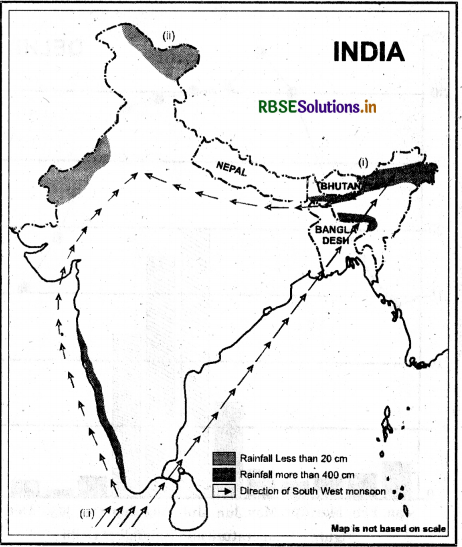
(b) The amount of rainfall distribution varies throughout India. There is a decrease in rainfall generally from east to west in the Northern Plains
(c) The range of annual precipitation greatly varies throughout the country. While the western coast and northeastern India receive over 400 cm of rainfall annually, it is less than 10 cm in Ladakh and western Rajasthan.
Question 6.
Discuss the mechanism of monsoons.
Answer:
The monsoons are experienced in the tropical area roughly between 20°N and 20° S. To understand the mechanism of the monsoon, the following facts are important.
(i) The differential heating and cooling of land and water creates low pressure on the landmass of India. While the seas around experience comparatively high pressure.
(ii) The shift of the position of Inter Tropical Convergence.Zone (ITCZ) in summer, over the Ganga plain.
(iii) The presence of the high-pressure area, east of Madagascar, approximately at 20°S over the Indian Ocean. The intensity and position of tarea affects the Indian Monsoon.
(iv) The tibetan plateau gets intensely heated, during summer, which results in strong vertical air currents and the formation of low pressure over the plateau at about 9 km above sea level.
(v) The movement of the westerly jet stream to the north of the Himalayas and the presence of the tropical easterly j et stream over the Indian peninsula during summer.
(vi) Changes in pressure conditions over the Southern Oceans also affect the monsoons. When the tropical eastern south Pacific Ocean experiences high pressure, the tropical eastern Indian Ocean experiences low pressure.
(vii) In certain years, there is reversal in the pressure conditions and the eastern pacific has lower pressure in comparision to the eastern Indian Ocean. This periodic change in pressure conditions is known as the Southern Oscillation or SO. The difference in pressure over Tahiti and Darwin in northern Australia is computed to predict the intensity of monsoon.
(viii) If the pressure differences were negative, it would mean below average or late monsoon. A feature connected with the SO is El Nino phenomenon in which a warm ocean current that flows past the Peruvian coast, in place of the cold. Peruvian current, every 2 to 5 years. The changes in Pressure conditions are connected to El Nino. Hence, the phenomenon is referred as ESNO.
Question 7.
Give an account of weather conditions and characteristics of the cold season.
Answer:
The weather conditions and characteristics of the cold season are as follows :
- The cold weather season begins from mid-November in northern India and stays till February.
- December and January are the coldest months in the northern part of India. The temperature decreases from south to the north of India.
- Days are warm and nights Eire cold. Frost is common in the north and the higher slopes of the Hiinalayas experience snowfall.
- During this season, the northeast trade winds prevEul over the country. They blow from land to sea and hence, the cold season in most parts of the country is the dry season.
- In the northern part of the country, a feeble high pressure region develops, with light winds moving outwards from this area.
- Influenced by the relief, these winds blow through the Ganga valley from the west Eind the northwest. The weather is normally marked by clear sky, low temperatures and low humidity and feeble, variable winds.
- A characteristic feature of the cold weather season over the northern plains is the inflow of cyclonic disturbances from the west and the northwest. These low-pressure systems, originate over the mediterranean sea and western Asia and move into India, along with westerly flow.
- The peninsular region does not have a well-defined cold season. There is hardly any noticeable seasonal change in temperature pattern during winters due to the moderating influence of the sea.
Question 8.
Give the characteristics and effects of the monsoon rainfall in India.
Answer:
The following are the characteristics of the monsoon rainfall in India :
- The monsoons account for 90% of the rainfall received in India.
- Almost every part of the country except the east coast of Tamil Nadu receives the bulk of rainfall from the summer monsoons.
- In India, the duration of the monsoon is between 100-120 days from early . June to mid-September.
- On the Eirrival of the monsoon, the intensity of the rainfall increases which continues for several days. This is known as the hurst’ of the monsoon.
- Rsiin does not fall continuously during the monsoon season. There are wet and dry spells.
- The average' rainfall is not the same each year. The monsoons may be strong or weak in a particular year depending upon the intensity and frequency of depression in the Bay of Bengal.
- Monsoons are uncertain and irregular. They may cause heavy floods in one part of the country, and droughts in another.
The following are the effects of the monsoon rainfall in India: .
- Agriculture in India largely depends on water from monsoon rains. Late, low or excessive rains delay sowing of crops or damage the standing crops in the field.
- Due to uneven distribution of rainfall across the country, some places are drought prone and a few bear widespread damage of life and property caused by floods.
- Monsoon rains are the main surface and groundwater source in India.
- Monsoons bring down the high summer temperatures and provide relief from the scorching heat.
- The monsoon provides India with a distinct seasonal pattern.
- Monsoon has a unifying influence upon the country and its people.
Map skills
Question 1.
On an outline map of India, show the following.
(i) Areas receiving rainfall over 400 cm.
(ii) Areas receiving less than 20 cm of rainfall.
(iii) The direction of the south-west monsoon over India.
Project Activity
(i) Find out which songs, dances, festivals and special food preparations are associated with certain seasons in your region. Do they have some commonality with other regions of India?
Answer:
Student will do themselves.
(ii) Collect photographs of typical rural houses, and clothing of people from different regions of Indict Examine whether they reflect any relationship relief of the area.
Answer:
Students will do themselves.
For Doing it Yourself
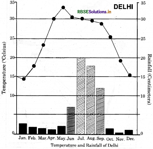
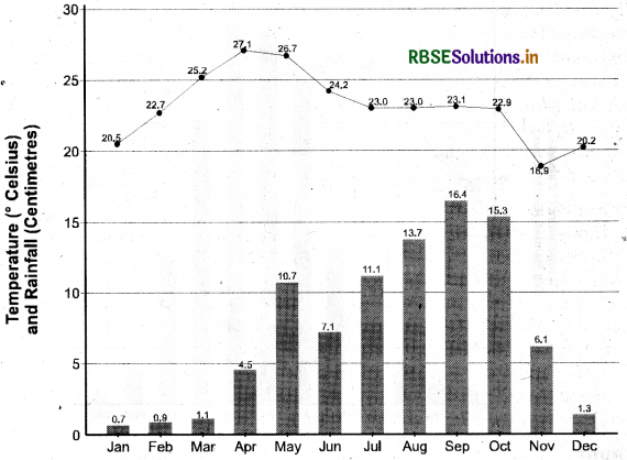
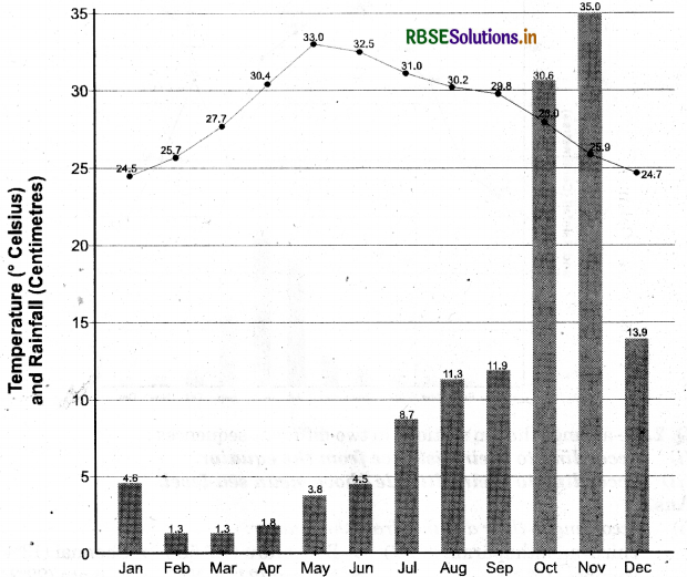
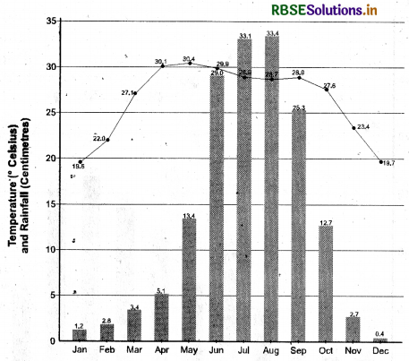
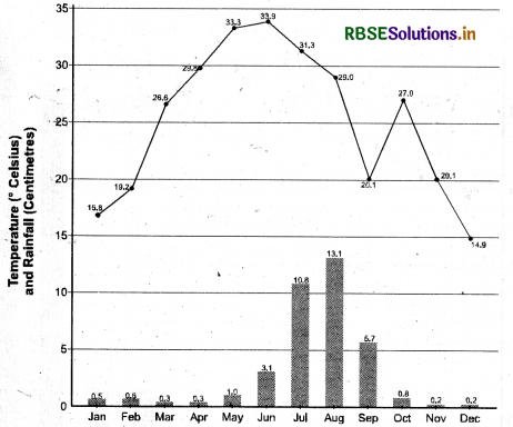
1. In Table-I, the average mean monthly temperatures and amounts of rainfall of 10 representative stations have been given. It is for you to study on your own and convert them into ‘temperature and rainfall’ graphs. A glance at these visual representations will help you to grasp instantly the similarities and differences between them. One such graph (Figure 1) is already prepared for you. See if you can arrive at some broad generalisations about our diverse climatic conditions. We hope you are in for a great joy of learning. Do the following activities.
Delhi
Bengaluru
Chennai
Kolkata
Jodhpur
Question 2.
Re-arrange the ten stations in two different sequences :
(i) According to their distance from the equator.
(ii) According to their altitude above mean sea-level.
Answer:
(i) According to their distance from the equator:
- Thiruvananthapuram (8°29') → Bengaluru (12° 58') → Chennai (13°4'N) →
- Mumbai (19° N) → Nagpur (21° 9' N) → Kolkata (22°34'N) →
- Shillong (24° 349' N) → Jodhpur (26° 18' N) → Delhi (29° 29) →
- Leh (34° N)
(ii) According to the altitude from mean sea- level:
- Kolkata (6 m) → Chennai (7 m) → Mumbai (11m) →
- Thiruvananthapuram (61 m) → Delhi (219 m) → Jodhpur (224m) →
- Nagpur (312 m) → Bengaluru (909 m) → Shillong (1461m) →
- Leh (3506 m)
Question 3.
- Name two rainiest stations.
- Name two driest stations.
- Two stations with most equable climate.
- Two stations with most extreme climate.
- Two stations most influenced by the Arabian branch of southwest monsoons.
- Two stations most influenced by the Bay of Bengal branch of south-west ' monsoons.
- Two stations influenced by both branches of the south-west monsoons
- Two stations influenced by retreating and north-east monsoons.
- Two stations receiving winter showers from the western disturbances.
- The two hottest stations in the months of
- February
- April
- May
- une
Answer:
- Shillong and Mumbai
- Leh and Jodhpur
- Mumbai and Thiruvananthapuram
- Leh and Delhi
- Mumbai and Thiruvananthapuram
- Shillong and Kolkata
- Delhi and Jodhpur
- Chennai and Bengaluru
- Leh and Delhi :
- The two hottest stations in the months of
- February; Thiruvananthapuram and Chennai
- April: Nagpur and Chennai
- May: Nagpur and Jodhpur
- June : Delhi and Jodhpur
Question 4.
Now find out
(i) Why are Thiruvananthapuram and Shillong rainier in June than in July?
Answer:
In the month of June, as the Southwest monsoon advances from the Indian Ocean, there is sudden increase in the rainfall, also called the ‘Burst of monsoon. The Arabian Sea branch reaches Thiruvananthapuram by 1st of June, and the Bay of Bengal branch reaches Shillong at same time resulting in heavy rainfall in both places. However, in July break in monsoons and its advancement towards the north and north west reduces the amount of rainfall.
(ii) Why is July rainier in Mumbai than in Thiruvananthapuram?.
Answer:
The monsoon reaches Thiruvananthapuram by 1st of June, and after heavy
rains in June, there is a break in monsoon by July. On the other hand, the monsoon reaches Mumbai about 10 days after Thiruvananthapuram and the initial impact of the monsoon continues into the next month of July.
(iii) Why are southwest monsoons less rainy in Chennai?
Answer:
South-West monsoon is less rainy in Chennai due to the following reasons:
- The Arabian Sea branch hits the Western Ghats and causes heavy rainfall there. By the time it advances towards Chennai, it becomes off-shore and gives less rain.
- Bay of Bengal branch blows parallel to Tamil Nadu and does not give rainfall.
(iv) Why is Shillong rainier than Kolkata?
Answer:
Shillong is a hilly area and it is surrounded by Assam hills on three side. The monsoons winds hit these hills, get trapped and give heavy rains in Shillong. However, Kolkata lies on the plain and winds can pass easily. Therefore, Shillong is rainier than Kolkata.
(v) Why is Kolkata rainier in July than in June unlike Shillong which is rainier in June than in July?
Answer:
Shillong lies east to Kolkata and therefore falls first in the way of Bay of Bengal branch of South west monsoon. Hence, the monsoon reaches Shillong earlier (in June) than Kolkata, where the monsoons begin in July. So, Shillong is rainier in June while Kolkata is rainier in July.
(vi) Why does Delhi receive more rain than Jodhpur?
Answer:
Delhi receives more rain than Jodhpur because of the following reasons:
Jodhpur lies west of Delhi, and the winds of the Bay of Bengal branch lose much of their moisture by the time they reach Jodhpur.
The height of the Aravalli Range is not high enough to block the rain bearing clouds and cause rain in Jodhpur.
Question 5.
Now think why
(i) Thiruvananthapuram hew equable climate?
Answer:
- Thiruvananthapuram has equable climate because of the following reasons:
- Thiruvananthapuram is located on the sea coast. The moderating influence of the sea makes its climate equable.
- Thiruvananthapuram lies near the equator. Places near equator have roughly similar temperature throughout the year.
(ii) Chennai has more rains only after the fury of monsoon is over in most parts of the country?
Answer:
Chennai receives most of its rainfall from the N orth East monsoon in the months of October to December. During this time, the northeast trade winds prevail over the country.These offshore winds blow from land to sea, and therefore bring little or no rain. However, before entering Tamil Nadu these winds blow over the Bay of Bengal and are laden with moisture. When these enter
the land, the Eastern Ghats act as a barrier which causes winter rainfall in the Tamil Nadu coast.
(iii) Jodhpur has a hot desert type of climate?
Answer:
Jodhpur has a hot desert type of climate because of the following reasons :
- Jodhpur is in the extreme western part of India, and the winds of the Bay of Bengal branch lose much of their moisture by the time they reach Jodhpur.
- The height of the Aravalli Range is not high enough to block the rain bearing clouds and cause rain in Jodhpur.
- Climate
- Further, Jodhpur is on the edge of the Thar Desert.
(iv) Leh has moderate precipitation almost throughout the year?
Answer:
Leh is located in the Great Himalayas. In winter months, Leh receives snowfall because of the Western disturbance and no monsoon winds are able to reach it.
(v) While in Delhi and Jodhpur most of the rain is confined to nearly three months, in Thiruvananthapuram and Shillong it is almost nine months of the year?
Answer:
In Delhi and Jodhpur the monsoons normally arrive on the 1st of July and begin to withdraw by the 15th of September. Hence, the rainy season is hardly of 3 months duration. On the other hand, it rains in Thiruvananthapuram and Shillong almost nine months of the year because:.
- Both places receive pre monsoon rainfall.
- In both places, the monsoon arrives on the 1st of June and withdraw by the 15 of October.
- After this, these places receive rainfall from tropical cyclones.
- Thiruvananthapuram also receives winter rainfall from North east monsoon.

- RBSE Class 9 Social Science Important Questions Civics Chapter 1 लोकतंत्र क्या? लोकतंत्र क्यों?
- RBSE Solutions for Class 9 Social Science Geography Chapter 5 Natural Vegetation and Wildlife
- RBSE Solutions for Class 9 Social Science Geography Chapter 6 Population
- RBSE Solutions for Class 9 Social Science in Hindi Medium & English Medium
- RBSE Class 9 Social Science Important Questions in Hindi & English Medium
- RBSE Class 9 Social Science Notes in Hindi & English Medium Pdf Download
- RBSE Class 7 Social Science Important Questions History Chapter 9 क्षेत्रीय संस्कृतियों का निर्माण
- RBSE Class 9 Social Science Important Questions Civics Chapter 1 What is Democracy? Why Democracy?
- RBSE Class 9 Social Science Notes Civics Chapter 4 संस्थाओं का कामकाज
- RBSE Class 9 Social Science Important Questions Economics Chapter 4 भारत में खाद्य सुरक्षा
- RBSE Solutions for Class 9 Social Science Civics Chapter 5 लोकतांत्रिक अधिकार