RBSE Solutions for Class 11 Geography Chapter 7 Landforms and their Evolution
Rajasthan Board RBSE Solutions for Class 11 Geography Chapter 7 Landforms and their Evolution Textbook Exercise Questions and Answers.
Rajasthan Board RBSE Solutions for Class 11 Geography in Hindi Medium & English Medium are part of RBSE Solutions for Class 11. Students can also read RBSE Class 11 Geography Important Questions for exam preparation. Students can also go through RBSE Class 11 Geography Notes to understand and remember the concepts easily.
RBSE Class 11 Geography Solutions Chapter 7 Landforms and their Evolution
RBSE Class 11 Geography Landforms and their Evolution Textbook Questions and Answers
Multiple Choice Questions
1. Choose the right Answer out of the four alternatives given :
(i) In which of the following stages of landform development, downward cutting is dominated?
(a) Youth stage
(b) Late mature stage
(c) Early mature stage
(d) Old stage.
Answer:
(a) Youth stage

(ii) A deep valley characterised by steep steplike side slopes is known as :
(a) U-shaped valley
(b) Gorge
(c) Blind valley
(d) Canyon.
Answer:
(d) Canyon
(iii) In which one of the following regions the chemical weathering process is more dominant than the mechanical process?
(a) Humid region
(b) Limestone region
(c) Arid region
(d) Glacier region.
Answer:
(a) Humid region
(iv) Which one of the following sentences best defines the term ‘Lapies’?
(a) A small to medium sized shallow depression
(b) A landform whose opening is more or less circular at the top and funnel shaped towords bottom.
(c) A landform formed due to dripping water from surface.
(d) An irregular surface with sharp Pinnacles grooves and ridges.
Answer:
(d) An irregular surface with sharp Pinnacles grooves and ridges.
(v) A deep, long, and wide trough or basin with very steep concave high walls at its head as well as in sides is known as :
(a) Cirque
(b) Lateral moraine
(c) Glacial valley
(d) Esker
Answer:
(a) Cirque.
Short Answer Type Questions
2. Answer the following questions in about 30 words :
Answer:
It is common to find meanders over flood plains and deltas. But very deep or incised meanders can also be found cut in rocks. These show lateral erosion. Meanders develop in the from of loops. Some loop get entrenched due to continued uplift and downcutting. Over time, these form deep gorges and canyons in hard rocks.
(ii) Explain the evolution of valley sinks or uvalas.
Answer:
Valley sinks. Sink-holes are small depressions, formed by solution. These are funnel-shaped. The rain water sinks into these sink-holes. These are known as dolines or swallow holes. Some streams, all of a sudden disappear underground, through swallow holes. Several dolines merge together to form a large depression known as uvala.
(iii) Underground flow of water is more common than surface run off in limestone areas. Why?
Answer:
In Karst regions, there is a general absence of surface drainage. Most of the surface water goes underground. Streams flow only for short distances over limestone areas. Then, these disappear underground. Dry valleys are formed on the surface. Streams develop a system of underground channels, called blind valleys. These streams reappear on the surface after some distance.
(iv) Glacial valleys show up many linear; depositional forms. Give their locations and 1names.
Answer:
Clay and drift are deposited by glaciers after melting. These hillocks are called moraines. The material deposited on the two sides of the glacier is called lateral moraine. Two lateral moraines meet to form medial morianes. Surface moraines are found on the top of glacier. Terminal moraines are found at the end of glacier.
(v) How does wind perform its task in desert regions? Is it the only agent responsible for
the erosional features in desert regions?
Or
Describe the work of wind as an agent of erosion, transfer ortation and deposition.
Answer:
Work of Wind : Wind is an important agent of change in arid regions of the world. Its work is limited to deserts due to absence of vegetation and low rainfall. It creates an arid or aeolian topography.
EROSION. Wind erosion is performed in these ways :
- Under-cutting.
- Gully erosion.
- Scratching.
- Polishing.
Types of Wind Erosion:
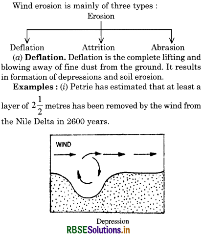
(ii) Blow outs (Depressions). Large depressions, known as blow outs, are formed by deflation. The Qattara depression in Egypt lies almost 143 metres below sea level.
(ii) Abrasion. Abrasion is the work of strong air armed with sand and dust particles which are the tools of wind. It drives them with force against the rocks. Rocks are polished and smoothed. A wind acts like a sand blast.Attrition. Sometimes pieces of wind-blown material collide into each other. It is greatly reduced and grains are formed. This action is called Attrition.
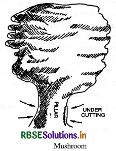
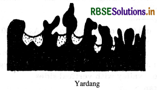
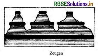
Landforms of Wind Erosion:
1. Mushroom. Under-cutting by wind is maximum at the base of the rocks. It produces thin pillars at the base due to erosion of soft rocks. Hard rocks are left upstanding on these pillars. Hollows are cut in the rock’s surface so that the total picture resembles a mushroom.
2. Yardangs. When hard and soft rocks are arranged vertically, sharp-pointed, steep-sided, overhanging ridges of hard rocks are formed. These are called Yardangs. They are roughly parallel and run in the direction of the prevailing wind. These resemble ribs of a skeleton. These are generally 15 metres high and are found in the deserts of Central Asia.
3. These are formed when soft rocks lie under the layer of hard rocks. Soft rocks are eroded and deep furrows are formed. The flat-topped hard rocks overhang soft rocks. These are called zeugens. These resemble an inkpot with a cap.
4. Bridges and Windows. Sometimes big openings are formed in hard rocks. After a long time, across a hill, windows are formed. These are arch-shaped like Hope window in the U.S.A.
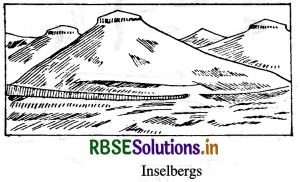
5. Inselberg. Inselbergs are residual hills rising abruptly from the ground. These are composed of hard rocks like granite and gneiss. These have steep slope and rounded tops. They look like dome-shaped pyramids. ‘Inselberg’ is a German word meaning ‘Island mountain’. These are mostly found in Kalahari Desert.
DEPOSITION
When the velocity of wind decreases, it starts depositing its load. Sand dunes and loess deposits are formed due to wind deposition. Sand Dunes. Sand dunes are hills of wind-blown sand. These are found in areas like :
- sandy coasts.
- in deserts.
- on the sandy-shores of lakes.
- along river banks.
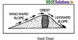
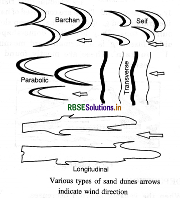
Types of sand dunes :
Sand dunes are of three major types :
(i) Longitudinal dunes. These are long narrow ridges of sand. These lie parallel to the direction of the prevailing wind. They are sometimes 100 metres high. These are called Seif (meaning sword) in Sahara.
(ii) Transfer dunes. These are formed perpendicular to the wind. They look like large waves of sand. They are semi-circular in shape.
(iii) Barchans Barchan is a crescent or moon shaped sand dune formed in a perpendicular direction to the wind. The windward side is convex and gentle while the leeward side is concave and steep. Its ends are called Horns. These resemble a Sickle or Bow. The sand dunes keep on advancing and many towns and buildings have been buried under these sand dunes.
(iv) Loess. Loess is a wind-borne deposit. It is a yellow, porous, fertile deposit. The most extensive deposits are found in the N. W. China in Hwang-Ho- Basin. It covers an area of 3 lakh sq. miles. Actually the word ‘loess’comes from such a deposit in a village of France.
Essay Type Questions
3. Answer the following questions in about 150 words :
(i) Running water is by far the most dominating geomorphic agent in shaping earth’s surface in humid as well as in arid regions. Explain.
Answer:
Work of a River. Wherever water is present, the effect of running water is felt. River is thus the most important single agent of change. A river performs three main types of work :
(A) Erosion
(B) Tranfwer ortation
(C) Deposition.
The erosion, transfer ortation and deposition go on simultaneously. So the work of the river is known as
three-way work.
(A) EROSION:
Rivers are constantly removing material from the land. It is lowering the level of the land. River Mississippi carries over a million tonnes of silt to the Gulf of Mexico daily. Thus, rivers carry the land to the sea.
Types of Erosion :
- Solution. This work is done by the chemical action of the river. It dissolves the soluble rocks, like limestone. The river Thames carries down to the sea in solution 2,50,000 tons of chalk and limestone daily.
- Mechanical Erosion. The load of the river erodes the banks, bottom and bed of the river. This erosion takes place in different ways.
(a) Side cutting. This is the erosion of the banks of the river. It widens the V-shaped valley.
(b) Down cutting. This is vertical erosion. It deepens the river channel.
(c) Attrition. In this, pebbles collide with one another and are broken down into smaller stones.
Factors influencing Erosion:
The erosional work of river depends upon the following factors:
- Volume of water.
- Velocity of water.
- Load of the river.
- The nature of the rocks.
- Slope of the river.
1. V-shaped valley : In mountainous regions, down-cutting produces deep, narrow, V-shaped valleys. In areas of hard rocks, side cutting does not take place. River cuts deep into the valley floor. Narrow deep valleys with high vertical walls are formed. These are called Canyons.
Examples:
Grand Canyon in Colorado (U.S.A.) is 2000 metres deep and 480 Kms. long.
2. Gorges: In areas of hard rocks, the downcutting by a mighty river produces gorges. A gorge is a narrow valley with vertical sides.
Examples:
- The Indus river has cut 5,500 metres-deep gorges across the Himalayas.
- The Brahmaputra river cuts through deep Dihang Gorge.
3. Waterfalls: When river water falls suddenly from some height along a vertical slope, it is known as a waterfall. Waterfalls are formed in mountainous regions, when:
(a) a hard rock lies over a softer rock horizontally. Soft rocks are eroded rapidly.
(b) a hard rock lies vertically across a river.
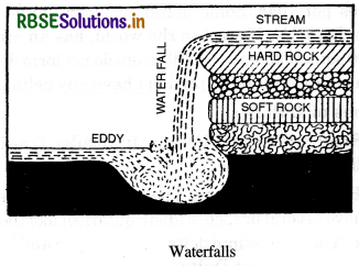
Examples:
- The Niagra Falls in North America, 51 metres high is the most famous falls of the world.
- Jog Falls in India is 260 metres high.
- Victoria Falls in Africa.
4. Rapids: Rapids are a series of small and low waterfalls. Hard rocks outcrop bed of soft rocks. The river jumps or falls down the river. These sections of river along slopes are called rapids. Large falls are known as Cascades or Cataracts.
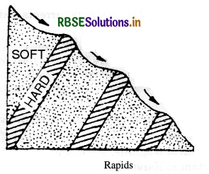
Examples:
Congo River has a series of 32 falls known as Livingstone Falls.
(B) Transfer ROTATION:
River is the most important transfer orting agent. It carries the materials of its own erosion. This is called the load of the river. The load is carried by the river in three ways :
- By traction: the load is rolled along the bed.
- By suspension: sand, silt and mud are suspended in water.
- By solution: minerals are dissolved in water.
The transfer orting power of a river depends upon:
(i) Velocity of a river. The transfer orting power of a river varies as sixth power of its velocity.
Transfer orting power = (Velocity of river) When the velocity is doubled, the transfer orting power is 64 times increased.
(ii) Volume of water. The amount of material transfer orted by large rivers is much greater. During floods, rivers carry much larger load.
(C) DEPOSITION:
As the river flows down towards the sea, the deposition of material starts. Deposition results when:
- the velocity of river decreases
- volume of water decreases
- the load of the river increases
- the river enters a lake or sea
- the river flows over a plain area, with a gentle slope
- the transfer orting power of the river decreases.
Deposition takes place in the lower course of the river. The river deposits its material along its banks, on its bed or in the sea. The following landforms result due to deposition:
1. Alluvial FAnswer: A fan-shaped deposit of material at the base of a mountain is called an alluvial fan. Many alluvial fans were merge to form an alluvial plain like Bhabar Plain at the foot of the Himalayas.
2. Meanders. When a river develops a winding course, the river flows in loops. The river loops are
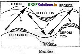
known as Meanders. There is continuous erosion on the steep side of the outer bank. A bottom current deposits the material on the gentle inner bank. In this way, the meanders go on developing till these form a ‘Neck’. The term meander has been taken from the name of a small winding river, Meanders in Turkey. Deep and wide meanders are found in hard rocks. There are called incised and entrenebed meanders.
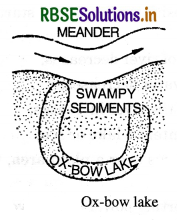
3. Oxbow Lakes. Sometimes the meanders take the shape of letter ‘S’. The river becomes almost a complete circle. The two adjacent meanders approach each other. A swift current cuts through the neck of the meander. The river then flows straight. Its course is shortened. A former bend or loop of the river is separated from the flowing river. This horse-shoe-shaped strip or water is known as ox-bow lake. These lakes resemble the shape of an ox-bow. These are common on flood plains
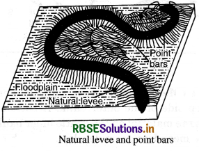
4. Flood Plain. During the floods, there is a widespread deposition of alluvium on both the sides of the river. A layer of fertile soil is deposited during each flood. Gradually, a fertile flood plain is built. Most of the river lowlands are the best agricultural lands of the world, like the plains of the Ganges, the Hwang- Ho, etc.
5. Levees. The river deposits its material on the bed of the river and along its banks. After a long period of such deposition, the river banks are raised. These raised banks of the river are known as levees. Sometimes the flood water breaks through these levees. These banks burst and damage property. That is why the river Hwang-Ho is known as ‘Sorrow of China’.
6. Deltas. When a river enters the sea, it becomes very slow. It deposits all the load at its mouth. Such deposits of silt are known as Deltas. In fact, a delta is seaward extension of the flood plain. A delta is a triangular piece of alluvial land formed at the mouth of the river. It resembles in shape the Greek letter delta, (D) after which it is named. This name was used by the Greeks for the Nile delta. The deltas extend seawards at an amazing rate. Po delta extends 61 metres per year, while the Nile delta extends 4 metres per year. Some deltas are very large. The Ganges delta, the biggest in the world, has an area of 1,25,000 square kilometres. All rivers do not form deltas. The Narmada and the Tapti don’t have any deltas.
Types of Deltas :
(a) Regular Deltas. These are triangular, fan-shaped deltas like Ganges delta.
(b) Bird’s Foot Deltas. These are irregular deltas which have several branches (distributaries) like the foot of a bird. The Mississippi delta is of this type and is also called a Crow’s Nest Delta.
Conditions necessary for the formation of Delta :
- The rivers should have a long mountainous upper course. It increases the load of sediment.
- There should be absence of large lakes in the river course.
- The river should have a long lower course.
- The river should have a number of tributaries to increase its load.
- The sea should be shallow near the delta.
- There should be no strong currents and tides at the mouth of the river.
- Limestones behave differently in humid and arid climates.
Why? What is the dominant; L and almost exclusive geomorphic process in limestone areas and what are its results?
Or
Describe the work of underground water in!
Karst regions.
Answer:
Karst Regions. Work of underground water is important in Karst regions. Karst regions are made of limestone. Limestone is soluble in rainwater. A special type of topography is developed in areas of limestone. Such regions are called Karst Regions. The most important regions of this type of Karst Plateau of Yugoslavia, Florida (U.S.A.) and Khasi Hills (India).
Work of Underground Water. The underground water performs its work in three ways :
(a) Erosion
(b) Transfer ortation
(c) Deposition.
Due to slow movement of water, the work of transfer:rotation is almost negligible.
Erosion. The erosive work of underground water is of two types:
(a) Mechanical
(b) Chemical.
These two types of erosion are done in the following ways :
(b) Solution. When rocks and minerals like limestone and chalk are dissolved in rainwater.
- Hydraulic action. When land slides and avalanches move under the pull of gravity.
- Abrasion. When underground water wears its channel.
Landforms :
(i) Land Slides. It is movement of a large mass of rock along a steep slope. Heavy rain increases the weight or rocks. These rocks slide under the pull of gravity. Landslides are most common in hilly areas. Large pieces of rocks move down the slopes. These are called avalanches. These cause floods and block the roads.
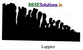
(ii) Lappies. When the joints of limestone become wide by solution, knife-edged ridges are formed. These are called lappies or dints or bogas.
(iii) Sink-holes : Sink-holes are small depressions, formed by solution. These are funnel¬shaped. The rain water sinks into these sink-holes. These are known as dolines or swallow holes. Some streams, all of a sudden disappear underground, through swallow holes. Several dolines merge together to form a larger depression known as Uvala. Dry valleys are formed on the surface of the earth when a river goes underground. The river forms a blind valley when it flows underground.

(iv) Caves. Rain water dissolves limestone rocks. The joints are enlarged and underground caves are formed. Underground galleries are formed in such caves. The Mammoth cave (U.S.A.) is 50 kilometres long. The caves of Kotamsar (Madhya Pradesh) are 100 metres long and 12 metres high. When the roof of a cave collapses, huge depressions are formed known as Poljes. The remnants of a cave form natural bridges of hard rocks such as marble arch.
Deposition. Deposition takes place under the following conditions:
(i) Due to loss of carbon dioxide in water.
(ii) When the solvent power of water decreases.
(iii) Due to rapid evaporation.
(iv) When the pressure and temperature decrease.
Landforms. Underground water dissolves many rocks and minerals. Many landforms result due to the deposition of these solutions.
(i) Stalactites. The water containing limestone seeps through the roof of a cave. A chain of drops hangs from the roof. After evaporation a small deposit of limestone is left on the roof. In this way, sharp, slender, downward-hanging pillars are formed. These are called Stalactites. Sometimes, these pillars take the shape of organ pipes and hanging curtains.
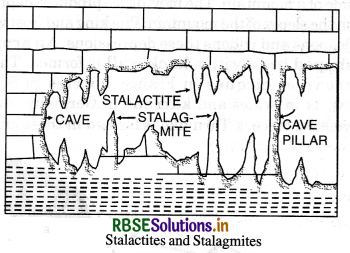
(ii) Stalagmites. Some drops of limestone fall on the floor. After evaporation, some limestone is deposited on the floor of the cave. It begins to rise upward. A short, wide, rounded pillar is formed. This conical-shaped pillar is called a stalagmite.
(iii) Cave pillars. After a long time, the stalactites and stalagmites join together. They form a complete cave pillar, from the floor to the roof of the cave.
(iii) Describe the work of glacier as an agent of Erosion, Transfer ortation and Deposition.
Answer:
Work of Glacier. Glacier like other agents, plays a combined role of erosion, transfer ortation and deposition throughout its course. On mountain slopes and valleys, its work is mainly erosion; on plateaus its work is mostly protective; on lowlands, its work is deposition. Erosion. A glacier performs its erosion by different actions like:
- Plucking
- Grooving
- Abrasion.
- Grinding
(a) Polishing.
A glacier plucks big pieces of rocks from the underlying rocks. Big hollows are formed on the valley floor. The glacier collects big pieces of rocks from avalanches and landslides. These fragments are the powerful tools of glacier. The glacier scratches, polishes the rock surfaces and grinds the pebbles and stones at its bottom. In this way, mountains are rounded and valleys are deepened and widened. The general rugged highland area becomes smooth.
The glacier erosion depends upon the following factors:
- Amount of Ice.
- Nature of the rocks.
- Movement of glaciers.
- Slope of the land.
Landforms, formed by Erosion :
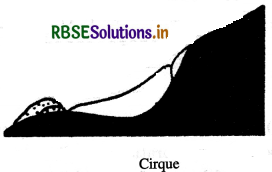
1. Cirque. Cirques are semi-circular hollows at the side of a mountain. The moving ice produces depressions on the slopes of the mountain. Plucking and frost wedging deepens and widens these depressions. An armchair-shaped basin with a back wall is formed. These are known as cirques in France, corries in Scotland, cwms in Wales and karrens in Germany. After the melting of ice, a Tarn like is formed in these cirques.
2. Horns. Sometimes several cirques are formed on all sides of a mountain. These cirques cut back together until these almost meet. A horn-shaped pyramid is formed. This sharp pointed peak is known as Horn. The Matter Horn of Switzerland is a classic example.
3. Col. Col is a saddle shaped pass through mountains. When on the opposite sides of a ridge, two cirques meet, a col is formed.
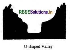
4. U-shaped Valley. When a glacier enters a V-shaped valley, it changes its shape. The glacier widens and deepens the valley. A V-shaped valley thus becomes a U-shaped valley. A U-shaped valley has a wide flat floor and steep sides. St. Lawrence valley of North America is a U-shaped valley. Drowned glaciated valleys are known as fiords; as along the coast of Norway.
5. Hanging Valley. A hanging valley is formed by a tributary glacier. The main glacier forms a much deeper valley than a tributary glacier. After the ice has melted, the tributary valley is left at a higher level than the main valley. Such valleys appear hanging above the main valley and are called hanging valleys.

Transfer ortation. Glacier carries different types of material (load). This material comes from avalanches, great heights, valley floor and walls.
The glacier transfer orts boulders, clay, till, drift, gravel, sand, etc. These materials are transfer orted in different ways:
- dragged under the bottom of the glacier.
- carried on the surface of the glacier.
- collected in the layers of the ice.
Deposition. When a glacier melts, it is called the retreat of a glacier. Most of the material brought by glacier is deposited. These deposits are called Till or Drift. Glacier deposits its material in the form of hillocks. These are known as moraines. According to the place of deposition, moraines are of the following four types:
(i) Lateral Moraines. The material deposited on the two sides of the glacier is called a Lateral or Marginal Moraine. It is a ridge of loose and broken material, rising to a height of 100 feet
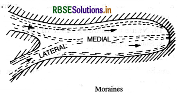
(ii) Medial Moraines. These are formed by the meeting of two glaciers. When two glaciers meet at a point, the inner lateral moraines unite to form only one ridge. This ridge along the middle of the main glacier is called a medial moraine.
(iii) Terminal Moraines. When the glacier melts, some material is left behind at the Snout of the
glacier. This is called End moraine or Terminal moraine.
(iv) Ground Moraines. The material deposited underneath a glacier is called a ground moraine. These are found scattered on valley floor.
(v) Other Landforms. After the melting of the glacier, many streams flow from the end of the glacier. These streams deposit sand and gravel in different layers to form an outwash plain; kettle lakes are formed by filling of depressions with water. Oval shaped deposits like an inverted boat are formed and known as Drumlins. These deposits appear like eggs in a basket. Long narrow ridges called eskars and small rounded hillocks called kames are formed at the end of the glacier

- RBSE Solutions for Class 12 Geography Chapter 11 अंतर्राष्ट्रीय व्यापार
- RBSE Solutions for Class 11 Geography Chapter 1 भारत - स्थिति
- RBSE Solutions for Class 11 Geography Chapter 3 पृथ्वी की आंतरिक संरचना
- RBSE Solutions for Class 8 Our Rajasthan Chapter 5 उद्योग
- RBSE Solutions for Class 11 Geography Chapter 2 संरचना तथा भूआकृति विज्ञान
- RBSE Solutions for Class 11 Geography Chapter 1 भूगोल एक विषय के रूप में
- RBSE Class 11 Geography Important Questions Chapter 7 Natural Hazards and Disasters
- RBSE Class 11 Geography Important Questions in Hindi & English Medium
- RBSE Class 11 Geography Important Questions Chapter 6 Soils
- RBSE Class 11 Geography Important Questions Chapter 5 Natural Vegetation
- RBSE Class 11 Geography Important Questions Chapter 4 Climate