RBSE Class 11 Geography Important Questions Chapter 3 Interior of the Earth
Rajasthan Board RBSE Class 11 Geography Important Questions Chapter 3 Interior of the Earth Important Questions and Answers.
Rajasthan Board RBSE Solutions for Class 11 Geography in Hindi Medium & English Medium are part of RBSE Solutions for Class 11. Students can also read RBSE Class 11 Geography Important Questions for exam preparation. Students can also go through RBSE Class 11 Geography Notes to understand and remember the concepts easily.
RBSE Class 11 Geography Important Questions Chapter 3 Interior of the Earth
Multiple Choice Questions
1. Which of the following is the main source of the structure of the earth?
(A) Seismic waves
(B) Volcanoes
(C) Earth’s density
(D) Earth’s temperature.
Answers:
(A) Seismic waves

2. What is the density of the ground surface?
(A) 17.2
(B) 5.68
(C) 2.75
(D) 5.53.
Answers:
(C) 2.75
3. What name is given to core of the earth?
(A) Sial
(B) Sima
(C) Nife
(D) Mentle.
Answers:
(C) Nife
4. What is the cause of the high density in the core?
(A) Depth
(B) High temperature
(C) Liquids
(D) Nickel and Iron.
Answers:
(D) Nickel and Iron.
5. What is the average rate of increase in temperature?
(A) 1°C per km
(B) 12°C per km
(C) 1°C per 30 metres
(D) 10°C per 100 metres
Answers:
(C) 1°C per 30 metres
6. The average density of material of crust is
(A) 5.53
(B) 3.5
(C) 2.75
(D) 11.
Answers:
(C) 2.75
7. Which waves disappear after a depth of 2900 km?
(A) Primary
(B) Secondary
(C) Surface
(D) Transverse.
Answers:
(B) Secondary
8. Which instrument records earthquake waves?
(A) Thermograph
(B) Seismograph
(C) Hygrograph
(D) Barograph.
Answers:
(B) Seismograph
9. In which type of volcano eruptions are frequent?
(A) Dead
(B) Dormant
(C) Extinct
(D) Active.
Answers:
(B) Dormant
10. The words core and crator are related to
(A) Earthquake
(B) Glaciers
(C) Volcanoes
(D) Tectonic movements.
Answers:
(C) Volcanoes
Very Short Answer Type Questions
Question 1.
Up to which depth, man’s knowledge of structure of earth, is limited?
Answer:
Up to a depth of 12 km.
Question 2.
Name the three layers of the earth.
Answer:
Crust, mantle and core.
Question 3.
What does the word SIAL stand for?
Answer:
The crust consisting of silica and aluminium (SIAL).
Question 4.
What does the word SIMA stand for?
Answer:
Question 14.
Which volcano is known as the ‘light¬house of
Answer:
SIMA is the layer below sial (Silica + Aluminium = SIMA).
Question 5.
What does the word NIFE stand for?
Answer:
The centre core of the earth (Nickle + Ferrous = NIFE).

Question 6.
What is the density of NIFE?
Answer:
17 and 2500 km.
Question 7.
From which Greek word, the term! volcano has been derived?!
Answer:
From Greek word ‘Vulcan’ meaning God of the Underground.
Question 8.
What name is given to the molten matter within the earth?
Answer:
Magma.
Question 9.
What name is given to magma, when it appears on the surface of the earth?
Answer:
Lava.
Question 10. Name the main parts of a volcano.
Answer:
- Vent or opening
- Volcanic pipe
- Crater.
Question 11.
Name two types of volcanic eruptions.
Answer:
- Central eruption
- Fissure eruption.
Question 12.
Name an active volcano in India.
Answer:
Barren island near Andaman islands.
Question 13.
Name the largest active volcano in the world.
Answer:
Mauna Loa (Hawaii islands). the Mediterranean?’
Answer:
Stromboli.
Question 15.
Which type of volcanoes are called ‘sleeping volcanoes?’
Answer:
Dormant volcanoes.
Question 16.
Name the three belts where volcanoes are found.
Answer:
- Circum Pacific belt
- Mid-world mountain belt
- African rift valley.
Question 17.
What is a crater?
Answer:
A funnel-shaped hollow at the centre of a Volcano.
Question 18.
What is a caldera?
Answer:
A large depression or crater.
Question 19.
What is an earthquake?
Answer:
A sudden shaking of earth.
Question 20.
Name three causes of earthquakes.
Answer:
- Volcanic eruptions
- Tectonic causes
- Elasticity of Rocks.
Question 21.
What is epicentre?
Answer:
The point on earth’s surface vertically above the focus is called epicentre.
Question 22.
On what scale, is earthquake recorded?
Answer:
On Richter scale devised by an American Charles Francis Richter.

Question 23.
Name the tidal waves caused by earthquakes.
Answer:
Tsunamis.
Question 24.
What is radius of the earth?
Answer:
6,370 km.
Short Answer Type Questions
Question 1.
What do you understand by the term ‘Discontinuity’?
Answer:
The boundary separating the different layers of the earth is called Discontinuity. This demarcates the different layers of the earth having different densities.
Question 2.
Define the terms Sial and Sima.
Answer:
Sial: It is the uppermost layer of the earth. It consists of Silica and Aluminium. (Sial = Silica + Aluminium). Its average depth is 60 kms. It has an average density of 2.75. Sima : The layer below the Sial is called Sima. It consists of Silica and Magnesium (Sima = Silica + Magnesium). Its average depth is 2800 kms. It has a density of 4.75.
Question 3.
Define the term Nife.
Answer:
Nife : The core of the earth is called ‘Nife’. It consists of Nickel and Ferrous. It has an average depth of 3500 kms. It has a density of 13.
Question 4.
Name the direct and indirect sources of information regarding the interior of the earth.
Answer:
Direct Sources :
(i) Mines
(ii) Wells
(iii) Bores Indirect sources :
(i) Temp
(ii) Pressure
(iii) Density
(iv) Earthquake waves
(v) Meteroites
(vi) Gravity.
Question 5.
How are earthquakes measured?
Answer: Measuring earthquakes. The earthquake events are scaled either according to the magnitude or intensity of the shock. The magnitude scale is known as Richter scale. The magnitude relates to the energy released during the quake while the intensity scale takes into account the visible damage caused by the event. The magnitude is expressed in absolute number 0 to 10. The intensity scale is named after Mercalli, an Italian seismologist. The range of intensity scale is from 1 to 12. The intensity relates to the actual damage caused by the quake. On the Richter scale, earthquakes with high intensity are rare.
Question 6.
Write a short note on ‘Barysphere’.
Answer:
Barysphere. The central core of the earth is called Barysphere. It has a depth of 4980 km to 6400 kms. It has a density of 17. It consists of heavy minerals and is called core also. The core is metallic in nature.
Question 7.
Describe the location and importance of ‘Shadow Zone’.
Answer:
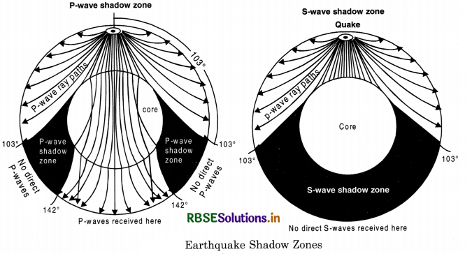
Due to reflection and refraction suffered by earthquake waves, some areas do not experience any waves. Such areas are called ‘Shadow Zones’. From the epicentre, S-waves are deflected at an angle of 103° to 143° only. P-waves travel down to the boundary at the Core. These waves suffer reflection and refraction and emerge on the surface as P.K.P. waves. Thus two shadow zones on either side of the core are formed. These suggest the presence of the liquid core. These zones are free from earthquake waves. Only surface waves pass through it.
Question 8.
What do you mean by Mohorovicic Discontinuity?
Answer:
The abrupt changes in the velocity of seismic waves suggest that the crust is distinguished from the mantle. The surface of sudden increase in wave velocity which separates the crust above from the mantle below is called Mohorovicic discontinuity or M discontinuity. The P waves near the surface travel at about 6 km per second and increase to 7 km per second to the base of the crust. This is named after the Yugoslav seismologist Mohorovicic who first recognised
the discontnuity in 1909.
Question 9.
How is it that our knowledge is based on ; indirect observations about the structure of • earth’s interior?
Answer:
High temperatures are found in the interior on the earth. So direct observation is not possible as man cannot go deep down. Direct observation is limited only to a depth of 3 kms. Deepest mines go up to a depth of 3 kilometres. Due to increase in temperature with depth, we reach a very high temperature (2000° C) in the interior. Mines, wells and boreholes provide a limited knowledge. The depth of the deepest borehole (6 kilometres) is quite insignificant as compared to the radius of the earth (6,400 kms). So, we have to depend upon indirect sources of evidences like earthquake, waves, volcanic eruptions and meteorites.

Question 10.
How do we know that the core of earth is liquid?
Answer:
Three types of earthquake waves have different types of path and velocity. Both P and S-waves are reflected and refracted while passing through a different layer. S-waves cannot travel through liquid and have never been observed in the core. Hence, the core is considered liquid. The rigidity of the material of the core is zero, which is also a characteristic of a liquid core.
Question 11.
What is a Seismogram?
Answer:
Seismograph is an instrument which records earthquake waves. Study of Seismographic record is called Seismogram.
Question 12.
Name two types of surface waves.
Answer:
Surface waves are those earthquake waves which move freely along the upper crust of the earth. These produce disastrous effects of earthquakes. These are of two types:
(a) Rayleigh Waves or R-waves. These are named after the English Physicist, Lord Rayleigh. These are similar to water waves travelling across the surface of a still pond when a pebble is tossed into water. Figure 2 shows Rayleigh waves.
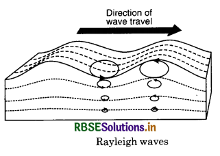
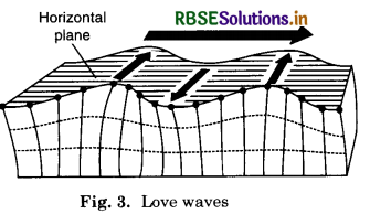
(6) Love waves or L-waves. The second type of surface waves is the love wave. These are named after the Physicist A.E.H. Love. These move in a horizontal plane. These move at right angle to the direction of wave motion. Figure 3 shows Love Waves.
Question 13.
What is an asthenosphere?
Answer:
Asthenosphere is a part of upper mantle layer of earth. It has a depth of about 650 kms. from crust to lower mantle. The asthenosphere occupies 300 to 400 kms. of upper mantle. This layer has elastic— viscous substances. So, it behaves as an elastic and plastic layer at the same time. The presence of soft layer or plastic layer was observed by Seismologist Beno Gutenburg. This is a low-velocity zone as the earthquake wave velocity slow down below 150 kms.
Question 14.
What do you mean by ‘Ring of Fire’?
Answer:
Most of the active volcanoes are found along the coast of Pacific Ocean. These volcanoes erupt and throw out gases, lava etc. This circum-pacific belt of volcanoes is called the ‘Ring of Fire’.
Question 15.
Define a Volcano.
Answer:
A Volcano is a vent or opening in the earth’s crust through which eruption of hot materials takes place. During the eruption, rock fragments, lava, ash, steam and gases are emitted. A funnel shaped hollow through which eruption takes place is called a crater.
Question 16.
What are the three types of Volcanoes?
Answer:
On the basis of the mode and frequency of eruption, volcanoes are classified into three types :
(i) Active volcanoes. The volcanoes that erupt frequently and are always emitting lava are called active volcanoes. Mauna Loa in Hawaii islands is the largest active volcano in the world. There are about 1500 active volcanoes in the world.
(ii) Dormant volcanoes. Dormant Volcanoes are also called sleeping volcanoes. These volcanoes have been active in the past; stopped ejecting lava now, but can erupt any time. The Vesuvius of Italy is such a dormant volcano.
(iii) Extinct volcanoes. The volcanoes which have never erupted in human history are called extinct or dead volcanoes, such as Kilimanjaro in Africa.
Question 17.
Describe the different types of volcanic eruptions.
Answer:
A volcanic eruption. When solid, liquid and gaseous materials are thrown out of the interior of the earth, it is known as a volcanic eruption. There are two main modes of eruption.
(i) Central eruption. When lava erupts through a vent, violent explosion takes place. It results in the formation of volcanic cone; such as the Vesuvius and Fujiyama.
(ii) Fissure eruption. When there is a quiet upwelling of lava through fissures over a large area, it is known as fissure eruption. It gives rise to extensive lava plains or plateaus. Deccan trap of Peninsular India is an example of this type.

Question 18.
Answer:
Write short notes on :
- Rift Valley
- Focus
- Epicentre
- Fissure
- Ring of Fire
- Tsunamis.
Answer:
- Rift Valley. The land between two parallel faults subsiding into a depression is known as a Rift Valley.
- Focus. The place of origin of an earthquake inside the earth is called its Focus.
- Epicentre. The point on the earth’s surface vertically above the focus is called the epicentre.
- Fissure. When lava rises through cracks, it is called fissure eruption.
- Ring of fire. The Circum Pacific belt of volcanoes is called “ring of fire”.
- Tsunamis. Seismic waves caused in oceans are called Tsunamis in Japan.
Question 19.
Why is the Circum Pacific Volcanic; -J region known as the Ring of Fire?
Answer:
Most of the active volcanoes of the world are found in the Circum Pacific Belt. It surrounds the Pacific Ocean. These active volcanoes erupt often. These volcanoes form a circle around the Pacific Coast. Therefore, it is known as the ring of fire.
Question 20.
What are Tsunamis? Give an example of destruction caused by it.
Answer:
Sometimes, seawaves rise very high due to earthquakes. These tidal waves are called Tsunamis in Japan. These waves cause a great damage to life and property in coastal area. In 1883, an earthquake was recorded due to Karakatoa volcanic explosion. The waves rose by 15 metres killing 36,000 persons on the spot.
Question 21.
Describe the different parts of a volcano.
Answer:
- Volcanic Vent. Extrusion of Lava takes place from an opening called volcanic vent.
- Crater. A saucer shaped depression is created around the vent and is known as crater.
- Caldera. Due to explosion, a steep sided crater is formed and called caldera.
Comparison Questions
Question 1.
Distinguish between longitudinal and transverse waves.
Answer:
|
longitudinal |
transverse |
|
1. In these waves, particles move to and fra in the direction of the waves. |
1. In these waves, particles move at right angles to the direction of the waves. |
|
2. These are known as Primary waves or P-waves or sound waves. |
2. These are known as Secondary waves or S-waves. |
|
3. These waves can travel through liquid, solid and gaseous media. |
3. These waves travel only in solid medium. |
Question 2.
Distinguish between the crust and the core of the earth.
Answer:
|
Crust of the earth |
Core of the earth |
|
1. This is the outermost layer of the earth. |
1. This is the innermost layer of the earth. |
|
2. It has an average density of 2.73. |
2. It has an average density of 17.2. |
|
3. It covers about 0.5% part of the earth. |
3. It covers about 83% part of the earth. |
|
4. It is made up of silica and aluminium. |
4. It is made up of Nickel and Ferrous. |
Question 3.
Distinguish between body waves and surface waves. Answer:
|
Body Waves |
Surface Waves |
|
1. P and S waves are called body waves. |
1. L waves and R waves are called surface waves. |
|
2. These travel through the solid body of the earth. |
2. These move along the free upper crust of the earth. |
|
3. These do not pass through liquid medium. |
3. These can pass through liquid medium and move at right angles to surface. |
Question 4.
Distinguish between Gutenburg discontinuity and Mohorovicic discontinuity.
Answer:
|
Gutenburg discontinuity |
Mohorovicic discontinuity |
|
1. The boundary between the mantle and core is called Gutenburg dis continuity. |
1. The boundary between crust and the mantle is called Mohorovicic discontinuity. |
|
2. It was observed by Seismologist Beno Gutenburg in 1926. |
2. It was observed by Yugoslav seismologist Mohorovicic in 1909. |

Essay Type Questions
Question 1.
What are earthquake waves? Describe’ their types and characteristics.
Answer:
Earthquake waves provide the most reliable information regarding the structure of the earth. The vibrations recorded during an earthquake are called waves. The place within the earth where the vibrations begin is known as the focus. The place vertically above the focus on the surface of the earth is known as Epicentre. Epicentre is vertically above the focus at an angle of 90°. These waves are recorded by an instrument known as Seismograph. There are three types of earthquake waves:
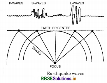
waves. These waves travel at a speed of 5 to 12 km. per second. These waves reach the surface of the Earth at the earliest.
2. Transverse Waves. These are known as Secondary waves or S-waves. In these waves, particles move right angles to the direction of waves. These waves are slow and travel only in solid medium.
3. Surface Waves. These waves travel on the surface of the Earth and produce disastrous effects of earthquakes. These are called Long waves or L-waves. These are also known as Rayliegh waves or R-waves. Their intensity decreases with depth. These waves move along the boundaries between solid, liquid and gaseous mediums.
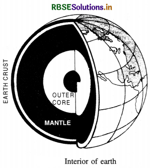
These waves are the last to reach the earth surface. These are the most destructive waves. The structure of the earth is a mystery for man. Different views have been expressed about the structure of the earth. Our knowledge is not based on direct observations. Only earthquake waves are the indirect source of information. The paths and velocity of these waves suggest the following features about the layers of the earth:
- The earth can be divided into three layers-Crust, Mantle and Core.
- The Crust is composed of different types of rocks.
- The crust consists of light rocks with an average density of 2.7 only.
- The Core consists of the heaviest materials with an average density of 17.2.
- Below the crust, there is uniformity of material up to a depth of 2900 kms.
- The core has a thickness of 2,600 kms.
- Earthquake waves change their path and speed due to presence of discontinuities between different layers.
- The absence of the S-waves in the core suggests a liquid core of the earth.
Question 2.
Describe the structure of Earth, giving details about each of its layers or shells and; arguments in support of your answer.
Or
Discuss how do Seismic waves suggest layering of earth interior.
Answer:
Structure of the Earth. Different views have been suggested regarding the interior of the earth. The interior of the earth is beyond the reach of direct observations. The high temperatures are a great hindrance. Direct observations are limited only to depths of 4 kms. The deepest mine in the world, in South Africa, is about 4 km deep. The depth of the deepest bore hole is 6 km. So we have to depend upon indirect sources of evidences.
DIFFERENT LAYERS OF THE EARTH
Vander Gracht has suggested the following layers of the earth:
1. Outer Sial. This is the uppermost layer of the earth. It is composed of light rocks with a density of 2.75 to 2.90. Its average depth is 45 kilometres. This layer is also called crust. Continents have been formed by this layer. Silica and aluminium predominate in this layer and hence it is also called (Si + al) Sial.
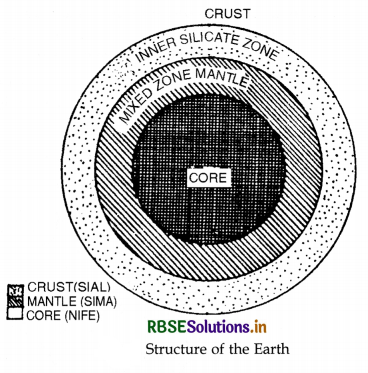
2. Inner Silicate Zone. This layer is found below top layer of Sial. The boundary between the outer and inner layer is called Conrad discontinuity. It has an average thickness of 1,140 kms. and a density of 3.10 to 4.74.
3. Mixed Zone. Next to Sial, a heavier layer is known as Mantle. It is of two common elements of silica and magnesium; hence it is called (Si + ma) Sima. It has a depth of 1,700 km. and an average density of
4.75 to 5.00. The layer separating Sial and Sima is called Mohorovicic Discontinuity.
4. Nucleous. The central core of the earth is called Nucleous or Barysphere. It consists of the heaviest materials like Nickel and Ferrous and hence called (Ni + fe) Nife. It has a thickness of 3500 km. with an average density of 4.75 to 11. The core (Barysphere) has density of 13 to 17.

Layers of the Earth
|
Main layer |
Name of the layer |
Density |
Thickness |
Physical property |
|
1. Crust |
(a) Sial (b) Outer silicate layer |
2.7 2.75-2.90 |
8-45 km 45-100 km |
Silica + Aluminium Partly molten |
|
2. Mantle |
(а) Sima (in part) (b) Sima (whole) |
3.10-4.75 4.75-5.00 |
100-1,700 km 1,700-2,900 km |
Silica + Magnesium Ultra basic rock |
|
3. Core |
(a) Nife (b) Barysphere |
5.10-13.00 13.00-17.00 |
2,900-4,980 km 4,980-6,400 km |
Nickel + Ferrous Heavy metals |
Question 3.
escribe the distribution pattern of volcanoes in the world.
Answer:
Distribution of volcanoes. There are about 500 active or dormant volcanoes. Most of the volcanoes of
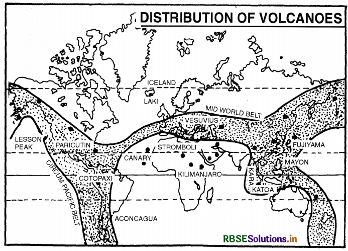
the world are found in coastal areas or unstable regions or areas affected by earthquakes. These volcanoes are distributed in three well defined belts.
(i) The Circum Pacific Belt. This belt surrounds the Pacific Ocean. It is also known as ‘Pacific ring of fire’. Some of the well-known volcanoes are Karakatoa (Java), Mayon (Philippines), Fujiyama (Japan), Cotopaxi (Bolivia).
(ii) The Mid-World Mountain Belt. This belt extends in an east-west direction along the Alpine- Himalayan Region. It includes some well-known volcanoes of the world such as Vesuvius, Strombli, Etna (Mediterranean Sea). This belt runs along the Himalayas, Myanmar to Indonesia.
(iii) The African Rift Valley. This belt passing through the Red Sea extends upto Rift Valley of East Africa. The most important volcanoes are Kilimanjaro (Tanzania) and Mt. Kenya.
(iv) Other Volcanoes. Scattered volcanoes are found in the island groups of different oceans as Canary islands, Cape Verde islands, St. Helena, Icelands, Azores islands (Atlantic Ocean) Hawaii island (Pacific Ocean) Barren island (Indian Ocean) (erupted in May 1991).
Question 4.
Describe the volcanic activity and the major features associated with it.
Answer:
Vulcanicity. Vulcanicity is an endogenous process through which the heated materials (solid, liquid or gaseous) move from the interior towards the surface of the earth. It results in evolution of a distinct volcanic topography. It includes high relief features like mountains, cones, domes etc. which are known as positive relief features. The low lying features like Caldera, Crater, etc. are called negative relief features. The materials thrown out during eruptions are deposited around the crater in the form of volcanic cones.

Land-forms of Volcanic Topography:
1. Crater. A crater is a funnel-shaped hollow formed at the centre of volcano. It is formed by an explosion. A crater filled with water is known as a crater lake, such as Lonar lake in Maharashtra.
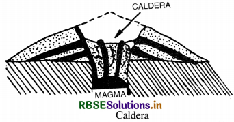
2. Caldera. Calderas are very large volcanic depressions. Calderas are formed by explosion and collapse. The top of the cone is blown off and a broad depression or crater is formed. Caldera of Japan is called “A volcano of hundred villages”.
3. Ash Cones. Ash or cinder cones are made of loose ash and dust. They have concave slopes.
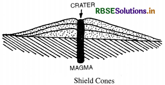
4. Shield Cones. These are formed by basic lava which is poor in silica. It cools down quickly and travels a long distance. These are flat, low cones with a small angle of slopes such as Mauna Loa in Hawaii Islands.
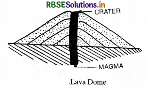
5. Lava Domes. These are formed by acid lava which is rich in silica. It cools down slowly around the crater. These are steep, convex-sided high domes such as Puy de dome in France.
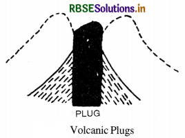
6. Volcanic Plugs. These are domes of thick viscous lava. After the dome is dissected, a volcanic neck or plug remains as a column, such as Lassen Peak in the U.S.A
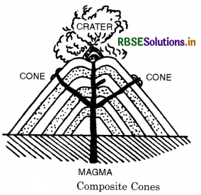
7. Composite Cones. These cones are built by alternative layers of ash, lava and other fragments. It is built over a long period of time. Most of the largest, highest and symmetrical volcanic mountains of the world are of this type. One of the best examples is Strombli, known as ‘The Lighthouse of the Mediterranean’.
8. Flood basalt provinces is a another strange type of‘volcano’. Some parts of the world are covered by thousands of square kilometers of thick basalt lava flows- some flows are more than 50 meters thick, and individual flows extend for hundreds of kilometers. The Deccan Traps from India are a much large flood basalt province.
9. Mid-ocean ridge volcanism occurs at plate margins where oceanic plates are created. There is a system of mid-ocean ridges more than 70,000 km long that stretches through all the ocean basins-some folks consider this as the largest volcano on Earth. Here, the plates are pulled apart by convection in the upper mantle, and basalt lava intrudes to the surface to fill in the space. Or, the basalt intrudes to the surface and pushes the plates apart.
Question 5.
Define an earthquake and state the causes of earthquakes.
Answer:
An Earthquake. An earthquake is a sudden movement on the crust of the earth. It is a sudden shaking of the crust which results in tremors or vibrations. These vibrations of the crust are called earthquakes. The earthquake proceeds in the form of waves in all directions from its origin or focus. Causes of Earthquakes. In ancient times, man thought of earthquakes as an expression of God’s anger. But causes based on
scientific ideas are as under :
1. Volcanic eruptions. Volcanic eruptions exert a pressure and earthquake occurs in adjoining areas. In 1883, Karakatoa eruption was the main cause of earthquakes experienced.
2. Tectonic causes. Earthquakes are mostly caused by tectonic forces. These forces produce faults in crust. The San Francisco earthquake of 1906, Bihar earthquake of 1934 are examples of this type of earthquakes. Energy is released at the edges of faultts.
3. Elasticity of rocks. Under pressure rocks are displaced. These rocks try to regain their position and cause earthquakes.
4. Local causes. Sometimes, earthquakes limited to small areas occur due to local causes such as landslides in mountainous areas, collapse of roofs of caves in Karst regions, huge waves in sea like Tsunamis and atomic explosions.

Question 6.
Write down the effects of an earthquake.
Answer:
There are various environmental effects caused by an earthquake like surface faulting, tsunamis, soil liquefactions, ground resonance, landslide, and ground water failure. Some of the immediate hazardous effects are ground shaking. Mud and landslides, ground lunching, avalanches, fires, ground displacement, structural collapse etc. all of the effects cause damage of buildings and hurt people. Earthquakes effect our lives in different ways. They cause fires that burn building etc. earthquakes generally caused when rock underground breaks along a fault. This sudden release of energy results the seismic waves which make the ground shake. So when the rocks break, the earthquake caused. It causes great damage.
Question 7.
Why do the earthquake waves develop shadow zones?
Answer:
Propagation of earthquake waves and emergence of shadow zone. While it is true that the earthquake waves get recorded world over, scientists were surprised to find that earthquakes are not recorded in some specific zone. Such a zone is called ‘shadow zone’. The study of different events revealed that for each earthquake there existed altogether different shadow zone. Figure 3.3 a-c shows the shadow zones of ‘P’ and ‘S’ waves. It was observed that seismographs located at any distance within 105°from the epicentre recorded the arrival of both P and S waves.
Seismographs located beyond this the region lacked the records both the waves. However, the seismographs located beyond 145° from epicentre record arrival of ‘P’ waves, but not ‘S’ waves. Thus a zone between 105° to 145° from epicentre was identified as the shadow zone for both the types of waves. The zone beyond 105° does not receive S waves. The shadow zone of S waves is much larger than that of the P waves. This observation helped scientists to locate the mantle-core boundary. You can draw shadow zone for any earthquake provided you know the location of epicentre.
Source-Based Questions:
1. Read the following paragraph and answer the questions given below:
Different views have been suggested regarding the interior of the earth. The interior of the earth is beyond the reach of direct observations. Van der Gracht has suggested layers of the earth. These are the uppermost layer of the earth composed of light rocks with a density of 2.75 to 2.90 and average depth of 45 kilometres is called crust. Since the silica and aluminium predominate in the layer it is also called sial. Inner silicate zone is below the top layer of the sial. Mixed zone is next to sial and called mantle. It is composed of two common elements of silica and magnesium, hence it is called Sima. It has a depth of 1700 km and an average density of 4.75 to 500. Nucleus is the central core of the earth. It is also called Barysphere.
(i) Which of the following is a layer of the earth?
(a) Mantle
(b) Core
(c) Crust
(d) All of these
Answer:
(d) All of these
(ii) All of these
(a) Outer sial
(b) Inner Silicate zone
(c) Mixed zone
(d) All of these
Answer:
(d) All of these
(iii) In which layer is sial present?
(a) Crust
(b) Core
(c) Mantle
(d) Cover mantle
Answer:
(a) Crust
(iv) What is the density of the mixed zone?
(a) 4.75 to 5.00
(b) 5.00 to 5.01
(c) 4.70 to 5.00
(d) 4.75 to 5.02
Answer:
(a) 4.75 to 5.00
(ii) Which of the following is a layer suggested by Van der Gracht?
2. Read the following paragraph and answer the questions given below:
There are two types of body waves and these waves are P waves and S waves. P waves are those that move faster and are the first to arrive at the surface. These waves are also famous as primary waves. Sound waves and P waves are the same. These travel through gas, liquid and solid. At the surface, with some time lag, S waves arrive. These waves are called secondary waves.
An important fact about S waves is that they can travel only through solid materials. Characteristic of S waves is quite important. It helped scientists to understand the interior structure of the earth. Reflection causes waves to rebound whereas refraction makes waves move in several directions. The differences in the direction of waves are inferred with the help of their record on seismograph.
(i) Which waves are called primary waves?
(a) P waves
(b) S waves
(c) Shear waves
(d) All of these
Answer:
(a) P waves

(ii) Which waves are called secondary waves?
(a) P waves
(b) S waves
(c) Pressure waves
(d) All of these
Answer:
(b) S waves
(iii) Which instrument is used to report the surface waves?
(a) Hygrograph
(b) Thermometer
(c) Seismograph
(d) Barometer
Answer:
(c) Seismograph
HOTS QUESTIONS I ((Solved))
Question 1
Describe the distribution of earthquakes prone regions of the world. Is there any relationship between a volcano and an earthquake?
Answer:
Earthquakes occur in almost every part of the world but they are frequent in two well defined belts.
1. Circum Pacific Belt. This belt is located along the edges of the Pacific Ocean. This belt experiences 68% earthquakes of the world. It includes North and South America, island groups of Eastern Asia and Philippines.
2. Mid-world mountain belt. It extends along the fold mountains of Europe and Asia. It runs
through the Alps, the Caucasus and the Himalayas. About 21% earthquakes of the world originate in this belt.
3. Other areas. About 11% earthquakes of the world originate in other areas such as Mid Atlantic, Rift valley of East Africa and Central Siberia. There is a close relationship between an earthquake and a volcano. Earthquakes and volcanoes occur in same belts i.e. mid world belt and circum pacific belt. Their distribution shows a similar pattern. Volcanic eruptions lead to earthquakes. Volcanic eruptions are the local causes of earthquakes.
SELF EVALUATION TEST
- What does the word sial stand for? 1
- Name the main parts of a volcano. 1
- Name all active volcanos in India. 1
- What is a crater? 1
- Name the three fundamental layers of the earth.
- What is a seismograph? 2
- What is a ‘Shadow Zones’? 2
- Name three types of volcanos. 3
- Distinguish between Longitudinal and Transverse waves. 3
- Describe the distribution pattern of volcanoes in the world. 4

- RBSE Solutions for Class 12 Geography Chapter 11 अंतर्राष्ट्रीय व्यापार
- RBSE Solutions for Class 11 Geography Chapter 1 भारत - स्थिति
- RBSE Solutions for Class 11 Geography Chapter 3 पृथ्वी की आंतरिक संरचना
- RBSE Solutions for Class 8 Our Rajasthan Chapter 5 उद्योग
- RBSE Solutions for Class 11 Geography Chapter 2 संरचना तथा भूआकृति विज्ञान
- RBSE Solutions for Class 11 Geography Chapter 1 भूगोल एक विषय के रूप में
- RBSE Class 11 Geography Important Questions Chapter 7 Natural Hazards and Disasters
- RBSE Class 11 Geography Important Questions in Hindi & English Medium
- RBSE Class 11 Geography Important Questions Chapter 6 Soils
- RBSE Class 11 Geography Important Questions Chapter 5 Natural Vegetation
- RBSE Class 11 Geography Important Questions Chapter 4 Climate