RBSE Class 11 Geography Important Questions Chapter 2 Structure and Physiography
Rajasthan Board RBSE Class 11 Geography Important Questions Chapter 2 Structure and Physiography Important Questions and Answers.
Rajasthan Board RBSE Solutions for Class 11 Geography in Hindi Medium & English Medium are part of RBSE Solutions for Class 11. Students can also read RBSE Class 11 Geography Important Questions for exam preparation. Students can also go through RBSE Class 11 Geography Notes to understand and remember the concepts easily.
RBSE Class 11 Geography Important Questions Chapter 2 Structure and Physiography
Multiple Choice Questions
1. What is Rift Valley?
(A) Ganga
(B) Narmada
(C) Chambal
(D) Damodar
Answer:
(B) Narmada

2. Which is the oldest landmass of India?
(A) Northern plains
(B) Peninsular plateau
(C) Himalayas
(D) Aravallis
Answer:
(B) Peninsular plateau
3. The highest peak of Himalayas in India is
(A) Mt. Everest
(B) Kanchenjunga
(C) K2
(D) Dhaulgiri
Answer:
(B) Kanchenjunga
4. The southern part of west coastal plain is called.
(A) Konkan coast
(B) Coromandel coast
(C) Kanara coast
(D) Malabar coast
Answer:
(A) Konkan coast
5. Where is pitti bird sanctuary located?
(A) Andaman islands
(B) Nicobar Islands
(C) Lakshadweep
(D) Maldives
Answer:
(C) Lakshadweep
6. Which sea existed in place of Himalayas in ancient period.
(A) Tethys
(B) Southern
(C) Arabian
(D) Indian
Answer:
(A) Tethys
7. The plateau between Aravallis and Vindhyas.
(A) Bundelkhand
(B) Malwa
(C) Baghelkhand
(D) Chhotanagpur
Answer:
(B) Malwa
8. How many geological plates are there in the earth?
(A) 5
(B) 6
(C) 7
(D) 8
Answer:
(C) 7
9. Which is the ancient landmark of India?
(A) Northern plain
(B) Peninsular plateau
(C) Himalayas
(D) Aravalli
Answer:
(B) Peninsular plateau
10. Name the highest peak of southern India?
(A) Doddabetta
(B) Anamudi
(C) Mahendragiri
(D) Kalsubai
Answer:
(B) Anamudi
Very Short Answer Type Questions
Question 1.
Into how many Physiographic units can India be divided at Macro Level?
Answer:
Three.
Question 2.
Which is the ancient crustal Block in India?
Answer:
Deccan Plateau.
Question 3.
Name the Eastern Boundary of Deccan plateau.
Answer:
Rajmahal Hills.
Question 4.
When was peninsular plateau of India formed?
Answer:
In the Pre-Cambrian Period.
Question 5.
In which period were the Aravalli uplifted?
Answer:
Vindhyan Period.
Question 6.
How were different layers of Lava formed in Deccan plateau?
Answer:
By Lava flows (volcanic eruptions).
Question 7.
Name two Rift valleys found in India.
Answer:
Narmada and Tapti Valleys.
Question 8.
Name the sea which existed in place of the Himalayas.
Answer:
Tethys sea.
Question 9.
In which period were the Himalayas uplifted?
Answer:
In tertiary period.
Question 10.
Which landmass was situated in north of the Himalayas?
Answer:
Angara land.
Question 11.
Name the landmass situated in the South of Himalayas in tertiary period.
Answer:
Gondwana land.
Question 12.
Name the lake deposits found in Kashmir Valley.
Answer:
Karewas.
Question 13.
Name the Western boundary of the Deccan plateau.
Answer:
Aravallis.
Question 14.
What is the extent of the Himalayas between Indus Gorge and Brahmaputra Gorge?
Answer:
2400 Kms.
Question 15.
What is the height of the Highest peak, Mount Everest, in the Himalayas?
Answer:
8848 metres.
Question 16.
What is the East-West extent of the Northern plains of India?
Answer:
3200 Kms.
Question 17.
What is the maximum depth of alluvium in the Ganga plain?
Answer:
2000 metres.
Question 18.
Name the deposits found along the foot hills of the Himalayas.
Answer:
Alluvial Cones.
Question 19.
Name the area known for Chos.
Answer:
Hoshiarpur (Punjab).
Question 20.
What is the average elevation of Peninsular plateau of India?
Answer:
600-900 metres.
Question 21.
Name an area where Barchans are found.
Answer:
Jaisalmer.
Question 22.
Name a plateau found in North-East of Peninsular India.
Answer:
Shillong Plateau.
Question 23.
Name the direction of the Slope of Deccan plateau.
Answer:
South-East.
Question 24.
Name the areas where Granite and Gneiss rocks are found in India.
Answer:
Karnataka.
Question 25.
What is the maximum height found on the Western Ghats?
Answer:
1600 metres.
Question 26.
What is the maximum height found on the Eastern Ghats?
Answer:
900 metres.
Question 27.
Name a group of coral islands found in Arabian Sea.
Answer:
Lakshadweep Islands.
Question 28.
Name the highest mountain peak of the Peninsular India.
Answer:
Anamudi (2695 metres).
Question 29.
Name the two sections of the western coastal plain.
Answer:
Konkan Coast and Malabar Coast.
Question 30.
If a person is to travel to Lakshadweep, from which coastal plain does he prefer and why?
Answer:
West coastal plain-Due to nearness.
Short Answer Type Questions
Question 1.
Into how many physiographic units can (Si) India be divided at the macro level? Name
them.
Answer:
At the macro level, India can be divided into three broadly defined physiographic units. These are :
- The Himalayas and associated mountain chains.
- The Indus, Ganga, Brahmaputra plains.
- The peninsular plateau.
Question 2.
What do you understand by “Bangar”?
Answer:
The plain formed by the older alluvium is known as the Bangar. These areas stand above the level of flood water and the flood plain. This raised land is made up of clay, pebbles and gravel. In Gangetic plains, these alluvial lands have been formed by the deposition of sediments by the river.
Question 3.
What is a dun? Give three examples from the Himalayan region.
Answer:
A dun is a narrow longitudinal valley in between two parallel mountain ranges. These are formed by the deposition of sediments. The important duns-formed in the Himalayas are :
- Dehradun.
- Kothridun.
- Patlidun.
Question 4.
What do you understand by the term terai?
Answer:
Terai is a long narrow zone south of Bhabar plains along the foothills of the Himalayas. It is a damp area (with wetlands and marshes) with thick forest growth. Many streams form the Bhabar remerge in this region. The terai plain is 20-30 kms. wide. It is covered with thick forests. These areas have been reclaimed for cultivation.
Question 5.
What is Bhabar? Give two important characteristics of a Bhabar belt.
Answer:
The Bhabar is a long narrow plain along the foothills of the Shivalik. They extend from the Indus to the Tista rivers with remarkable continuity. Many streams descend from the hills, deposit pebbles, gravel and sand here. It has a width of 8 to 16 kms. The rocks are porous. Characteristics. (i) Many streams go underground in this belt due to porous rocks.
(ii) It is a pebble-studded zone of porous beds.
Question 6.
What do you understand by the term “Doab” ? Give five examples from the Indian sub¬continent.
Answer:
Doab is a floodplain formed in between two rivers. Doabs separate two rivers but maintain a uniform character over the whole areas. Five Doabs in Punjab maintain a physical unity of the Punjab plains :
- Best Jalandhar Doab. Between the Sutlej and the Beas.
- Bari Doab. Between the Beas and the Ravi.
- Rachna Doab. Between the Ravi and the Chenab.
- Chaz Doab. Between the Chenab and the Jhelum.
- Sind Sagar Doab. Between Jehlum-Chenab and the Indus Rivers.
Question 7.
Divide the Himalayas into different mountain ranges.
Answer:
There are many parallel mountain ranges in the Himalayas. These ranges are separated from each other by dun valleys. There are three parallel mountain ranges.
- The great Himalayas or Inner Himalayas.
- The lesser Himalayas or Middle Himalayas.
- Sub-Himalayas (Shiwaliks) or Outer Himalayas.
Question 8.
Name some of highest peaks found in the Himalayas.
Answer:
There are about 40 peaks with a height more than 7000 metres.
- Mount Everest-8,848 metres.
- Kanchenjunga-8586 metres.
- Makalu-8485 metres.
- Dhaulagiri-8167 metres.
- Nanga Parbat-8126 metres.
- Annapurna-8091 metres.
- Nanda Devi-7816 metres.
- Namcha Barwa-7782 metres.
- K2 Mt. Godwin Austin-8611 metres.
Question 9.
Name four largest glaciers of India.
Answer:
- Siachen - 75 Km.
- Hispar - 62 Km
- Baltro - 58 Km.
- Biofo - 59 Km.
Comparison Questions
Question 1.
Compare and contrast the geomorphological features of the Himalayas with. those of the Indian plateau.
Answer:
|
The Himalayas |
Indian Plateau |
|
1. The Himalayas are young new fold mountains. |
1. The Indian plateau is an ancient crystalline tableland. |
|
2. These mountains have been formed due to folding by different earth movements. |
2. This plateau has been formed as a horst. |
|
3. The relief features show young age of the Himalayas. |
3. The plateau is old and well dissected. |
|
4. Parallel mountain ranges are formed in the Himalayan region. |
4. Rift valleys are formed due to faulting. |
|
5. These mountains are the loftiest mountain system of the world with the highest mountain peak Mt. Everest 8848 mts. above sea level. |
5. It is an old eroded crystal Block with the highest peak Anamudi 2695 mts. above sea level. |
|
6. These mountains extend in an arc. |
6. This plateau is triangular in shape. |
|
7. Deep gorges and unshaped valleys are formed. |
7. Narrow deep river valleys are formed on the plateau. |
|
8. These have been formed out of Tethys sea in Mesozoic period. (276 million years ago.) |
8. This pleateau has been lifted out of the sea in the precambrian period (1600 million years ago). |
|
9. It is made up of sedimentary rocks. |
9. It is made up of igneous rocks. |
Question 2.
Distinguish between the eastern and the western coastal plains (State three geographical differences).
Answer:
|
Western Coastal Plains |
Eastern Coastal Plains |
|
1. Terai is a broad long zone south of Bhabar plain. |
1. Bhabar is a long narrow plain along the foothills. |
|
2. It is a marshy damp area covered with thick forests. |
2. It is a pebble-studded zone of porous beds. |
|
3. It is 20-30 kms. wide. |
3. It is 8-16 kms. wide. |
|
4. Many streams re-emerge here from the Bhabar area. |
4. Streams are lost in the region due to porous rocks. |
|
5. It is suitable for Agriculture. |
5. It is unsuitable for Agriculture. |
Question 3.
Distinguish between Terai and Bhabar region.
Answer:
|
Terai |
Bhabar |
|
1. The older alluvium of the plain is called Bangar. |
1.The younger alluvium of the plain is called Khadar. |
|
2. This area stands above the level of the flood plain. |
2. Flood water spreads a new layer over it every year. |
|
3. It is composed of calcareous Kankars and clay. |
3. It is composed of fertile alluvium. |
|
4. The flood water does not reach here. |
4. These are actually flood plains of the rivers. |
|
5. In some areas, local name Dhaia is given to this. |
5. In some areas local new name Bet is given to this. |
Question 4.
Distinguish between Bangar and Khadar.
Answer:
|
Bangar |
Khadar |
|
1. West Coast is a narrow alluvial plain with a width of 50-80 kms. |
1. The Eastern Coast has a wide plain with well developed delta 80 to loo km. wide. |
|
2. Beautiful lagoons are found on the Malabar Coast. |
2. The Eastern Coast has only two or three lagoons. |
|
3. The short swift rivers do not make any deltas on the Western Coast. |
3. The large rivers make wide deltas on the Eastern Coast. |
Essay Type Questions
Question 1.
“The present-day geomorphological divisions of the subcontinent have evolved in the course of a long geological history.” Elaborate the above statement.
Answer:
Indian subcontinent is divided into three physiographic regions at macro level. These have been evolved in the course of a long geological history. The past is still a mystery. The present-day topography is the result of interaction of different courses over a long period
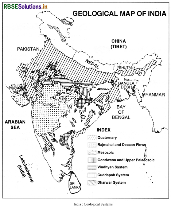
1. The Plateau :
The peninsular plateau is an old crystal block lifted in the pre years ago). It has been compared to a horst lifted above sea level. It has been a part of the super continent Gondwana land. Many structural changes occurred in the evolution of the plateau such as:
- Aravallis mountains were uplifted in Palaeo-zoic times.
- Nallamalai range of the south was folded during the same period i.e. Vindhyan period.
- Faulting along with vertical movements occurred in the river valleys of Godavari, Mahanadi, Narmada and Tapti.
- Along with faulting, subsidence took place along the Malabar Coast.
- After that, extensive lava flow resulted in the formation of Deccan plateau.
- Arabian Sea was formed due to subsidence along the west coast.
- Similarly western ghats were formed as a result of the tilting of the peninsular plateau.
2. The Himalayas :
The Himalayas are young fold mountain system. This region was occupied by the tethys geogyncline as late as mesozoic times (270 million years back). The sediments deposited in the tethys sea were folded to form the Himalayas during the tertiary period. The Himalayas and its mountain ranges were gradually uplifted spreading over millions of years. The Himalayas were uplifted in three stagesCentral Himalayas, Potwar region and the Siwalik ranges. The mountain building movements occurred in different stages.
The first uplift was marked during oligocene period. The second phase took place during the Miocene period. The third phase took place in the post-Pliocene period. It has been observed that the Himalayas are still rising. Most of the present relief is the result of weathering and erosion by different agents. The Himalaya phases of mountain building may be explained in the light of the theory of Plate tectonics. The Himalaya ranges were formed when the Indian plate was driven northwards and pushed beneath the Eurasian plate.
3. The plains :
The great plains of India lie in between the Himalayas and the plateau. It has been formed by filling of a marine depression by sediments brought down by the Himalayan rivers. The depression is derived to exist as a ‘foredeep’ formed by the subsidence of the northern flank of the plateau. The depression has been filled gradually. Rajmahal and Garo hills have been regarded as the boundaries of this depression and this gap has been filled by the Ganges alluvium in Bengal.
Question 2.
Divide India into major physiographic divisions. Describe each in detail.
Answer:
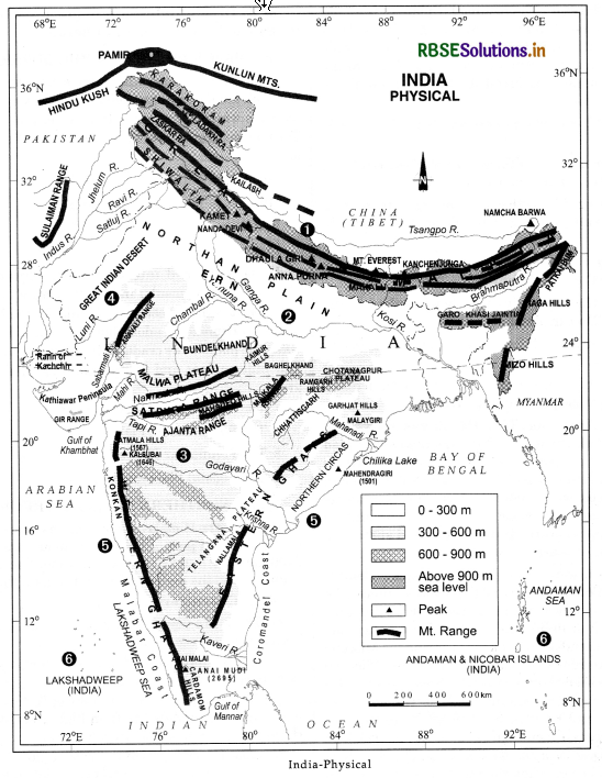
MAJOR PHYSIOGRAPHIC DIVISIONS
India is a vast country where severe contrasts are found in relief. It has a unique relief marked by a variety of features which stand out boldly in contrast to others. The total geographical area is divided into different parts as :
Mountains 10.7%
Hills 18.6%
Plateaus 27.7%
Plains 43.0%
India is divided into four major physiographic divisions. The Peninsular India is the core of the geology of India. It is the oldest part of India. In the Northern part, the Himalayas adorn like a crown of India. The Gangetic plain is the cradle of Indian Civilisation. The four independent and definite physiographic regions are :
- The Northern Mountain Region
- The Sutlej-Ganga Plain
- The Peninsular Plateau
- The Coastal Plain and Islands.
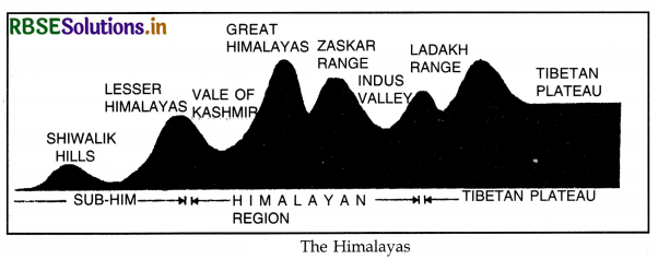
1. THE NORTHERN MOUNTAIN REGION
Extent: The Himalayas run in an east-west direction in the northern part of India. This mountain range is 2400 km. long and 240 to 320 km. wide. These are the youngest and the highest fold mountains of the world. Main Characteristics
- These are young fold mountains as these have been formed in recent times.
- These have been formed in tertiary period (5 crore years ago).
- These were formed at the site of Tethys Sea. The sediments were uplifted to form high mountains. The Himalayas are still rising in some parts.
- The Himalayas are a series of parallel ranges intersected by deep valleys and broad plateaus.
- These ranges are compared to a sword or a bow.
- The average height of the Himalayas is 5000 metres.
- Youthful rivers form narrow, deep valleys and gorges across the Himalayas.
- The Himalayas show evidences of glaciation such as Karewas in Kashmir valley.
Regional Division. The Himalayas, from Indus valley to Arunachal Pradesh, can be divided into four divisions:
Assam Himalayas-Between the Tista and Brahmaputra rivers. (720 km. long)
- Nepal Himalayas-Between Kali and Tista rivers. (800 km. long)
- Kumaon Himalayas-Between Sutlej and Kali rivers. (320 km. long)
- Kashmir Himalayas-Between Indus and Sutlej rivers. (520 km. long)
From the point of height, 136 the Himalayas can be divided into four ranges which run parallel to each other.
- Trans Himalayas
- Great Himalayas or (inner Himalayas)
- Lesser Himalayas or (middle Himalayas)
- Sub-Himalayas (Shiwaliks) or (outer Himalayas).
1. Trans Himalayas. Trans Himalayas include Karakoram, Ladakh and Kailash ranges which overlook the great Himalayas. K2, Mt. Godwin Austin (8611 metres) is the world’s second-highest peak. It is a region of lofty peaks and glaciers. Siachen glacier is one of the longest glaciers of the world.
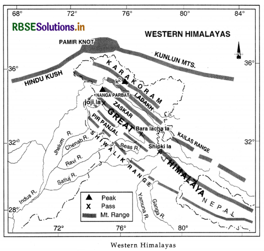
2. Great Himalayas. It is the largest mountain range between Indus and Brahmaputra rivers. It has an average height of 6000 metres. These are snow covered mountains and are called ‘Himadari’ mountains. Two valleys have been formed by filling up of lakes-as Kashmir valley and Kathmandu valley.
|
Peaks |
Height |
|
(i) Mt. Everest |
8848 metres |
|
(ii) Kanchenjunga |
8586 metres |
|
(iii) Makalu |
8485 metres |
|
(iv) Nanga Parbat |
8126 metres |
|
(v) Dhaulagiri |
8167 metres |
|
(vi) Annapurna |
8091 metres |
|
(vii) Nanda Devi |
7816 metres |
|
(viii) Namcha Barwa |
7782 metres |
3. Lesser Himalayas. These ranges have an average height between 3000 to 4500 metres. This range
lies parallel to great Himalayas in the southern part. It is often called ‘Himachal’ or Middle Himalayas. Pir Panjal, Dhauladhar, Kumaon, Thimpu ranges are found in different parts of it. Many tourist resorts are situated on lesser Himalayas.
4. Shiwaliks. These are also called outer Himalayas. These are the foothills of the Himalayas. Its average height is 1000 metres. Its width varies between 15 to 50 kms. In between the Shiwaliks and lesser Himalayas. Doons (longitudinal valleys) are found such as Dehradun, Kothridoon and Patlidoon. Eastern Offshoots. Patkoi, Lushai, Naga hills, Garo-Khasi, Jaintia hills form the eastern offshoots of the Himalayas. Western Offshoots. Salt range, Kirthar, Sulaiman ranges are the western offshoots of Himalayas

- RBSE Solutions for Class 12 Geography Chapter 11 अंतर्राष्ट्रीय व्यापार
- RBSE Solutions for Class 11 Geography Chapter 1 भारत - स्थिति
- RBSE Solutions for Class 11 Geography Chapter 3 पृथ्वी की आंतरिक संरचना
- RBSE Solutions for Class 8 Our Rajasthan Chapter 5 उद्योग
- RBSE Solutions for Class 11 Geography Chapter 2 संरचना तथा भूआकृति विज्ञान
- RBSE Solutions for Class 11 Geography Chapter 1 भूगोल एक विषय के रूप में
- RBSE Class 11 Geography Important Questions Chapter 7 Natural Hazards and Disasters
- RBSE Class 11 Geography Important Questions in Hindi & English Medium
- RBSE Class 11 Geography Important Questions Chapter 6 Soils
- RBSE Class 11 Geography Important Questions Chapter 5 Natural Vegetation
- RBSE Class 11 Geography Important Questions Chapter 4 Climate