RBSE Class 11 Geography Important Questions Chapter 13 Water (Oceans)
Rajasthan Board RBSE Class 11 Geography Important Questions Chapter 13 Water (Oceans) Important Questions and Answers.
Rajasthan Board RBSE Solutions for Class 11 Geography in Hindi Medium & English Medium are part of RBSE Solutions for Class 11. Students can also read RBSE Class 11 Geography Important Questions for exam preparation. Students can also go through RBSE Class 11 Geography Notes to understand and remember the concepts easily.
RBSE Class 11 Geography Important Questions Chapter 113 Water (Oceans)
Multiple Choice Questions
1. The extent of continental shelf in all the oceans is.
(A) 6.0 %
(B) 6.5 %
(C) 7.0 %
(D) 7.5 %.
Answer:
(D) 7.5 %.

2. Which is the largest ocean of the world?
(A) Pacific Ocean
(B) Atlantic Ocean
(C) Indian Ocean
(D) Arctic Ocean.
Answer:
(A) Pacific Ocean
3. What is the average depth of continental shelf?
(A) 30 metres
(B) 32 metres
(C) 20 metres
(D) 22 metres.
Answer:
(A) 30 metres
4. The area covered by Hydrosphere
(A) 361 million sQuestion km.
(B) 366 million sQuestion km.
(C) 320 million sQuestion km.
(D) 700 million sQuestion km.
Answer:
(A) 361 million sQuestion km.
5. The deepest part of ocean is.
(A) Mariana Trench
(B) Sundra Deep
(C) Japan Trench
(D) Kurite Trench.
Answer:
(A) Mariana Trench
6. Which lake has the highest salinity?
(A) Dead Sea
(B) Lake Van
(C) Sambhar lake
(D) Caspian.
Answer:
(B) Lake Van
7. Which is the longest ridge in Ocean?
(A) Indian Ocean Ridge
(B) Mid Atlantic
(C) Dolphin
(D) Greenland.
Answer:
(B) Mid Atlantic
8. What is the average salinity of Oceans?
(A) 10%
(B) 20%
(C) 25 %
(D) 35 %.
Answer:
(D) 35 %.
9. What is the depth of Mariana Trench?
(A) 11022 metres
(B) 11000 metres
(C) 12000 metres
(D) 12022 metres.
Answer:
(A) 11022 metres
10. The continental shelf covers about of the total area of OceAnswer:
(A) 7.5 %
(B) 5.5 %
(C) 7.9 %
(D) 7.6 %.
Answer:
(A) 7.5 %
Very Short Answer Type Questions
Question 1.
Name the major oceans of the world.
Answer:
(1) The Pacific
(2) The Atlantic
(3) The Indian
(4) The Arctic
(5) Southern Ocean.
Question 2.
Name the most common features of the Oceanic land.
Answer:
- Continental shelf
- Submarine canyons
- Continental slope
- Deep sea plains.
- Submarine ridges.
- Ocean deeps.
Question 3.
Name some important Submarine canyons.
Answer:
- Oceanographer Canyon.
- Indus Canyon.
- Berring Canyon.
Question 4.
What is Hydrosphere?
Answer:
The part of earth submerged under water.
Question 5.
Why is earth called a ‘watery planet’ or ‘blue planet’?
Answer:
Due to excess of water.
Question 6.
Which hemisphere is called water hemisphere?
Answer:
Southern Hemisphere.
Question 7.
Which instrument records the depth of oceans?
Answer:
Sonic depth record (Echo sound recording method).
Question 8.
What are economic advantages of shelves?
Answer:
These are rich fishing grounds. These are sources of oil and gas; sand and gravel.
Question 9.
What is abyssal plain? What is its area?
Answer:
Deep sea plain. About 77% area of the oceans were:
Question 10.
Name an important submarine ridge.
Answer:
Mid-Atlantic ridge.
Question 11.
What is an ocean trench?
Answer:
A long, narrow, steep sided depression.
Question 12.
Name two important trenches.
Answer:
Mariana trench, Kurile trench.
Question 13.
How many ocean deeps are there in the oceans?
Answer:
57 deeps.
Question 14.
Which is the largest ocean?
Answer:
Pacific ocean.
Question 15.
What is continental Margin?
Answer:
It is the margin of each continent occupied by shallow seas and gulfs.
Short Answer Type Questions
Question 1.
What do you understand by Hydrosphere
Answer:
Hydrosphere. The part of the earth submerged by oceans and seas is known as Hydrosphere. The vast oceans cover an area of about 361 million sq kms. which is 71% of the total area of the earth surface. Many scientists called the earth as a ‘Watery Planet’. Nearly 61% of the northern hemisphere and 81% of the southern hemisphere is covered by water. The southern hemisphere is known as ‘Water hemisphere’ due to excess of water. The distribution of land and water is Antipodal on the earth. The Arctic ocean surrounds the north pole and the Antarctica continent encircles the south pole.
Question 2.
What do you mean by Antipodal position?
Answer:
The distribution of land and water on the globe is antipodal. Each continent is located diametrically opposite to an ocean. If there is land in one part of the globe, there is water opposite to it on the other side of the earth. For example Arctic Ocean is opposite to Antarctica continent. Europe and Africa are antipodal to Pacific Ocean, while North America is antipodal to Indian Ocean.
Question 3.
Explain the characteristics and formation of submarine canyons.
Answer:
Submarine Canyons. Narrow deep ‘V’ shaped valleys cut deep into the continental shelf and slope are called submarine canyons. These occur close to the river mouths around all the coasts of the world such as river Hudson, Mississippi, Indus, Ganges and Congo. There are about 102 submarine canyons in this world.
Types of Canyons :
There are three types of canyons:
- Small gorges found on the shelf and slope such as the oceanographer canyon in new England region.
- Canyons which begin at the mouth of the river and extend over the shelf such as the canyons of Mississippi river.
- Deep dissected canyons such as along the coast of California.
Origin. The submarine canyons have been formed by different aerial processes and submarine processes.
- By a rise or fall of sea level in the Pleistocene period.
- Canyons are river-cut valleys which have been submerged due to downfaulting.
- Marine erosion has formed the canyons at great depth.
- Erosion by Turbidity currents along the edge of the shelf has resulted in the formation of canyons.
Question 4.
What do you mean by continental shelf?;
Answer:
Continental shelf is a shallow zone around a continent with an average depth of 150 to 200 metres. It
is a shallow platform submerged under water. In fact, continental shelf is an extension of continents.
Question 5.
Which is the deepest place in the oceans in the world?
Answer:
The deepest place in the world lies near Guam islands in Mariana Trench. Its depth is 11022 metres. If the Mt. Everest were to be submerged in this trench, its peak will still remain 2 km below the sea level.
Question 6.
List the various direct and indirect uses of ocean to man.
Answer:
Direct uses :
- Oceans are infinite storehouse of fish.
- Oceans are storehouse of minerals.
- Oceans provide the cheapest means of transportation.
Indirect uses :
- Oceans control the climate.
- Oceans can be used to produce Tidal power and Geothermal energy.
Question 7.
Why did Indian Ocean consider half-ocean?
Answer:
Atlantic Ocean and Pacific Ocean open out both northward and southward. Both are balanced along the equator. But Indian Ocean is blocked on the North by Asia. In fact it extends only southward. Therefore it is considered half ocean.
Comparison Questions
Question 1.
Distinguish between Continental Shelf and Continental Slope.
Answer:
|
Continental Shelf |
Continental Slope |
|
1. The shallow sub-merged platform around a continent is called continental shelf. |
1. The steep slope descend-ing from the shelf to the deep ocean floor is called continental slope. |
|
2. Its average depth is 200 metres (100 fathoms). |
2. Its average depth is from 200 metres to 300 metres. |
|
3. It has an average slope of 1° |
3. Itsaverageslopeisfroml0 to 5°. |
|
4. It has a great economic significance due to fisheries and off-shore petroleum fields. |
4. Many important canyons are found on the continental slope. |
Question 2.
Distinguish between submarine canyons and trenches.
Answer:
|
Submarine canyons |
Trenches |
|
1. These are found in the deepest parts of the oceans. |
1. These are found on the con-tinental shelf and slope. |
|
2. These are long, narrow, deep depressions. |
2. These are narrow, steep sided 'V' shaped river val-leys. |
|
3. These are found along the fold mountains. |
3. These are found at the river mouths. |
|
4. Mariana trench, which is 11 km deep is the deepest trench. |
4. Bering canyon, 400 km. long is the largest canyon in the world. |
Essay Type Questions
Question 1.
Describe the general features of submarine relief of a typical ocean floor.
Answer: Submarine relief. The ocean basins have relief features similar to the land surface. The irregularities on the ocean beds are shown diagrammatically with the help of hypsographic curve. According to this curve, the ocean floor can be divided into the following parts:
1. Continental Shelf. It is a shallow zone around a continent from the shore-line to the continental edge, with an average depth of 100 fathoms. Continental shelf is thus a shallow platform sub-merged under water. Extent. The continental shelf covers about 7.5% of the total area of the oceans (about 26 million sQuestion kms.). It has the maximum extent(13.3%) in the Atlantic Ocean. It has an average width of 80 kms. It is absent along coast of Chile and an average depth of 30 metres.
Some shelves are 600 metres deep. It extends to over 1500 kms. around the coast of Arctic Ocean (The largest shelf). Narrow shelves are found along the coasts having high mountains. The mean slope of the shelf is less than one degree. Origin of Continental Shelf. There are three different views about the origin of continental shelf.
(A) Many writers believe that the shelf is an extension of the continents. It has been formed due to a rise in level of sea or a fall in the level of land.
(B) Shelf has been formed by the erosion of sea waves and ocean currents.
(C) The third view is that the continental shelf (Terrace) has been formed by the deposition of sediments by rivers and winds.
Importance. The continental shelf is of great economic significance to man. These areas have rich
fishing grounds. About 20% of the world production of oil and gas comes from this area. These are sources of fossil fuels. These are large stores of sand and gravel. This area is rich in animals and plants due to large amount of plankton.
2. Continental slope. At the edge of the continental shelf there is an abrupt change of slope towards the ocean floor. This steep slope descending to the ocean bed is known as continental slope. Slope is the edge of the continental shelf. It has an average slope of 2°-5° but near the coast of Spain it is 36°. Its depth varies from 200 metres to 3000 metres. It covers about 8.5% (31 million sq kms.) area of the one answer: It has a maximum extent (12.4%) in Atlantic oceans were: The continental slope separates the continental shelf and the deep sea floor.
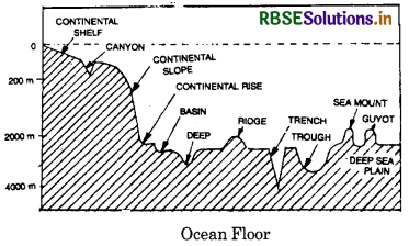
3. Deep Sea Plain. Beyond the continental slope, the broad undulating plain is known as deep sea plain or Abyssal plain. It covers about 77% area of the oceans were: Its maximum extent is 80.3% in Pacific Ocean. It is uniformally flat with a gradient less than 1/1000. This plain has many submarine features like ridges, sea mounts, islands, volcanoes etc. Its average depth is between 3000 to 6000 metres covered with sediments.
4. Ocean deeps. These are the deepest parts of the oceans were: It consists of long narrow trenches known as ocean deeps. These cover only 2% of the oceanic area and occupy small areas. These have depths of more than 6000 metres. There are about 57 deeps in the world out of which 32 are in Pacific Ocean, 19 in Atlantic Ocean and 6 in Indian Ocean. The deepest trench in the world is Mariana trench in the Pacific with a depth of 11022 metres. The ocean deeps have the following characteristics:
- These are found along the continental margins and not in the midst of oceans were:
- Most of the trenches are found along the island arches.
- The trenches are closely related to earthquakes and volcanoes.
Question 2.
Discuss “Oceans are future storehouse of Resources.”
Answer:
Importance of OceAnswer: The oceans affect the coastal areas directly, but indirectly oceans are very useful for mankind. Oceans modify climate. Ocean currents affect the distribution of temperature and humidity. Tidal energy is generated from Tides. Oceans are the most important, cheapest and natural means of transport. Oceans are storehouse of food for growing population. Therefore ocean have rightly been ‘future storehouse of Resources’.
(i) Oceans and Climate : Oceans exert a great influence upon the climate. Oceans act as a saving bank for the solar energy. Oceans affect the temperature and humidity. The range of temperature is low in coastal areas. Two types of climate-continental and maritime results due to land and oceans contrasts. Ocean currents modify the temperature of coastal areas. The atmosphere derives moisture from the oceans were: Rainfall is the gift of oceans were:
(ii) Oceans and Food Resources. The primitive man was dependent on the oceans for fish. Nowadays oceans are the storehouse of fish. It has inexhaustible resources. Fish now make up more than 10 per cent of the total animal protein food that man consumes. Refrigeration has helped the modern fishing. Man is increasingly depending upon ocean for food and other useful things.
(iii) Oceans and Mineral Resources. Oceans are a storehouse of a large number of useful metallic and non-metallic minerals. These minerals occur both in solution and in suspension. Salt is the most important mineral in saline water. Other minerals include mang¬anese, phosphorite, sulphur, titanium, monozite, gold, iron, sand, etc. Some minerals are renewed in oceans were:
(iv) Oceans and petroleum. The most important minerals produced from the sea are petroleum and gas. Petroleum is found in off-shore regions on the continental shelf and shallow basins. 20% of the world’s total reserves are found in off-shore waters. More than 75 countries are exploring oil in such areas. Mumbai High is an important offshore oil region of India, located at a distance of 150 kms from the coasts. Present oil reserves will last for only 50 years. It is estimated that 40% of world’s oil production will come from the oceans were:
(v) Oceans and energy. The energy resources of the ocean come in various forms; tidal force, geothermal energy, and energy from ocean temperature differences. Tidal energy is due to tides. A few tidal power stations are working in Russia, France and Japan. Floating generators have been designed to produce power from the difference in ocean temperatures in Belgium and Cuba, Geo-thermal energy is produced from the active volcanoes in the U.S.A., Mexico, New Zealand.
(vi) Ocean transportation and trade. Ocean is the most important means of natural transport. It is an invaluable link among the continents. Oceans provide the easiest and the cheapest means of transport. The oceans as a highway has proved a boon for the international trade. The future use of ocean depends in keeping oceans free from pollution. Oceans are becoming a source of disputes among super-powers. It is required to keep the oceans free from all disputes and maintain peace.
Question 3.
Describe the factors which control the MM amount and distribution of salinity in: different oceAnswer:
Answer:
Sea water is always saline, but the degree of salinity is not everywhere the same. The average salinity of the oceans is 35% or about 35 parts of salts in 1000 parts of water.
1. The Rate of evaporation. Salinity is directly related to the rate of evaporation. The rate of evaporation increases with high temperatures, strong winds, less rainy days and low humidity. Within tropics salinity is high due to high temperature. The temperate oceans have low salinity due to low temperatures.
2. Supply of fresh water. Supply of fresh water reduces the salinity. The amount of fresh water is added by rainfall, melting of ice and large rivers. The salinity is low in equatorial regions due to heavy rainfall. Near the mouths of large rivers like Amazon, Zaire, Niger, low salinity is found. Low salinity is found in North Sea and Baltic Sea, because much fresh water is added from the melting of ice.
3. Mixing of water. There is free mixing of water in open seas due to movements of water by currents, waves and tides. It reduces the salinity locally. In wholly or partially enclosed seas such as the Caspian Sea, Mediterranean Sea, water does not mix freely with ocean water and high salinity is found. In areas of inland drainage or lakes, salts, accumulate and increase the salinity.
4. Atmospheric Pressure and winds. Warm and dry winds increase the rate of evaporation and salinity. In areas of high pressure, descending winds increase the evaporation due to which salinity is high.
5. Movements of sea water. Ocean currents, waves, and tides increase or reduce the local salinity by
mixing of water. Salinity, temperature and density of water are interrelated. Any change in temperature or density influences salinity of an area.
Question 4.
What do you mean by salinity of oceans? Describe the distribution of salinity in different oceans?
Answer:
Salinity. Sea water contains large amount of salts in solution. The degree of saltness of water is known as salinity. It is expressed as a percentage or as parts per thousand. Salinity is the ratio between the weight of the dissolved material and the total weight of the sea water. The average salinity of the oceans is 35%. It means that on an average every 1000 gms. of sea water contains about 35 gms. of salt. The degree of saltness varies in different oceans, but the proportions of different salts remain constant in all oceAnswer: Sodium chloride (77.7 per cent) is the most abundant salt. Sea water also contains compounds of calcium, magnesium and potassium.
Distribution of salinity.
Distribution of salinity depends upon evaporation, supply of fresh water and mixing of water by surface and sub-surface currents. The upper limit of salinity in brackish water is 24.7%.
1. Salinity in open seas. In open seas, the differences in salinity are relatively small. (33% to 37%).
(a) Near the Equator. Salinity is below average (34%) near the equator. Reasons.
- Heavy rainfall
- Greater cloudiness.
- High relative humidity
- Calm air.
- Low rate of evaporation,
- Large supply of fresh water by rivers like Amazon, Niger, Zaire etc.
(b) Near the tropics. The area of the highest (37%) salinity lies near the tropics.
Reasons.
- High evaporation due to clear skies and high temperatures,
- Dry trade winds
- Low rainfall.
- Absence of big rivers. In hot and dry regions it reaches 70%.
(c) Near the Poles. In polar areas, the salinity decreases to 20% to 30%. In Arctic sea it is 0-35%. But North Sea has a high salinity due to north Atlantic drift.
Reasons
- Low evaporation due to cold air.
- Large supply of fresh water by rivers.
- Melting of snow and icebergs,
- More rainfall due to westerlies.
2. Salinity in wholly or partially enclosed seas. Variation of salinity is well marked in wholly or partially enclosed seas.
(a) Mediterranean Sea has a high salinity (39%). In Red Sea salinity exceeds 40%, the Suez Gulf (41%) and the Persian Gulf (38%) have salinity above the average.
Reasons.
- Rapid evaporation,
- Dry summers.
- Absence of big rivers,
- Dry air.
- Cloudless skies.
- In Black Sea, the salinity is 18%.
Baltic Sea has an average salinity of 7% and drops to a very low of 2%. Dut to influx of fresh water. Bay of Bengal has low salinity due to high fresh supply of water, but Arabian Sea has high salinity due to low intent of water.
Reasons.
- Less evaporation due to low temperature.
- Large supply of water due to many rivers
- Melting of snow
- A number of big rivers like Danube, Dniester, Dnierper and Don flowing into Black Sea.
3. Salinity in lakes and inland seas. The salinity in inland seas and lakes is very high. Salinity is in those enclosed seas in which rivers bring a large supply of fresh water. Northern part of Caspian Sea has a low salinity of 13% due to river Volga, but it is 170% in Gulf of Kara-Bogaz. The Salt Lake (U.S.A.) has a salinity of 220%. The highest salinity is found in Lake Van (Turkey) with 330%. The Dead Sea has a salinity of 238%. The density of water is so high that it is impossible to sink in Dead Sea. The salt lakes are becoming more salty with the passage of time.
Reasons for high salinity
- High temperature.
- Rate of evaporation is high,
- Accumulation of salt due to evaporation
- Absence of an outlet.
Question 5.
Describe the vertical and horizontal distribution of temperature in the oceans were:
Answer:
The temperature of the oceans were: The temperatures of the oceans influence the climate of the coastal areas, movements of the oceans water, sea organisms and atmospheric circulation. Horizontal distribution of temperature. The following are the main characteristics of the distribution of surface temperature of the oceans :
1. The temperature of the surface water is not the same everywhere. The temperature of ocean water decreases away from the equator. The annual average temperature at different latitudes is as under :
At equator -27°C
At 20° latitudes -22°C
At 40° latitudes -14°C
At 70° latitudes-5°C
The rate of decrease of temperature with increasing latitude is generally 0.5°C per latitude.
2. The highest temperatures are found in the enclosed tropical seas. For example, the average summer temperature of the surface water of the Red Sea is 30°C. The highest temperature is not received at the equator but slightly towards north of it.
3. The 0°C (32°C) isotherm forms a rough circle round the polar areas, moving towards equator during the winter.
Vertical distribution of temperature :
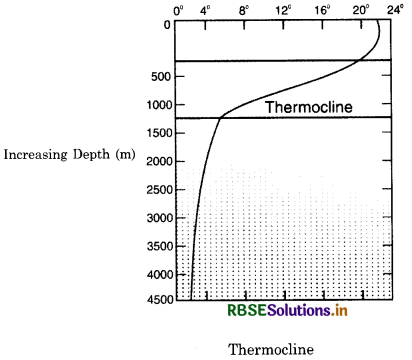
2. The rate of decrease of temperatures is not equal at all depths. Upto a depth of 100 metres, there is no change in temperature. Up to a depth of 1800 metres, the temperature decreases from 15°C to 2°C. Between 1800 and 4000 metres, the temperature decreases from 2°C to 1,6°C. At lower depths the rate of decrease becomes very slow. The boundary region from where there is a rapid decrease of temperature it is called thermocline. 90% of water is found below thermocline. In this zone temprature reaches 0°C.
3. The rate of decrease of temperature is greater at the equator than at the poles.
4. Partially enclosed seas, separated by Submarine ridges, have different temperatures from those in the open seas. For example, the Red Sea has a temperature of 21°C at a depth of 1200 fathoms; but in the open waters of the Indian Ocean the temperature at a depth of 1200 fathoms is 1.7°C only.
Source Based Questions
1. Read the following paragraph and answer the questions given below:
Sea water contains large amount of salts in solution. The degree of saltness of water, is known as salinity. It is expressed as a percentage or as parts per thousand. Salinity is the ratio between the weight of the dissolved material and the total weight of the sea water. The average salinity of the oceans in 35%. It means that on an average every 1000 gm. of sea water oceans contains about 35 gm. of salt. The degree of saltness varies in different oceans, but the proportions of different salts remains constant in all oceans were Sodium chloride is the most abundant salt. Sea water also contains compounds of calcium, magnesium and potassium.
(i) Which of the following contains large amount of salinity?
(a) Seawater
(b) Well
(c) Pound
(d) None of these
Answer:
(a) Seawater
(ii) How is salinity expressed?
(a) gm
(b) Percentage
(c) Per thousand
(d) Both (b) and (c)
Answer:
(d) Both (b) and (c)
(iii) What is the average salinity of the oceans?
(a) 30%
(b) 35%
(c) 40%
(d) 45%
Answer:
(b) 35%
(iv) Which of the following compounds are present in seawater?
(a) Calcium
(b) Magnesium
(c) Potassium
(d) All of these
Answer: (d) All of these
2. Read the following paragraph and answer the questions given below:
Continental shelf is a shallow zone around a continent from the shoreline to the continental edge, with an average depth of 1000 fathom. It is thus a shallow platform submerged underwater. The continental shelf covers about 7.5 % of total area of the oceans were: It has the maximum extent in the Atlantic Ocean. It has an average width of 80 kms. It is absent along the coast of Chile at an average depth of 30 metres. Some shelves are 600 metres deep. It extends to over 1500 km. around the coast of Arctic oceans were: Narrow shelves are found along the coasts having high mountains. The mean slope of the shelf is less than one degree.
(i) Which of the following is a shallow zone around a continent?
(a) Deep sea plain
(b) Continental slope
(c) Continental shelf
(d) None of these
Answer:
(c) Continental shelf
(ii) What is an average depth of continental shelf?
(a) 100 fathom
(b) 200 fathom
(c) 150 fathom
(d) 250 fathom
Answer:
(a) 100 fathom
(iii) How much area of the ocean is covered by the continental shelf?
(a) 7.1%
(b) 7.2%
(c) 7.5 %
(d) 7.8 %
Answer:
(c) 7.5 %
(iv) Where does the continental shelf has the maximum extent?
(a) Pacific Ocean
(b) Indian Ocean
(c) Atlantic Ocean
(d) Arctic Ocean
Answer:
(c) Atlantic Ocean
SELF EVALUATION TEST
- Which is the deepest ocean deep of the world?
- What is alyssal plain?
- Name an important ocean truth.
- Name an important submarine.
- What is Hydrosphere?
- What is continental shelf?
- What is antipodal position?
- Why is earth called a blue planet?
- State the various uses of oceans were:
- On what factors does the distribution of salinity depend?

- RBSE Solutions for Class 12 Geography Chapter 11 अंतर्राष्ट्रीय व्यापार
- RBSE Solutions for Class 11 Geography Chapter 1 भारत - स्थिति
- RBSE Solutions for Class 11 Geography Chapter 3 पृथ्वी की आंतरिक संरचना
- RBSE Solutions for Class 8 Our Rajasthan Chapter 5 उद्योग
- RBSE Solutions for Class 11 Geography Chapter 2 संरचना तथा भूआकृति विज्ञान
- RBSE Solutions for Class 11 Geography Chapter 1 भूगोल एक विषय के रूप में
- RBSE Class 11 Geography Important Questions Chapter 7 Natural Hazards and Disasters
- RBSE Class 11 Geography Important Questions in Hindi & English Medium
- RBSE Class 11 Geography Important Questions Chapter 6 Soils
- RBSE Class 11 Geography Important Questions Chapter 5 Natural Vegetation
- RBSE Class 11 Geography Important Questions Chapter 4 Climate