RBSE Class 11 Geography Important Questions Chapter 10 Atmospheric Circulation and Weather Systems
Rajasthan Board RBSE Class 11 Geography Important Questions Chapter 10 Atmospheric Circulation and Weather Systems Important Questions and Answers.
Rajasthan Board RBSE Solutions for Class 11 Geography in Hindi Medium & English Medium are part of RBSE Solutions for Class 11. Students can also read RBSE Class 11 Geography Important Questions for exam preparation. Students can also go through RBSE Class 11 Geography Notes to understand and remember the concepts easily.
RBSE Class 11 Geography Important Questions Chapter 10 Atmospheric Circulation and Weather Systems
Multiple Choice Questions
1. The atmospheric pressure per cm at sea
(A) 0.5 kg
(B) 1.0 kg
(C) 1.03 kg
(D) 1.5 kg.
Answer:
(C) 1.03 kg

2. What is the causes of low pressure at 60° latitudes?
(A) Rotation
(B) High temperature
(C) Centrifugal free
(D) Cold currents.
Answer:
(A) Rotation
3. The extent of Doldrums is
(A) 5° N-5° S
(B) 30°-35° N
(C) 60°-65° N
(D) 60°-65° S.
Answer:
(A) 5° N-5° S
4. The winds blowing eastward crossing Rockies
(A) Foehn
(B) Chinook
(C) Mistral
(D) Bora.
Answer:
(B) Chinook
5. The cyclones in China sea are
(A) Typhoons
(B) Hurricanes
(C) Willy-Willy
(D) Tornadoes.
Answer:
(A) Typhoons
6. The region getting winter rainfall
(A) Equatorial
(B) Mediterranean
(C) Monsoon
(D) Savana.
Answer:
(B) Mediterranean
7. What is the normal pressure?
(A) 34 millibars
(B) 300 millibars
(C) 1013 millibars
(D) 1900 millibars.
Answer:
(C) 1013 millibars
8. Which area is called Doldrums?
(A) Equatorial Region
(B) Polar Region
(C) Temperate Tropical Region
(D) Cold Tropical Region.
Answer:
(A) Equatorial Region
9. What is the direction of trading winds in the Northern Hemisphere?
(A) North-eastern
(B) South-eastern
(C) Western
(D) Southern.
Answer:
(A) North-eastern
10. A unit for measring atmorpheric pressure is
(A) Milibar
(B) Calories
(C) Meter
(D) Cm.
Answer:
(A) Milibar
Very Short Answer Type Questions
Question 1.
What is the rate of decrease of atmospheric pressure with altitude?
Answer:
12 millibars per 100 metres or one inch for 300 metres.
Question 2.
Name the factors on which the pressure of a place depends.
Answer:
- Temperature
- Altitude
- Water vapour
- Rotation.

Question 3.
What is normal pressure?
Answer:
29.92 inches or 76 cms or 1013.2 millibars.
Question 4.
What is a millibar?
Answer:
A force equal to 1000 dynes per sq cm.
Question 5.
What are isobars?
Answer:
Lines of equal pressure.
Question 6.
Name the equatorial low-pressure belt.
Answer:
Doldrums.
Question 7.
Name the sub-tropical high-pressure belt.
Answer:
Horse latitudes.
Question 8.
Name the belts of calm.
Answer:
Doldrums.
Question 9.
What are planetary winds?
Answer:
Permanent winds which blow throughout the year in the same direction.
Question 10.
Name the force generated by the rotation of the earth.
Answer:
Coriolis force.
Question 11.
Name a natural region which gets rainfall in winter due to westerlies.
Answer:
Mediterranean region.
Question 12.
What term is used for westerlies in 40°-50° South latitudes?
Answer:
Roaring forties.
Question 13.
Name the winds which blow over prairies after descending the rocky mountains.
Answer:
Chinooks.
Question 14.
Name the winds which blow over Switzerland after descending the Alps.
Answer:
Foehn winds.
Question 15.
What are Anabatic winds?
Answer:
Valley winds.
Question 16.
What are Katabatic winds?
Answer:
Mountain winds.
Question 17.
Which winds are called ‘Snow eaters’?
Answer:
Chinook winds.
Question 18.
From which word the term monsoon has been derived?
Answer:
From Arabic word ‘Mausam’.
Question 19.
Name two types of atmospheric disturbances.
Answer:
Cyclones and Anticyclones.

Question 20.
Name two types of cyclones.
Answer:
Tropical and temperate.
Short Answer Type Questions
Question 1.
Explain why the trades in northern hemisphere have north-easterly direction.
Answer:
These winds blow as N. E. trades in the northern hemisphere. These winds are deflected from their North-South direction. This deflection force of the earth’s rotation is known as Coriolis force. This force forms the basis of Ferral’s law. According to Ferral’s law, all moving bodies are deflected to the right in the northern hemisphere. Therefore, the trade winds, after deflection to the right, become N.E. trade winds.
Question 2.
“Most of the hot deserts of the world lie on the western margins of the continents”. Why?
Answer:
Deserts are areas of low rainfall. Hot deserts lie in the trade wind belt. These winds give rain on the eastern margins, but trade winds get dry as these reach western margins. These are offshore winds. So these are known as Trade wind deserts such as Atacama, Kalahari, Sahara etc.
Question 3.
“Despite its location in higher latitudes; low pressure is found in sub-polar area”. Why?
Answer:
Sub-polar area has low temperatures, but a high pressure exists due to the rotation of the earth. It causes a centrifugal force which displaces the air outwardly. The air becomes so thin that there is no effect of low temperature on the pressure.
Question 4.
In what ways the general circulation of atmosphere affects the movement of oceanic! waters? What is ENSO
Answer:
The general circulation of the atmosphere also affects the oceAnswer: The large-scale winds of the atmosphere initiate large and slow moving currents of the ocean. Oceans in turn provide input of energy and water vapour into the air. These interactions take place rather slowly over a large part of the ocean. The most important is the warming and cooling of Pacific Ocean. The warm water of the central Pacific Ocean slowly drifts towards South American coast and replaces the cool Peruvian current. Such appearance of warm water off the coast of Peru is known as the El Nino.
The El Nino event is closely associated with the pressure changes in the Central Pacific and Australia. This change in pressure condition over Pacific is known as the southern oscillation. The combined phenomenon of southern oscillation and El Nino is known as ENSO. In the years when the ENSO is strong, large-scale variations in weather occur over the world. The arid west coast of South America receives heavy rainfall, drought occurs in Australia and sometimes in India and floods in China. This phenomenon is closely monitored and is used for long range forecasting in major parts of the world.
Question 5.
What do you mean by atmospheric pressure?
Answer:
Air has weight. The atmosphere is held to the earth due to gravitational pull of the earth. It exerts its weight as pressure on the earth’s surface. It is the weight of column of air extending from the ground to the outermost layer of the atmosphere. This is known as atmospheric pressure. At this rate, the atmospheric pressure on each of us weighs nearly one tonne.
Question 6.
Explain the relation between pressure and temperature.
Answer:
The atmospheric pressure has an inverse relation with temperature. As the air is heated, it expands and rises upwards. The higher the temperature, the lower is the pressure. On the other hand, cold air contracts and becomes heavy. It results in high pressure. The general rule is that a rising thermometer shows a falling barometer, whereas a falling thermometer shows a rising barometer.
Question 7.
Why does the pressure decrease with altitude? Explain the relation between altitude of a place and atmospheric pressure.
Answer:
There is an inverse relation between pressure and altitude. There is a rapid decrease of pressure with increasing height. The pressure decreases at the rate of 12 mb. for every 300 metres. The lower layers are denser than upper layers. The lower layers are compressed under the weight of the upper layers of the atmosphere. It is estimated that about one-half of the atmospheric pressure lies up to a height of 5 km.
Question 8.
Name the different areas of tropical cyclones.
Answer:
There are different kinds of tropical cyclones. These are known by different names in different oceans such as-
- Depressions in Bay of Bengal.
- Hurricanes in West Indies.
- Typhoons in China Sea.
- Tornadoes in Atlantic ocean.
- Willy-willy in Australia.

Question 9.
Define the pressure gradient.
Answer:
Atmospheric pressure is shown by isobars. The spacing between isobars shows pressure gradient. Close spacing represents a steep gradient while wide spacing shows a gentle gradient. Thus the pressure gradient is rate at which the horizontal pressure changes. It is always measured at right angles to the isobars. When the pressure gradient is steep, strong winds blow. When the pressure gradient is weak, gentle winds blow. Thus the pressure gradient is defined as the change in pressure per unit distance.
Question 10.
What are local winds? Name their different types. Name one country each where these winds blow.
Answer:
Some winds of special characteristics result in different areas under local conditions. These are called local winds.
Types of local winds :
- Hot winds-Chinook in Canada, Foehn in Switzerland.
- Dry winds-Sirocco in Southern Europe, Khamsin in Egypt, Harmatten in West Africa; Simoom of Arabia,Santa Anna of California, Zenda of Argentina.
- Cold winds-Boro and Mistral in Southern Europe, Pampero in Argentina, Buran in Siberia.
Question 11.
What do you mean by “Roaring forties?”
Answer:
Westerlies are best developed in the southern hemisphere due to vast expanse of oceans westerlies blow here strongly and regularly throughout the year. These are a menace to shipping along cape horn route. These brave west winds are known as ‘roaring forties’ between 40° and 50° South latitudes.
Question 12.
What is Jet Stream?
Answer:
The high velocity winds blowing at high altitudes are called Jet Stream. This strong current of air is located near 30° North latitude. It affects weather pattern of the world. High flying planes use these as ‘super tail winds’ to save time and fuel.
Question 13.
What are isobars? Why are these reduced to sea level?
Answer:
Isobars:
Isobar is combination of two words (Iso = equal, Bar -pressure). So isobars are lines of equal pressure.
Isobar is an imaginary line joining the places of equal pressure reduced to sea level. Pressure is reduced to sea level to eliminate the effects of altitude. If a place is 300 metres high and its actual pressure is 900 millibars, its pressure reduced to sea level would be 900 + 34 = 934 millibars because the pressure decreases at the rate of 34 millibars for every 300 metres. Isobars generally run in east-west direction.
Question 14.
Explain Ferral’s law with the help of a diagram.
Answer:
The deflective force of the earth’s rotation is known as Coriolis force. All moving bodies are deflected to the right in the northern hemisphere and to the left in the southern hemisphere. This is known as Ferral’s
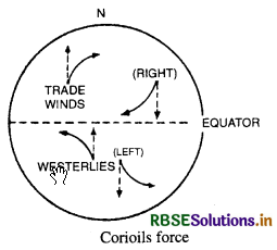
law. In the Northern hemisphere, trade winds become N.E. trade winds; westerlies are deflected to their right as S. W. westerlies. In the Southern hemisphere, trade winds are deflected to their left as S. E. trade winds, while westerlies become N. W. westerlies.
Question 15.
Describe the different types of fronts. ;
Answer:
Fronts :
When two different air masses meet, the boundary zone is called a front. There are four types of fronts:
- Cold
- Warm
- Stationary, and
- Occluded front.
When the front remains stationary, it is called stationary front. When the cold air moves towards warm air-mass, its contact zoneis called the cold front, whereas if warm air-mass moves towards cold air-mass, the contact is a warm front. If an air mass is fully lifted above the land surface, it is called the occluded front. Fronts occur in middle latitudes and are characterised by steep gradient in temperature and pressure. They bring in abrupt changes in temperature and cause the air to rise to form clouds and precipitation.
Comparison Questions
Question 1.
Compare and contrast the tropical cyclones and temperate cyclones.
Answer:
|
Tropical cyclones |
Temperate cyclones |
|
1. Location. The Tropical cyclones occur between 5° and 30° latitudes within the tropics. |
1. Temperate cyclones are found in temperate region between 350 and 65° latitudes. |
|
2. Direction. The tropical cyclones move along with trade winds from east to |
2. Temperate cyclones move along with westerlies from 1 west to east. |
|
3. SizeThese cyclones cover a small area with a diameter between 150 to 500 km. |
3. These are extensive and have a vertical thickness from 9 to 1 km and a di ameter of about 1000 km. |
|
4. Shape. These are circular and symmetrical in shape. |
4. These are generally cir cular or elongated troughs. |
|
5. Origin. Tropical cyclones are thermal in origin and develop due to local convection currents. |
5. These are frontal in ori gin and develop due to meeting of warm, tropi cal and cold polar air mass. |
|
6. Weather. The sky is overcast with violent winds and heavy rainfall. The stormy weather lasts for some hours. |
6. The weather is variable with cold air, extensive clouds. Rainfall is slow and lasts for many days. |

Question 2.
Distinguish between cyclones and anti- J cyclones.
Answer:
|
1. A cycione is a centre of low pressure surrounded by high pressure on all sides. |
1. Anti-cyclone is a centre of high pressure sur rounded by low pressure on all sides. |
|
2. A cyclone has a converging system of winds which tend to blow towards the centre. |
2. An anit.cyclone has a diverging system of winds radiating from the centre. |
|
3. Winds blow anti-clock wise in the northern hemisphere and clock wise in the southern hemisphere. |
3. Winds blow in a clock wise direction in the northern hemisphere and anti-clockwise in the southern hemi sphere. |
|
4. Cyclones are of two types-temperate and tropical cyclones. |
4. Anti-cyclones are of two types-cold and warm. |
Question 3.
Draw labelled diagrams to explain :
(i) Land and sea breezes.
(ii) Mountain and valley winds.
(iii) Chinook and Foehn winds.
Answer:
(i) Land and sea breezes.
(a) Sea Breeze-During the day time, the land gets rapidly heated up than the sea. The warm air rises forming a low pressure locally on land. The sea being cooler develops a high pressure. So a cool sea breeze blows from sea to land. Sea breeze moderates the temperature of the coastal areas resulting in an equable or maritime climate.
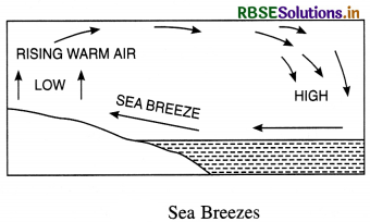
(b) Land Breeze. During the night the land becomes cooler than the sea. The cold and heavy air produces a local high pressure on land.
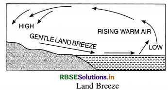
The sea remains comparatively warmer with a low pressure. Therefore, a land breeze blows from land to sea.
(ii) Mountain and valley winds.
(a) Mountain winds. In hilly areas, cold and dense air blowing down-valley slope during the night are called mountain winds. It is known as air-drainage or Kata-batic winds.
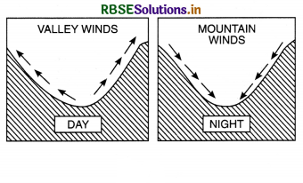
(b) Valley winds-In hilly areas, the warm winds ascending up the valley slopes during the day, are called valley winds. These ascending winds are known as valley winds or Anabatic winds.
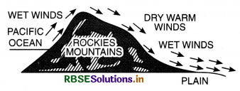
(iii) Chinook and Foehn winds.
(a) Chinook winds. Chinook winds are experienced on the eastern slopes on the Rockies and prairies in U.S.A. and Canada. The westerlies after crossing the rockies are known as Chinook winds. They raise the temperature of the area by 15° C to 20°C in a couple of hours. Chinook means ‘a snow eater’ as it melts snow rapidly under its influence.
(b) Foehn winds. Foehn is a warm dry wind blowing across the Alps down the valleys in Switzerland in spring. It melts snow rapidly and hastens the growth of crops. These winds make the winters mild.
Essay Type Questions
Question 1.
What are trade winds and Westerlies? How are these caused? Describe their extent direction and effects. !
Answer:
Planetary Winds. The pattern of distribution of pressure belt is almost permanent on the globe. Winds blow constantly from the high-pressure belts to low-pressure belts. These winds are permanent winds which blow throughout the year and are known as planetary winds. These winds are of three types :
- Trade winds
- Westerlies
- Polar winds.
1. Trade Winds :
Extent. Trade winds are those steady winds which
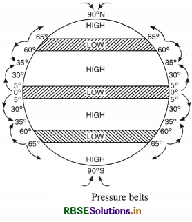
blow within tropics, from the sub-tropical high pressure towards the equatorial low. These winds cover roughly a zone between 5°-35° North and South latitudes. Direction. In both the hemispheres, these winds tend to blow from East. So these are also termed as Easterlies. In the northern hemisphere, they blow from North-East, while in the Southern hemisphere they blow from South-East. Why so called? These winds are called trade winds due to the following reasons :

(i) These winds were helpful as backing winds to sailing ships. These were thus helpful to early traders; hence the name trade winds.
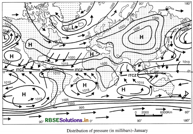
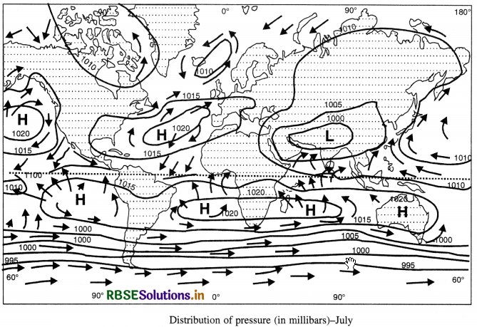
(ii) The phrase ‘to blow trade’means to blow steadily in a constant direction. As the trade winds are most regular of all the planetary winds, these are known as trade winds or track winds. Cause of origin. Due to intense heating, air rises upwards as convection currents, resulting in equatorial low pressure. This rising air moves poleward; but descends in the subtropics to form a high pressure belts. So the winds blow from the sub-tropical high pressure towards the Equatorial low as trade winds. Change in direction. Winds do not blow in a North- South direction. Earth’s rotation, and the Coriolis Force deflect the direction of winds. This is known as Ferral’s law of deflection. According to this, winds are deflected to their right in the northern hemisphere and to their left in the southern hemisphere.
Effects:
- As trade winds blow from cooler areas to warmer areas, these are generally dry winds.
- These winds gather moisture from the oceans and are on-shore on the east coast of continents giving heavy rainfall.
- Trade winds are off-shore on the west coasts. That is why hot deserts (Trade wind deserts) are found between 20°-30° latitudes on the western margins of the continents.
- The poleward parts of trade winds are cool and dry; but equatorward these become warm and wet.
- These winds are steady and regular. These blow with a great force and in a constant direction over oceans
2. Westerlies :
Extent. The westerlies blow, within the temperate region, from the sub-tropical high pressure towards the sub-polar low pressure. These winds cover roughly a zone between 35°- 60° North and South latitudes. Their northern limit is variable due to polar fronts and cyclones. Direction. These winds tend to blow from west and are termed as westerlies. As their direction is opposite to the trade winds, these are also called anti-trade winds. In the Northern hemisphere, these blow from South West. Cause of origin.
A high pressure is developed along the tropics (horse latitudes) due to descending winds. Due to rotation and centrifugal force, a sub-polar low pressure is developed along Arctic and Antarctic circles. So the westerlies blow from sub-tropical high pressure towards sub-polar low pressure between 35°-60° latitudes. Change in direction. Due to rotation and coriolis force, these winds are deflected away from North-South direction. According to Ferral’s law. these become South- Westerlies in the Northern hemisphere and North- Westerlies in the Southern hemisphere.
Effects:
(i) These winds are on-shore winds on the western coasts of continents and bring much precipitation. But the eastern parts remain comparatively dry.
(ii) These winds are variable in strength and direction. Cyclones and anticyclones produce an uncertain weather. The weather is changing due to clouds, fog, gales and snowfall.
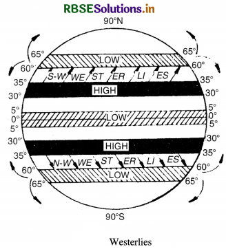
(iii) The westerlies blow uninterruptedly with much greater force and regularly throughout the year. These are best developed in the southern hemisphere due to large expanse of oceAnswer: Here these are termed as brave west winds, roaring forties, furious fifties and shrieking sixties. These stormy winds are a menace to shipping along Cape Horn route.

(iv) These winds bring winter rainfall in many parts of the Mediterranean Region.
Question 2.
What is ITCZ? Distinguish between Hadley cell and Ferral cell. (TBQ)
Answer:
The air at the ITCZ rises because of convection caused by high insolation and a low pressure is created. To this low pressure the winds from the tropics, the easterlies, converge. The converged air also rises along with the convective cell. It reaches the top of the troposphere up to an altitude of 14 km. and moves towards the north and south poles. This causes accumulation of air at about 30°N and S. Part of the accumulated air sinks to the ground and forms subtropical high. Another reason for sinking is the cooling of air when it reaches 30° N and S latitudes. Down below near the land surface the air flows towards the equator as the easterlies.
The easterlies from either side of the equator converge in the Inter Tropical Convergence Zone (ITCZ). Such circulations are called cells. The cell in the tropics is called a Hadley Cell. In the middle latitudes the circulation is that of sinking cold air that comes from the poles and the rising warm air that blows from the subtropical high. At the surface the winds are predominantly westerlies. This cell is known as the Ferral Cell. At polar latitudes the cold dense air subsides near the poles and blows towards middle latitudes as the polar easterlies. This cell is called the Polar Cell.
Question 3.
What do you mean by atmospheric pressure? On what factors does it depend?
Answer:
Atmospheric Pressure. Air has a weight of about 1.2 ounce per cubic foot of air. The atmosphere is held to the earth due to gravitational pull of the earth. It exerts its weight as pressure on the earth’s surface. It is the weight of column of air extending from the ground to the outermost layers of the atmosphere. This pressure is known as atmospheric pressure. The atmospheric pressure is measured in terms of the height of a column of mercury in a barometer. The normal pressure at sea level at 45° latitude is 29.92 inches or 76 cms.
or 1013.2 millibars.The atmospheric pressure is expressed in units of millibars. Factors. The atmospheric pressure varies from place to place and time to time due to the following factors : 1. Temperature. As the air is heated, it expands and rises upwards. On the other hand, cold air contracts and becomes heavier. Thus pressure has an inverse relation with temperature. The higher the temperature, the lower is the pressure. The general rule is that a rising thermometer shows a falling barometer, whereas a falling thermometer shows a raising barometer.
2. Altitude. There is a rapid decrease of pressure with increasing height. The pressure decreases at the rate of one inch or 34 millibars for every 300 metres. The pressure decreases with height. The decrease amounts tol mb for each 10 metres. The lower layers are denser than upper layers. Moreover, the lower layers are compressed under the weight of the upper layers of the atmosphere. It is estimated that about one half of the atmosphere lies upto a height of 5 km.
3. Water Vapour. Water vapour is lighter than air. Therefore, dry air is heavier than wet air. Due to this reason, land winds are heavier than sea winds which are laden with water vapour.
4. Rotation. The rotation of the earth and centrifugal force result in swing of air in different areas. The sub-polar low pressure along 60° latitudes is due to the rotation of the earth.
Source Based Questions
1. Read the following paragraph and answer the questions given below:
The speed and direction of the wind are the net result of the wind generating forces. The winds in the upper atmosphere, 2 to 3 kilometre above the surface, are free from frictional effect of the surface and are controlled by pressure gradient and the Coriolis force. When isobars are straight, as there is no friction, the pressure gradient force is balanced by the Coriolis force and the resultant wind blows parallel to the isobar. These winds as known as the geotropic winds.
(i) Which force is the net result of the speed
and direction of the wind?
(a) Wind generating force
(b) Local winds
(c) Trade winds
(d) All of these
Answer:
(a) Wind-generating force
(ii) When isobars are straight, the pressure gradient force is balanced by which force?
(a) Gravitational force
(b) Wind-generating force
(c) Coriolis force
(d) All of these
Answer:
(c) Coriolis force
(iii) Geotropic winds are also called
(a) Gravitational force
(b) Coriolis force
(c) Wind generating force
(d) All of these
Answer:
(b) Coriolis force
2. Read the following paragraph and answer the questions given below:
Tropical cyclones originate and intensify over warm tropical oceans were: The conditions favourable for the formation and intensification of tropical storms are large sea surfaces with temperatures higher than 27°C the pressure of the Coriolis force; small variations in the vertical wind speed a pre-existing weak low-pressure area or low-level cyclonic circulation upper divergence above the sea level system.
Tropical cyclones are violent storms that originate over oceans in tropical areas and move over to the coastal areas bringing about large-scale destruction caused by violent winds, very heavy rainfall and storm surges. This is one of the most devastating natural calamities. They are known as cyclones in the Indian Oceans, hurricanes in the Atlantic, typhoons in the western Pacific and South China sea and willy-willies in the western Australia.
(i) The cyclones in China sea are known as:
(a) Typhoons
(b) Hurricanes
(c) Willy willy
(d) Tornadoes
Answer:
(a) Typhoons

(ii) Where do tropical cyclones originate?
(a) Warm tropical oceans
(b) Cold tropical oceans
(c) Both (a) and (b)
(d) None of these
Answer:
(a) Warm tropical oceans
(iii) What is the favourable condition for the formation and intensification of tropical storms?
(a) Large sea surface with temperature higher than 27°C
(b) Presence of Coriolis force
(c) Upper divergence above the sea level
(d) All of these
Answer:
(d) All of these
HOTS QUESTIONS
Question 1
What are the effects of atmospheric pressure?
Answer:
- Atmospheric pressure determines when the air will rise or sink.
- The wind redistributes the heat and moisture across the planet thereby maintaining a constant temperature for the planet as a whole.
- The vertical rising of air facilitates the formation of clouds and precipitation, which replenishes the fresh water over the land.
- As we climb upward, the air becomes thin and there is problem of breathing.
SELF EVALUATION TEST
- What is the relation between pressure and temperature?
- What is normal pressure?
- Name two belts of calm.
- What are isobars?
- Name two types of cyclones.
- What are land and sea breeze?
- What are roaring forties?
- What is a Jet stream?
- Explain Ferral’s law.
- On what factors does the atmospheric pressure depend?

- RBSE Solutions for Class 12 Geography Chapter 11 अंतर्राष्ट्रीय व्यापार
- RBSE Solutions for Class 11 Geography Chapter 1 भारत - स्थिति
- RBSE Solutions for Class 11 Geography Chapter 3 पृथ्वी की आंतरिक संरचना
- RBSE Solutions for Class 8 Our Rajasthan Chapter 5 उद्योग
- RBSE Solutions for Class 11 Geography Chapter 2 संरचना तथा भूआकृति विज्ञान
- RBSE Solutions for Class 11 Geography Chapter 1 भूगोल एक विषय के रूप में
- RBSE Class 11 Geography Important Questions Chapter 7 Natural Hazards and Disasters
- RBSE Class 11 Geography Important Questions in Hindi & English Medium
- RBSE Class 11 Geography Important Questions Chapter 6 Soils
- RBSE Class 11 Geography Important Questions Chapter 5 Natural Vegetation
- RBSE Class 11 Geography Important Questions Chapter 4 Climate