RBSE Class 11 Geography Important Questions Chapter 4 Climate
Rajasthan Board RBSE Class 11 Geography Important Questions Chapter 4 Climate Important Questions and Answers.
RBSE Class 11 Geography Important Questions Chapter 4 Climate
Multiple Choice Questions
1. Kal Baisakhi is related to which state?
(A) Kerala
(B) Assam
(C) Tamil Nadu
(D) Punjab
Answer:
(B) Assam

2. Which rainfall occurs in northwest India during winter?
(A) Conventional
(B) Mountainous
(C) Cyclonic
(D) Pre-monsoon
Answer:
(C) Cyclonic
3. Where does most of the rainfall in snow?
(A) Amritsar
(B) Shimla
(C) Leh
(D) Kolkata
Answer:
(C) Leh
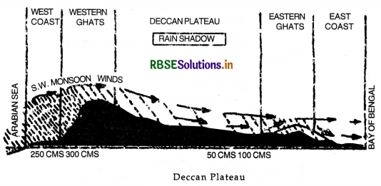
4. Which area is a rain shadow area?
(A) Deccan Plateau
(B) Assam
(C) Gujarat
(D) Kerala
Answer:
(A) Deccan Plateau
5. Which is the coldest place in India?
(A) Srinagar
(B) Shimla
(C) Dras
(D) Shillong
Answer:
(C) Dras
6. Which is the hottest place in India?
(A) Nagpur
(B) Bangalore
(C) Bormer
(D) Kanpur
Answer:
(C) Bormer
7. What is the direction of summer monsoon?
(A) South-West
(B) North-East
(C) South-East
(D) North-East
Answer:
(A) South-West
8. Along the coast of which country, El-Nino flows?
(A) Peru
(B) South Africa
(C) Australia
(D) Europe
Answer:
(A) Peru
9. Winter cyclonic rainfall helps the growth of crops.
(A) Rice
(B) Maize
(C) Wheat
(D) Cotton
Answer:
(C) Wheat
10. What is the duration of monsoon winds in India?
(A) 61 days
(B) 90 days
(C) 120 days
(D) 150 days
Answer:
(C) 120 days
Very Short Answer Type Questions
Question 1.
Which type of climate is found in India?
Answer:
Tropical monsoon climate.
Question 2.
Which parallel of latitudes passes through the middle of the country?
Answer:
Tropic of cancer.
Question 3.
Name the two climatic zones formed by Tropic of Cancer.
Answer:
Tropical and Temperate zone.
Question 4.
Name the hottest place in India.
Answer:
Barmer (50°C) in Rajasthan.
Question 5.
Name the coldest place in India.
Answer:
Dras (Kargil) - 50°C.
Question 6.
Name the rainiest place in India.
Answer:
Mawsynram near Cherrapunji-1187 cm of annual rainfall.
Question 7.
What is the cause of winter rainfall in N.W. India?
Answer:
Western disturbances (cyclones).
Question 8.
What is the cause of winter rainfall on S.E. Coast of India?
Answer:
N.E. Monsoons.
Question 9.
From which word 'Monsoon' has been derived?
Answer:
From Arabic word-Mausim.
Question 10.
What type of winds are monsoons?
Answer:
Seasonal winds.
Question 11.
What is the direction of summer monsoons?
Answer:
South-West to North-East.
Question 12.
What is the direction of winter monsoons?
Answer:
North-East to South-West.
Question 13.
Name an upper air movement which brings monsoons to India.
Answer:
Jet stream.
Question 14.
Name a state which is the first to receive the S.W. monsoons.
Answer:
Kerala.
Question 15.
Name a state which is the first to withdraw monsoon.
Answer:
Punjab.
Question 16.
Name the four rainy months in India.
Answer:
June to September.
Question 17.
Name two areas getting more than 200 cm of rainfall.
Answer:
Western coast and N.E. hilly area.
Question 18.
Which states experience Nor'westers or Kal Baisakhi?
Answer:
West Bengal and Assam.
Question 19.
Name a type of Pre-monsoon rainfall.
Answer:
Mango showers.
Question 20.
What is ‘loo’?
Answer:
A hot dusty wind blowing in summer.
Question 21.
Name an area getting rainfall in both the seasons.
Answer:
Tamil Nadu.
Question 22.
What is climate?
Answer:
An average of atmospheric conditions for a long period.
Question 23.
What do you mean by ‘break of monsoons’?
Answer:
The sudden approach of S.W. Monsoons.
Question 24.
What is October heat?
Answer:
The oppressive weather due to high temperature are high humidity in the month of October.
Question 25.
Name the coastal states struck by tropical cyclones.
Answer:
Tamil Nadu, Andhra Pradesh, West Bengal and Odisha.
Question 26.
In which part of the country ‘loo’ blows?
Answer:
Northern plain.
Question 27.
Name the two branches into which the S.W. monsoon winds are divided.
Answer:
- Bay of Bengal branch
- Arabian Sea branch.
Question 28.
What is meant by ‘Rain shadow’?
Answer:
The leeward dry slope of a mountain.
Question 29.
June is the hottest month and not the July in India. Why?
Answer:
Due to heavy rains there is a drop of 10°C in temperature in the month of July.
Question 30.
What are pre-monsoons?
Answer:
Before the advance of monsoons, some local winds give pre-monsoon rainfall.
Question 31. Name the location of Jet stream in February.
Answer:
25°N.
Question 32.
Which isohyet runs through Prayagraj?
Answer:
100 cms.
Short Answer Type Questions
Question 1.
What does the word ‘Monsoon’ imply?
Answer:
The word 'Monsoon' is said to be derived from the Arabic word Mausim’ meaning season. This word was first applied to the winds blowing over the Arabian Sea. Monsoon implies seasonal reversal of the wind pattern over the year. Monsoon winds are those seasonal or periodic winds which change their direction with the season. These winds blow from sea to land for six months during summer and from land to sea for months during winter. Thus with the change of season the pattern of winds, temperature and rainfall changes.
Question 2.
Explain what is meant by ‘jet Stream’.
Answer:
Jet Streams are high velocity winds at high altitudes. A jet stream is a narrow tubular shaped flow of wind along the troposphere. These have a velocity of 500 kms. per hour and are located at altitude of 5 to 12 kms. with an average location between 20°S to 40°N latitudes. The Himalayas divide the jet stream into two parts-Northern and Southern. Monsoons are controlled to some extent by Easterly jet stream in winter.
Question 3.
State three dominant characteristics of the Indian monsoons.
Answer:
The Indian monsoons have the following dominant characteristics:
- Change in direction of winds ; Monsoons imply the seasonal reversal of the wind pattern during winter and summer.
- Uncertain and variable rainfall leading to droughts and floods.
- Monsoons, despite regional diversities, provide the basic climatic unity of the subcontinent.
Question 4.
How many seasons can be recognised in India?
Answer:
The meteorologists divide the calendar year into four main seasons as recognised in Indian weather.
- The Cold Weather season-December to February
- The Hot Weather season-March to Mid June
- The Rainy Season-Mid June to Mid September.
- The Season of-Mid September to Retreating Monsoons November.
Question 5.
What are western disturbances? In what parts do they cause precipitation during winter in India?
Answer:
The general circulation of winds system is disturbed by some atmospheric disturbances. Western disturbances are low-pressure systems which originate in west Asia and the regions near Mediterranean Sea. These travel eastwards across Iran and Pakistan and reach India during the winter season. The westerly Jet stream steers these disturbances towards India. These are active in winter in northern India.
On an average, four or five such depressions visit India each month. These give rainfall in areas of J & K, Punjab, Himachal Pradesh, Haryana and Rajasthan. These give snowfall in N.W. Himalayas. The amount of rainfall decreases towards the east. The rainfall is of great importance to the Rabi crops especially wheat. The average rainfall varies from 20 mm. to 50 mm.
Question 6.
What do you understand by the term ‘Loo’?
Answer:
‘Loo’ is a local wind. It is a very hot and dry wind which blows during the day time in Northern India. Loo increases the dry temperatures ranging between 40°C and 50°C. The hot and dry winds are unbearable. These result in 'heat wave' causing many deaths.
Question 7.
What is meant by the phrase ‘Monsoon Burst’?
Answer:
The monsoon winds blow in south-west direction on the West coast. These are highly charged with water vapour. It advances rapidly over West coast. The rains begin rather suddenly in the first week of June. This sudden onset of rain is often termed as Monsoon Burst’. The rainfall is heavily accompanied by thunder and lightning. The rain is so sudden and heavy that it appears as if a balloon of water has been burst.
Question 8.
Give three main characteristics of summer monsoon rainfall.
Answer:
Main Characteristics:
- It is a seasonal rainfall. Most of the rain comes in summer.
- The rainfall is uncertain and variable.
- The amount of rain decreases away from the coast. In northern plain, it decreases westward up the Ganges valley, for example-Kolkata 119 cms., Patna 105 cms., PrayagrajlOO cms. and Delhi 65 cms.
- S.W. monsoons have 'breaks' or spells of dry weather. The rain does not fall continuously.
- The intensity and amount of rain is increased by jet stream and depressions.
- Tamil Nadu and Deccan plateau remain dry as these are rain shadow areas.
Question 9.
Which are the coldest parts of India and why?
Answer:
The Trans-Himalayan region consisting of Ladakh and Himachal Pradesh are the coldest part of India. The minimum temperatures of- 50°C are recorded at Dr as or Kargil (Ladakh). This is due to the fact that this place lies at a great altitude. These regions get snowfall during winter and temperature remains below freezing point.
Question 10.
Which are the hottest parts of India? What makes them so?
Answer:
The highest temperatures are found in the western parts of Rajasthan. Barmer is the hottest place where summer temperatures of 50°C are recorded. The high temperatures are due to:
- This place has an inland location, and is located away from the Indian Ocean. The continental effect raises the summer temperature.
- Hot dusty winds-Loo raises the temperature of this area.
- The temperatures remain high due to sandy soils and lack of humidity.
Question 11.
Which are the wettest and driest parts; of India? Give reasons. •
Answer:
Wettest parts. Mawsynram near Cherrapunji, with an annual rainfall of 1280 cms. is the wettest place in India. N.E. Hilly region, Western ghats and West coast are the wettest parts receiving more than 200 cms. of rainfall. The on-shore S.W. monsoons give heavy rainfall in this hilly region. Driest parts. Jaisalmer (Rajasthan) with 12 cm. rain, is the driest place in India. The driest parts are (i) Thar desert in Rajasthan (ii) Ladakh region (iii) Deccan plateau (rain shadow area). Aravallis are situated parallel to S.W. monsoon and do not help in getting any rain. Deccan plateau and Ladakh are situated in rain shadow areas.
Question 12.
State the two major factors on which Koeppen's method of classification of climate is based.
Answer:
Koeppen has divided India into different climatic divisions. This classification is based on two factors. This method is based on the monthly values of temperature and precipitation. This is a quantitative and systematic method. Capital alphabets are used to show a particular major type and small alphabets are used for sub-divisions.
Question 13.
Describe the effect of El Nino on Indian Monsoons.
Answer:
El-Nino and the Indian Monsoon El-Nino is a complex weather system that appears once every five to ten years, bringing drought, floods and other weather extremes to different parts of the world. The system involves ocean and atmospheric phenomena with the appearance of warm currents off the Coast of Peru in the Eastern Pacific and affects weather in many places including India. El-Nino is used in India for forecasting long range monsoon rainfall. In 1990-91 there was a wild El-Nino event and onset of southwest monsoon was delayed over most parts of the country ranging from five to twelve days.
Review Questions - Give Reasons
Question 1.
‘Mawsynram receives the highest amount of rainfall in the world.’ Why?
Answer:
Mawsynram is the rainiest place of the world with an average annual rainfall of 1187 cms. It is located on the Southern slopes of Khasi Hills (Meghalaya) at a height of 1500 metres above sea level. This place is enclosed by hills on three sides. The relief features give this place a funnel shaped location. The Bay of Bengal branch of monsoons is trapped in these hills. These winds try to get out of it. These are forced to rise again and again resulting in heavy rainfall. In the year 1861, an amount of 2262 cms of rainfall was recorded here.
Question 2.
‘Tamil Nadu coastal region receives most of the rain in winter.’ Why?
Answer:
Tamil Nadu lies on the Coromandel coast on the eastern coastal plain. This region receives rainfall in winter as well as summer. It receives most of rainfall in winter.
(i) In summer, Tamil Nadu remains dry as this plain lies in the rain shadow of Western Ghats.
(ii) In winter, N.E. monsoons pick up moisture as these cross Bay of Bengal. These retreating monsoons are on-shore winds in Tamil Nadu coastal plain. The Eastern Ghat forces these winds to give moderate rainfall in this area.
Question 3.
The North-West plains of India experience winter rainfall.’ Why?
Answer:
The north-west plains of India consisting of Punjab, Haryana, Rajasthan and Western Uttar Pradesh receive some winter rainfall ranging between 20 and 50 mm. This rainfall is caused due to the invasion of western disturbances (cyclones). These cyclones originate in West Asia and in Mediterranean Sea. The westerly Jet steam steers these cyclones into India during winter. The north-west plains get rainfall and the hilly areas get snowfall. The amount of rainfall decreases eastward.
Question 4.
The rainfall in a year at Jaisalmer rarely exceeds 12 centimetres.’Why?
Answer:
Jaisalmer lies in the extreme west of Rajasthan (Thar Desert). It has an annual rainfall less than 12 cms.
(i) Jaisalmer lies to the west of Aravallis in Rajasthan. This area comes under the influence of Arabian Branch of monsoons. These winds move forward, blowing parallel to the S.W. direction of Aravallis. These mountains due to their direction, fail to check these winds. Therefore Jaisalmer does not get any rainfall.
(ii) The Bay of Bengal branch monsoons become dry till these reach this area.
(iii) This area lies away from the northern mountains and thus does not get any rainfall.
(iv) It lies in the sub-tropical high pressure belt where due to descending winds, there is no rainfall.
Question 5.
Why is the co-efficient of variation of annual rainfall low on the west coast of India and high in Kutchh and Gujarat?
Answer:
The main features of the monsoon rainfall in India is its variability from year to year. The same place gets different amounts of rainfall every year. When the actual rainfall of a place in a year deviates from its mean annual rainfall, it is known as variability of rainfall. The variability of annual rainfall is calculated with the help of the following formula:
Co-efficient of variation
\(=\mathrm{Cv}=\frac{\text { Standard deviation }}{\text { Mean }} \times 100\)
The co-efficient of variation is as low as 15 per cent on the west coast of India.
In these areas, the monsoons have a similar effect every year due to nearness to sea. The co-efficient of
variation is as high as 40 per cent in the Kutchh and Gujarat. In these areas, monsoons are sometimes weak and inconsistent. These are semi-desert areas. Some parts experience a co-efficient of variation between 50% to 80%. There is no high mountain in this area to check the monsoons.
Question 6.
Why is the Western part of Rajasthan arid?
Or
The western part of Rajasthan remains almost dry during south-west monsoon season. Give three important reasons in support of this statement.
Answer:
The western part of Rajasthan is a desert. It gets an annual rainfall less than 20 cms. This is due to the following reasons:
(i) Rajasthan is under the influence of S.W. summer monsoons. The Aravallis system lies parallel to the direction of S.W. monsoons coming from Arabian Sea. So this mountain system is unable to check these winds. So western Rajasthan is practically dry. The southern parts get some rainfall.
(ii) This area lies at a great distance from the Bay of Bengal. The Bay of Bengal monsoons become dry and lose their moisture when they reach Rajasthan.
(iii) This area is away from the Himalayan region. So it does not come under the influence of monsoons giving rain in Sub-Himalayan region.
Question 7.
Explain the impact of Global Warming.
Answer:
The climate of the world has changed in the past and is changing at present. It is said that due to global warming the polar ice caps and mountain glaciers would melt and the amount of water in ocean would increase. Carbon dioxide is the major cause of global warming. It is due to burning of fossil fuels. There are other green house gases also like methane, chlorofluorocarbons, ozone, nitric oxide. These gases are more effective at enhancing the greenhouse effect. These gases are contributing to global warming. The mean annual surface temperature of the earth in the past 150 years has increased.
It is projected that by the year 2100, global temperature will warm about 2°C. This rise in temperature will accompany many other changes: one of these is a rise in sea level, as glacier and sea ice melt in response to warming. According to the current prediction on an average, the sea level will rise 48 cm by the end of twenty first century. This would increase the incidence of annual flooding.
Climatic change would promote insect born diseases like malaria, and lead to shift in climatic boundaries, making some regions wetter and others drier. Agricultural pattern would shift and human population as well as ecosystem would experience change. If the sea level rises 50 cm above the present sea level many areas will be submerged
Essay Type Questions
Question 1.
What are Monsoons? How are these caused? Describe the winter and summer monsoons.
Answer:
Monsoons.
The word monsoon is derived from the Arabic word ‘mausim’ which means season. These monsoon winds are seasonal winds. The term was first used for the monsoon winds, blowing over the Arabian Sea. In this wind system there is a reversal of wind direction according to seasons. In summer, monsoons blow from sea to land and in winter monsoons blow from land to sea. Origin. Monsoons are land and sea breezes on large scale. These winds have a thermal origin. These are caused from the differential heating and cooling of land and water.
The chain of events is from temperature through pressure and winds to rainful. In summer, the land gets more heated than sea resulting in a low pressure on the land masses and a high pressure over seas. The winds blow from sea to land. In winter the conditions are reversed and winds blow from land to sea. Land wave breeze and sea-breeze follow a daily rhythm over a small coastal areas, but the monsoons follow a seasonal rhythm over a large area. Necessary conditions. The monsoons are developed under the following conditions
- The presence of the large land mass (continent).
- The presence of a large ocean.
- Long coast line.
- Seasonal extremes of temperature of land and water. Areas. Monsoons mostly blow in tropical areas.
The Himalayas separate these areas into two parts:
- East Asia monsoons blowing over China, Japan and Indo-China.
- Indian Monsoons of India, Pakistan, Bangladesh and Myanmar.
Summer Monsoons. The sun is vertical at the Tropic of Cancer. Rapid heating in the hot summer over Asia, gives rise to the low pressure in the Central Asia and North West India. There is high pressure over the oceAnswer: So sea to land winds blow. These are known as S. W. Summer monsoons in India. These onshore winds give heavy and sudden rainfall, which is often termed as ‘the burst of monsoon’. The heavy rainfall is due to the presence of high mountains, convectional rising of winds and cyclonic activities.
The rainfall is highly variable and uncertain. It is rightly said that, “Indian budget is a gamble on monsoons.” New Concept. According to Flohn, “The tropical monsoon is simply a modification of the general planetry wind system. The low pressure system of Northern India is a northward extension of the equatorial low (N.I.T.C.). The S.E. Trade winds after crossing the equator become south-west during summer monsoons.
During the winter N.I.T.C. (Northern Inter Tropical Convergence) moves southward and the normal trade winds are re-established as the N.E. winter monsoons. Winter Monsoons. In winter the land mass of Asia becomes cold while the adjoining oceans are comparatively warm. High pressure develops over Central Asia and North-West India. It results in a reversal of wind directions so that land to sea winds blow. These are mostly dry and are known as North East monsoon in India. After crossing Bay of Bengal, these winds give rainfall over south-east coast of India.
Question 2.
Describe the climatic conditions which prevail over India during different seasons.
Answer:
SEASONS.
The Indian sub-continent has a tropical monsoon climate. India has a broad unity of monsoon type of the climate having a same rhythm of seasons. The advance and retreat of monsoons divide the weather into different seasons.
Seasons:
(A) Seasons of N.E. Monsoons:
- The Cold Seasons. January to February
- The Hot Seasons. March to May
(B) Seasons of S.W. Monsoons:
- The Rainy Season. June to September.
- The Season of Retreating Monsoon. October to December.
I. The Cold Season. The cold season lasts from January to February.
(a) Temperature. The sun is over head at Tropic of Capricorn. The Indian subcontinent has winter season. January is the coldest month. The southern parts have warm conditions (20°C) while low temperatures (10°C) are found in N.W. India and the Trans-Himalayan region of Ladakh which are the coldest parts of India. The minimum temp, of - 50°C are recorded at Dras or Kargil (Ladakh).
(b) Pressure and Winds. High pressure is developed over N.W. part while a low pressure exists over Indian Ocean with the result winds blow from land to sea.
(c) Rainfall. The N.E. Monsoons are off-shore winds are dry. But these winds pick up some moisture while crossing Bay of Bengal and give rain to S.E. coast of India. Some cyclones from Mediterranean Sea also bring a small amount of rain (10 to 20 cm.) to Northern plains. Leh (Ladakh) gets moderate rainfall in winter and has precipitation throughout the year in one form or the other. Night Frost is common in the N.W. part.
II. The Hot Season. The hot season lasts from March to May.
(a) Temperature. As the sun’s rays fall vertical over Tropic of Cancer, the temperature begins to rise. The average temperature is above 30° C, the maximum temperature rises to 50° C in Barmer (Rajasthan). The daily range of temperature rises in inland areas.
(b) Pressure and Winds. Intense heat results in the development of low pressure (monsoon low pressure trough) over N.W. India and Pakistan. A high pressure
exists over Indian Ocean. S.W. Monsoons begin to blow from sea to land. ‘Norwesters’ and ‘Loo’ blow over Northern plains.
(c) Rainfall. Some areas receive convectional rainfall. The west coast also starts receiving rainfall. Most of the country is dry in the pre-Monsoon period.
III. The Rainy Season. The rainy season lasts from June to September.
(a) Temperature. The sun shines vertical over Tropic of Cancer. The temperature is more than 30° C. With the on-set of monsoon, there is a drop in temperature (5° to 10°) with the result, July is not the hottest month.
(b) Pressure and Winds. S.W. Monsoons blow from sea to land with a ‘burst’ on the West coast. It blows in two currents (i) Arabian sea current
(ii) Bay of Bengal current.
(c) Rainfall. S.W. Monsoons are rain giver. The Arabian sea branch gives heavy rainfall on the west coast, but Deccan plateau lies in the rain shadow of western ghats. The Bay of Bengal branch gives heavy rainfall in Eastern Himalayas. Rajasthan is practically a desert.
IV. The Season of Retreating Monsoon. S.W. Monsoons begin to withdraw from the subcontinent during the first week of October. This is a transition
period from hot rainy season to dry winter. The direction of monsoon is reversed. These dry winds are called retreating monsoons. The sun begins to move towards equator. There is a decrease in temperature. Hot and sticky weather is found. High day temperatures causes unpleasant weather called ‘October heat’. Some tropical cyclones are developed which give heavy rainfall in coastal areas. Cool weather begins in N.W. India, but the Southern parts have an equable climate.
The Monsoonal Unity of India.
There is a great diversity of climatic conditions of India due to vast size and difference in relief. But the monsoonal rhythm of seasons is great unifying force in India. Monsoons control the climatic conditions all over India. The distribution of rainfall is seasonal. Agriculture depends upon monsoonal rainfall resulting in a subsistence agriculture. Agriculture in India is a gamble on monsoons. The folk songs like Kajari of Bhojpur and Malhar of Braj are associated with monsoonal rains. Thus Monsoons provide a natural base for a uniformity throughout the country. The Indian landscape, its animals and plants, agricultural calendar (Kharif and Rabi seasons) life of the people and their festivals revolve around monsoons.
Question 3.
Discuss the chief features of the summer monsoon rainfall and its significance in the agricultural economy of the country.
Answer:
The average annual rainfall in India is about 110 cms. It is estimated that more than 85% or this rainfall is received in summer. The main characteristics of summer rainfall are as follows:
- Monsoonal rainfall. Most of rainfall is received from South West summer monsoons during the period mid-June to mid-September. It is seasonal rainfall.
- Uncertain rainfall. Summer rainfall is quite uncertain. Sometimes monsoons start early resulting in floods: often the onset of monsoons is delayed resulting in drought. The early or late retreat of monsoons also results in serious droughts.
- Unequal distribution. The rainfall is unevenly distributed over the country. About 10% of the country gets more than 200 cms. of rain while 25% of the country gets less than 75 cms. of rain.
- Heavy rainfall. Indian rainfall is heavy and downpouring type. It is often said, “It pours, it never rains in India.”
- Relief rainfall. The amount of rainfall is determined by the presence of mountains. High mountains force monsoons to rise and give rain.
- No continuity of rainfall. Summer rain is characterised by breaks or dry spells.
- Variable rainfall. Most of the areas have variable rainfall, as much as 30 cms. plus or minus. Due to variability in areas of low rain, famines occur.
Significance of Monsoons in Agriculture.
- India is essentially an agricultural country. Indian agriculture and economy is dependent on South West summer monsoons. Indian agriculture is the backbone or pivot of Indian economy. It has rightly been said, “Indian budget a gamble on monsoons.”
- Indian rainfall is seasonal. The summer crops or Kharif crops depend on monsoons.
- The failure of summer monsoons results in famines and food shortage. ‘If monsoons fail, there is a lock-out in agriculture industry.’
- Most of foodgrains like Rice, Jowar, Maize etc. grown as Kharif crops depend on rainfall. Good rains have resulted in bumper crops.
- The amount of rainfall determines the cropping pattern. Rice, Sugarcane, Tea, Jute etc. are grown in areas with over 200 cms. of rain. Dry areas have crops like millets, pulses, oil, seeds, etc.
- The uniform distribution of rain results in multiple cropping.
- Uncertain and variable rainfall requires the use of irrigation. The winter crops like wheat depend on irrigation.
- Thus the agricultural rhythm of crops depend on rainfall. It has often been said, “The rain becomes the blood of life and agriculture is closely wedded to the monsoon.”
Question 4.
Discuss in brief the mechanism of Indian weather with special reference to jet streams.
Answer:
Mechanism of Indian Weather. The
mechanism of Indian weather depends upon the following factors:
- Surface distribution of pressure and winds.
- Upper air circulation.
- The flow of different air masses.
- Western disturbances.
- Jet stream.
The Indian weather is the outcome of inter play of the above factors.
(1) The Distribution of Winds and Pressure:
The Indian weather conditions during winter season are influenced by high pressure centres in central and western Asia. The dry winds from this high pressure blow out towards Indian sub-continent. Dry winds are felt in N.W. parts of India. The whole of North West and Northern India upto middle Ganges valley come under the influence of N.
Western winds. During the summer, the sun shifts towards North. The pressure and wind circulation is completely changed. A low pressure area is established in North West India, the equatorial trough also moves northward. The maritime trade winds from the southern hemisphere, after crossing the equator moves, towards low pressure area. These are called south western monsoons. These are rain giving winds in summer.
(2) Upper air circulation. Pressure and winds bring changes at lower level on the surface. But upper air circulation and airmasses are also important. Jet stream, in upper air, is helpful in bringing western disturbances over India. So jet stream affects Indian weather.
(3) Western disturbances. Low pressure areas form in India during winter season. These cyclones originate over mediterranean sea. These enter India after crossing Iran, Pakistan and give rainfall in India during months of January-February.
(4) Jet Stream. Jet streams are high velocity winds at high altitudes (at upper troposphere). Jet stream is a current of westerly winds blowing over Central Asia and the Himalayas. Indian weather and Monsoons are controlled by jet stream in many ways.
(i) The location of high pressure in central Asia results in North West continental air masses blowing over North India during winter.
(ii) Jet stream current brings these winds along with western disturbances over India. These cyclones or disturbances originate in Mediterranean Sea and give a light rain in winter in Northern India.
(iii) Himalayas bifurcate the westerly winds into two branches-Northern and Southern branches. The southern branch flows at a latitude of 25°N.
(iv) In summer, the equatorial low pressure or Inter- Tropical Convergence Zone (I.T.C.Z.) replaces the jet stream. This low pressure attracts S.W. monsoons, S.W. monsoons are continuation of S.E. trade winds.
(v) The easterly jet stream blows over Northern India. It steers the tropical depression over India. These cyclones add to monsoonal rainfall. This explains the dry spells due to fluctuating pattern of tropical depression.
Question 5.
Divide India into various climatic types according to the scheme devised by Koeppen.
Answer:
India has primarily a tropical monsoon type of climate. Due to its vast size and extent many regional variations of climate are found. On the basis of these, many regional patterns or sub-types of climate can be recognised. India has been divided into many climatic divisions. Each division has a broad uniformity of temperature and precipitation.
Koeppen’s scheme of climatic classification. A German meteorologist, Wladimir Koeppen has divided
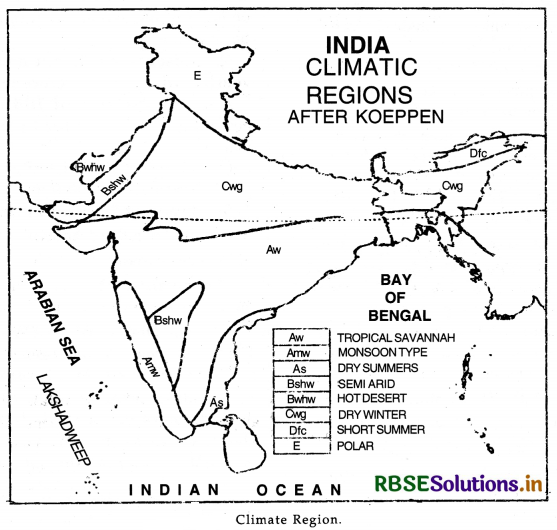
the world into different climatic divisions. His method is based on mean monthly values of temperature and precipitation. Koeppen has identified five major climatic types. Capital letters have been used as symbols to show these such as A, B, C, D and E. The five types have been further subdivided into sub-types. Small alphabets are used to show these sub-types. Based on Koeppen's method, India can be divided into the following climatic regions:
A= Tropical climate
B = Dry climate
C = Warm climate
D = Cold climate
E = Snow or Polar climate
- Monsoon type with short dry season: (Amw). This type of climate prevails over western coast of India, South of Goa. The summers are wet and there is a short dry winter season.
- Monsoon type with dry summers: (As). This type of climate prevails over Coromandel coast (Tamil Nadu). It has dry summers and wet winters.
- Tropical Savannah type: (Aw). This type of climate is found in Peninsular plateau. It has dry winters.
- Semi-arid steppe climate (Bshw). This type of climate is found in desert areas of Rajasthan and Haryana.
- Hot desert type (Bwhw). This type of climate is found in the Extreme Western Rajasthan (Thar Desert).
- Monsoons type with dry winters (Cwg.). This type of climate is found in Northern plains of India. Most of rain falls in summer.
- Cold humid winter type with shorter summer (Dfc). This type of climate prevails over North East part of India. It has cold and wet winters with shorter summers.
- Polar climatic (E). This type of climate is found in Ladakh and adjoining mountain ranges.
Question 6.
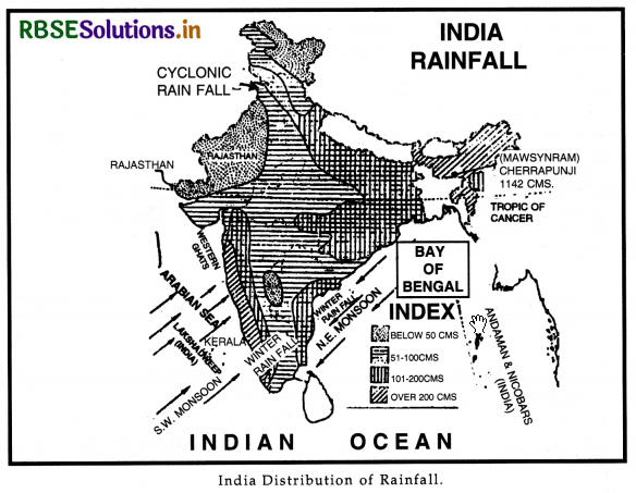
Give an account of distribution of annual rainfall in India. How is it related to the relief of the country?
Answer:
The average annual rainfall of India is 110 cms. Regional variations in the distribution are found due to differences in relief of the country. Rainfall is unevenly distributed throughout the country. India can be divided into the following rainfall regions:
- Areas of Heavy Rainfall. These areas get more than 200 cms. of annual rainfall. These include Western Coast and Western Ghats, Sub-Himalayas and the N.E. parts of India.
- Areas of Moderate Rainfall. These areas get annual rainfall of 100-200 cms. These include West Bengal, Odisha, Eastern parts of Uttar Pradesh and Madhya Pradesh, coastal plains of Tamil Nadu.
- Areas of Low Rainfall. These areas experience an annual rainfall of 50-100 cms. These include western part of Uttar Pradesh Haryana, Punjab, Gujarat, Peninsular plateau and Eastern Rajasthan.
- Areas of Scanty Rainfall. These areas get less than 50 cms. of annual rainfall. These include
Ladakh, S.W. Punjab, Southern Haryana, Western Rajasthan, Kutchh and Thar Desert.
Effect to Relief on Rainfall.
Orographic features play an important part in the distribution of rainfall in India. The amount of rainfall in an area is determined by the situation of the mountains. On the whole, it may be called relief rainfall in India. In mountain areas of Khasi-Jaintia hills the annual rainfall exceeds 1000 cms. In Ganga Valley, the amount of rainfall goes on decreasing. The on-shore winds give heavy rainfall on windward slopes but rain shadow areas remain dry. Garo-Khasi hills get more than 1000 cms.
of annual rainfall, but the amount drops to 200 cms. over Shillong plateau and Brahmputra Valley lying in the rain shadow. Malabar coast and Western Ghats get more than 300 cms. of rainfall, but Deccan plateau lies in the rain shadow of Western Ghats and remains dry (60 cms, rainfall). In Rajasthan, the Aravalli system lies parallel to the direction of the South West monsoons and is unable to force these winds to rise. So Rajasthan remains practically dry.
Source Based Questions
1. Read the following paragraph and answer the questions given below:
The word Monsoon is said to be derived from the Arabic word Mausim meaning season. This word was first applied to the winds blowing over the Arabian sea. Monsoon implies seasonal reversal of the wind pattern over the year. Monsoon winds are those seasonal or periodic winds which change their direction with the seasons. These winds blow from sea to land for six months during summer and from land to sea for six months during winter. Thus with the change of season, the pattern of winds, temperature and rainfall changes. The Indian Monsoon have several characteristics such as uncertain and variable rainfall leading to droughts of floods.
(i) From where was the word Monsoon derived?
(a) Latin
(b) Greek
(c) Arabic
(d) Sanskrit
Answer:
(c) Arabic
(ii) The word Monsoon was first applied to the winds blowing over
(a) Bay of Bengal
(b) Arabian Sea
(c) Indian Ocean
(d) None of these
Answer:
(b) Arabian Sea
(iii) How monsoon winds change their direction?
(a) With winds
(b) With seasons
(c) With nature
(d) With humidity
Answer:
(b) With seasons
(iv) During summers, these winds blow from-
(a) land to sea
(b) sea to land
(c) sea to sea
(d) land to land
Answer:
(b) sea to land
2. Read the following paragraph and answer the questions given below:
Loo is a local wind. It is very hot and dry wind which blows during the day time in Northern India. Loo increases the dry temperatures ranging between 40°C and 50°C. The hot and dry winds are unbearable. These result in heat wave causing many deaths. The monsoon winds blow in south-west direction on the west-coast. These are highly charged with water vapour. It advances rapidly over west coast. The rains begin rather suddenly in the first week of June. This sudden onset of rain is often termed as Monsoon Burst. The rainfall is heavily accompanied by thunder and lightning. The rain is so sudden and heavy that it appears as if a balloon of water has been busted.
(i) Which of the following is a hot and dry wind?
(a) Loo
(b) Kal Baisakhi
(c) Trade
(d) Monsoon
Answer:
(a) Loo
(ii) What is the condition of temperature during Loo?
(a) Temperature increases
(b) Temperature decreases
(c) Temperature does not change
(d) All of these.
Answer:
(a) Temperature increases
(iii) In which direction do the monsoon winds blow on the west coast?
(a) North west
(b) North east
(c) South west
(d) South east
Answer:
(c) South west
(iv) The sudden onset of rain is called-
(a) Monsoon Blast
(b) Heavy rainfall
(c) Monsoon Dhamaka
(d) Monsoon Burst
Answer:
(d) Monsoon Burst
HOTS QUESTIONS
Question 1.
“In India most of the rainfall is of relief; type.” Discuss. 1
Answer:
Orographic features play an important part in the distribution of rainfall in India. The amount of rainfall in an area is determined by the location of the mountains. On the whole it may be called relief rainfall in India,
(i) In the mountainous areas of Khasi and Jaintia hills annual rainfall exceeds 1000 cm.
(ii) In the Ganga valley, the amount of rainfall goes on decreasing from east to west,
(iii) The onshore winds cause heavy rainfall on the windward slopes but the rain shadow areas remain dry. Garo and Khasi hills get more than 1000 cm of annual rainfall, but the amount drops to 200 cm over Shillong Plateau and Brahmaputra Valley lying in the rain shadow region. The Malabar Coast and the Western Ghats get mroe than 300 cm of rainfall, but the Deccan Plateau lies in the rain shadow of the Western Ghats and remains dry (60 cm rainfall). In Rajasthan, the Aravalli system lies parallel to the direction of the S.W. monsoons and is unable to force these winds shed their moisture. So Rajasthan remains practically dry.
Question 2.
Why are Monsoons considered as a unifying bond in India?
Answer:
There is a great diversity in climatic conditions of India due to differences in the relief features. But due to monsoon winds India has primarily a monsoon type of climate throughout the country. The whole country is influenced by the same order of seasons. The Monsoonal rhythm of seasons is a great unifying force in India as:
(i) Monsoons control the atmospheric conditions of the country. Throughout the country, the summers are wet and the winters are dry due to the onshore winds. The distribution of rainfall is seasonal.
SELF EVALUATION TEST
- Name the rainiest place of India.
- Name any four rainy months.
- What is meant by ‘Rain shadow’?
- What ius Loo?
- What is meant by Jet Stream?
- What is monsoon burst?
- Which are coldest parts of India?
- Describe the effect of EL-Nino.
- What are Western disturbances?
- Describe the main features of summer rain fall.
