RBSE Solutions for Class 9 Social Science Geography Chapter 2 Physical Features of India
Rajasthan Board RBSE Solutions for Class 9 Social Science Geography Chapter 2 Physical Features of India Textbook Exercise Questions and Answers.
Rajasthan Board RBSE Solutions for Class 9 Social Science in Hindi Medium & English Medium are part of RBSE Solutions for Class 9. Students can also read RBSE Class 9 Social Science Important Questions for exam preparation. Students can also go through RBSE Class 9 Social Science Notes to understand and remember the concepts easily. The india size and location important questions are curated with the aim of boosting confidence among students.
RBSE Class 9 Social Science Solutions Geography Chapter 2 Physical Features of India
RBSE Class 9 Social Science Physical Features of India InText Questions and Answers
Question 1.
The names of the glaciers and passes that lie in the Great Himalayas.
Answer:
Glaciers in the Great Himalayas-Gangotri, Chaturangi, Bhagirathi, Kharak, Satopanth, Kamet, Milam and Pindari.
Passes in the Great Himalayas-Shipki La, Nathu La, Bomdi La, Khardung La, Chang-La.

Question 2.
The states where India’s top highest peaks are located?
Answer:
Sikkim, Jammu and Kashmir , Uttarakhand, Arunachal Pradesh
Question 3.
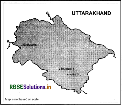
Location of Mussoorie, Nainital and Ranikhet from your atlas and also name the state where they are located.
Answer:
These places are located in the state of Uttarakhand
RBSE Class 9 Social Science Physical Features of India Textbook Questions and Answers
Question 1.
Choose the right answer from the four alternatives given below:
(i) A landmass bounded by sea on three sides is referred to as
(a) Coast
(b) Island
(c) Peninsula
(d) None of these
Answer:
(c) Peninsula
(ii) Mountain ranges in the eastern part of India forming its boundary with Myanmar are collectively called
(a) Himachal
(b) Uttarakhand
(c)Purvachal
(d) None of these
Answer:
(c) Purvachal
(iii) The Western coastal strip, South of Goa is referred to as
(a) Coromandel
(b) Konkan
(c) Kannad
(d) Northern Circar
Answer:
(c) Kannad
(iv) The highest peak in the Eastern Ghats is
(a)AnaiMudi
(b) Kanchenjunga
(c)Mahendragiri
(d)Khasi
Answer:
(c) Mahendragiri
Question 2.
Answer the following questions briefly :
(i) What is the bhabar?
Answer:
Bhabar is 8 to 16 km wide belt of land in the northern plain lying parallel to the slopes of Shiwaliks. The rivers descending from the Himalayan mountains deposit pebbles here.
(ii) Name the three major divisions of the Himalayas from north to south.
Answer:
The three major divisions of the Himalayas from North to South are as follows :
(a) The Great or Inner Himalayas or the Himadri
(b) The Lesser Himalayas or the Himachal
(c) The Outer Himalayas or the Shiwaliks
(iii) Which plateaus lies between the Aravali and the Vindhyan ranges?
Answer: The Malwa plateau lies between the Aravali and the Vindhyan ranges.
(iv) Name the island group of India having coral origin.
Answer:
Lakshadweep is the island group of India having coral origin.
Question 3.
Distinguish between:
(i) Bhangar and Khadar.
Answer:
|
Bhangar |
Khadar |
|
(i) The part of the northern plain formed of older alluvium is known as bhangar. |
(i) The part of the northern plain formed of younger alluvium is known as khadar. |
|
(ii) Bhangar is the largest part of the . northern plain. |
(ii) Khadar is comparatively a smaller part of the northern plain. |
|
(iii)They lie above the flood plains of the rivers. |
(iii)They lie in the flood plains of the rivers. |
|
(iv)The soil in this region contains calcareous deposits locally known as kankar. |
(iv)The soil in this region is fine grained. |
|
(v) They are less fertile as they are not renewed every year. |
(v) They are renewed almost every year and hence are very fertile. |
(ii) Western Ghats and Eastern Ghats.
Answer:
|
Western Ghats |
Eastern Ghats |
|
(i) Western Ghats mark the western edge of the Deccan Plateau. |
(i) Eastern Ghats mark the eastern edge of the Deccan Plateau. |
|
(ii) They lie parallel to the western coast along the Arabian Sea. |
(ii) They lie parallel to the eastern coast (between the Mahanadi Valley to the Nilgiris) along the Bay of Bengal. |
|
(iii)They are continuous and can be crossed through passes only. |
(iii)They are discontinuous and dissected by rivers draining into the Bay of Bengal. |
|
(iv)They are higher than the Eastern Ghats with average elevation between 900 and 1600 metres. |
(iv) They are comparatively lower than the Western Ghats with average elevation of 600 metres. |
|
(v) The Anai Mudi is the highest peak of Western Ghats. |
(v) Mahendragiri is the highest peak of Eastern Ghats. |
Question 4.
Which are the major physiographic divisions of India? Contrast the relief of the Himalayan region with that of the peninsular plateau.
Answer:
The major physiographic divisions of India are
(i) The Himalayan Mountains
(ii) The Northern Plains
(iii) The Peninsular Plateau
(iv) The Indian Desert
(v) The Coastal Plains
(vi) The Islands
Differences between the relief of the Himalayan region and the Peninsular plateau are as follows :
|
Himalayan Region |
Peninsular Region |
|
(I) The Himalayas are one of the most recently formed landforms. |
(i) The peninsular plateau is one of the most ancient landmass on earth. |
|
(ii)The Himalayas are the loftiest mountains of the world with sharp peaks and a number of deep valleys. |
(ii) The Peninsular plateau has rounded hills with gentle slopes and broad and shallow valleys. |
|
(iii)The Himalayas consist of a series of parallel mountain ranges namely, ' -the great Himalayas, the lesser Himalayas and the Outer Himalayas. |
(iii)The Peninsular plateau is a series of plateaus such as the Malwa plateau, Chotanagpur plateau, etc. |
|
(iv)The Himalayas are composed of the sedimentary rocks. |
(iv)The Peninsular plateau is composed of igneous and metamorphic rocks. |
|
(v) The Himalayas are a source of fresh water and forest wealth. |
(v) Peninsular plateau is rich in minerals. |
Question 5.
Give an account of the Northern Plain of India.
Answer:
(i) The Northern Plains have been formed by the interplay of the three river systems, namely - the Indus, the Ganga and the Brahmputra along with their tributories.
(ii) This plain is formed of alluvial soil. The deposition of alluvium in a vast basin lying at the foothills of the Himalaya over millions of years, formed this fertile plain.
(iii) It spreads over an area of 7 lakh sq.km. The plain being about 2400 km long and 240 to 320 km broad, is a densely populated physiographic division.
(iv) With a rich soil cover combined with adequate water supply and favourable climate it is agriculturally a productive part of India.
(v) The northern plain is broadly divided into three sections. The western part of the Northern plain is referred to as the Punjab Plains. Formed by the Indus and its tributories, the larger part of this plain lies in Pakistan.
(vi) The Indus and its tributories - the Jhelum, the Chenab, the Ravi, the Beas and the Satluj originates in the Himalaya. This section of the plain is dominated by the doabs.
Question 6.
Write short notes on the following :
(i) The Indian Desert
(ii) The Central Highlands
(iii) The Island Groups of India
Answer:
(i) The Indian Desert :
The Indian desert, also known as the Thar desert, lies towards the west of the Aravali Hills. It is an undulating sandy plain covered with sand dunes. Though barchans cover larger areas of this region, the longitudinal dunes are more prominent near the Indo-Pakistan border. This region receives very low rainfall, which is below 150 mm per year. It has arid climate and scanty vegetation. Many streams appear during the rainy season. However, they disappear into the sand as they do not have enough water to reach the sea. Luni is the only large river in this region.
(ii) The Central Highlands:
The part of the Peninsular plateau lying to the north of the Narmada river, covering a major area of the Malwa plateau, is known as the Central Highlands. The Vindhyan range is bounded by the Satpura range on the south and the Aravalis on the northwest. The further westward extension gradually merges with the sandy and rocky desert of Rajasthan.
The flow of the rivers draining this region, namely the Chambal, the Sind, the Betwa and the Ken is from southwest to northeast, thus indicating the slope. The Central Highlands are wider in the west but narrower in the east. The eastward extensions of this plateau are locally known as the Bundelkhand and Baghelkhand. The Chotanagpur plateau maks the further eastward extension, drained by the Damodar river.
(iii) The island groups of India: India has two groups of islands, the Lakshadweep and the Andaman and Nicobar.
(a) Lakshadweep:
These lie dose to the Malabar coast of Kerala. These are composed of small coral islands. Earlier, they were known as Laccadive, Minicoy and Amindive. In 1973, these were named as Lakshadweep. They cover a small area of 32 square km. Kavaratti island is the administrative headquarters of Lakshadweep. This island group has a great diversity of flora and fauna. The Pitti island, which is uninhabited, has a bird sanctuary.
(b) Andaman and Nicobar:
This is an elongated chain of islands located in the Bay of Bengal extending from north to south. In comparison to Lakshadweep these are bigger in size, more in number and are more scattered. Sanjiv Refresher Social Science class IX This group of islands is divided into two broad categories - the Andaman in the north and Nicobc r ' i the south.
These islands are believed to be an elevated portion of the submarine mountains. Due to their location, these islands are of great strategic importance for the country. They have great biodiversity. Lying close to the equator, these islands experience equatorial climate and have thick forest cover. They have India’s only active volcano on Barren island.
Map Skills
Question1.
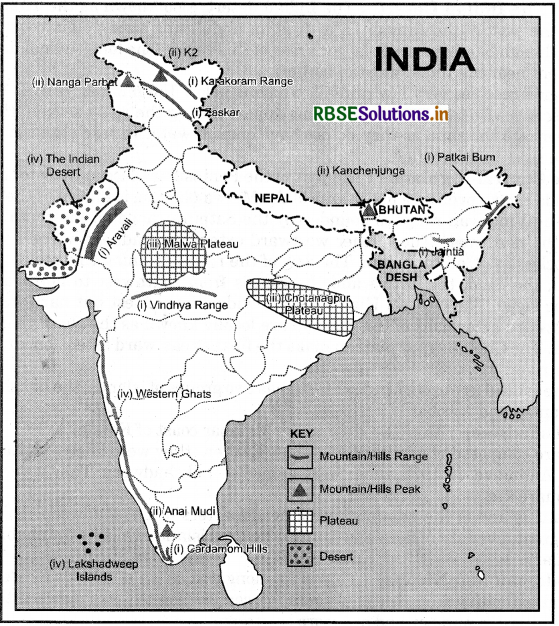
On an outline map of India show the following :
(i) Mountain and hill ranges - the Karakoram, the Zaskar, the Patkai Bum, the Jaintia, the Vindhya range, the Aravali and the Cardamom hills
(ii) Peaks - K2, Kanchenjunga, the Nanga Parbat and the Anai Mudi (Hi) Plateaus - Chota Nagpur and Malwa
(iv) The Indian-Desert, Western Ghats and Lakshadweep Islands
Answer:
Project/Activity:
Locate the peaks, passes, ranges, plateaus, hills and dunes hidden in the puzzle. Try to find where these features are located. You may start your search horizontally, vertically or diagonally.
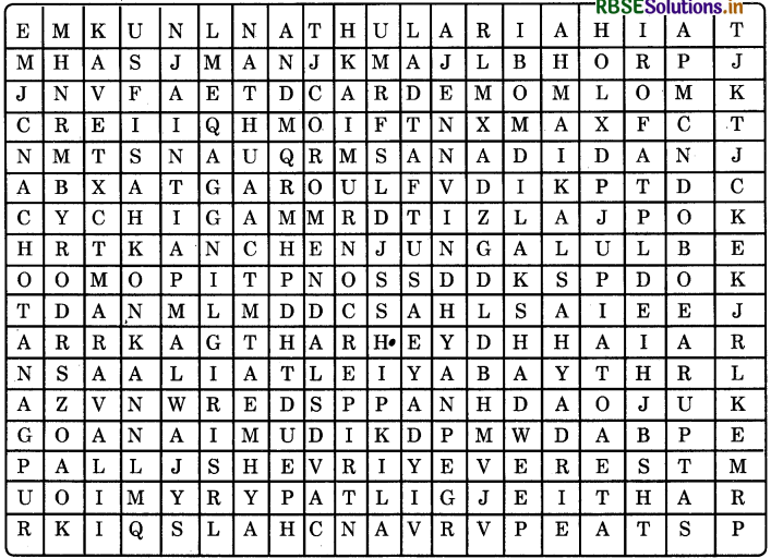
Features located horizontally are :
- Nathula (pass)
- Cardamom (hills)
- Garo (hills)
- Kanchenjunga (peak)
- Anai Mudi (peak)
- Everest (peak)
- Patli (dun)
Features located vertically are:
- Chotanagpur (plateau)
- Aravali (hills)
- Konkan (coast)
- Jaintia (hills)
- Malwa (plateau)
- Nilgiri (hills)
- Shipki La (pass)
- Vindhya (hills)
- Bomdila (pass)
- Sahyadri (hills)

- RBSE Class 9 Social Science Important Questions Civics Chapter 1 लोकतंत्र क्या? लोकतंत्र क्यों?
- RBSE Solutions for Class 9 Social Science Geography Chapter 5 Natural Vegetation and Wildlife
- RBSE Solutions for Class 9 Social Science Geography Chapter 6 Population
- RBSE Solutions for Class 9 Social Science in Hindi Medium & English Medium
- RBSE Class 9 Social Science Important Questions in Hindi & English Medium
- RBSE Class 9 Social Science Notes in Hindi & English Medium Pdf Download
- RBSE Class 7 Social Science Important Questions History Chapter 9 क्षेत्रीय संस्कृतियों का निर्माण
- RBSE Class 9 Social Science Important Questions Civics Chapter 1 What is Democracy? Why Democracy?
- RBSE Class 9 Social Science Notes Civics Chapter 4 संस्थाओं का कामकाज
- RBSE Class 9 Social Science Important Questions Economics Chapter 4 भारत में खाद्य सुरक्षा
- RBSE Solutions for Class 9 Social Science Civics Chapter 5 लोकतांत्रिक अधिकार