RBSE Solutions for Class 9 Social Science Geography Chapter 1 India-Size and Location
Rajasthan Board RBSE Solutions for Class 9 Social Science Geography Chapter 1 India-Size and Location Textbook Exercise Questions and Answers.
Rajasthan Board RBSE Solutions for Class 9 Social Science in Hindi Medium & English Medium are part of RBSE Solutions for Class 9. Students can also read RBSE Class 9 Social Science Important Questions for exam preparation. Students can also go through RBSE Class 9 Social Science Notes to understand and remember the concepts easily. The india size and location important questions are curated with the aim of boosting confidence among students.
RBSE Class 9 Social Science Solutions Geography Chapter 1 India-Size and Location
RBSE Class 9 Social Science India-Size and Location InText Questions and Answers
Page No. 2
Question 1.
Why 82°30’E has been selected as the standard meridian of India?
Answer:
82° 30’ E has been selected as the standard meridian of India to avoid confusion associated with time and to creat harmony in time through the country. The longitudinal extent of India is 30°. According to international convention the longitude that a country selects, should be divided by 7.5° and the nearest multiple of 7.5° is 82.5°. So, 82.5 E or 82° 30’ east has been selected as 1ST.

Question. 2.
Why is the difference between the durations of day and night hardly felt in Kanniyakumari but not so in Kashmir?
Answer:
Day and night are almost of 12 hours each at the equator. Since, Kanniyakumari is located quite near the equator, the difference between the duration of day and night is hardly felt at Kanyakumari. As we move away from the equator to the poles, difference between the duration of day and night becomes more. Since, Kashmir is far away from the equator, the’difference in duration of day and night is more there.
Page No. 4
Question 3.
How many union territories lie along the western and eastern coasts?
Answer:
Westerm Coast:
- Daman and Diu
- Dadra and Nagar Haveli
- Mahe
- Lakshadweep
Eastern Coast:
- Puducherry,
- Andaman and Nicobar Islands
Question 4.
Which states of India are the smallest and largest area-wise?
Answer:
Goa is the smallest state and Rajasthan is the largest state area wise.
Question 5.
Which Indian states do not have international borders or lie on the coast?
Answer:
The states of Haryana, Jharkhand, Madhya Pradesh, Chhattisgarh and Telangana do not have an international border or lie on the coast.
Question 6.
Classify the states into four groups each having common frontiers with
- Pakistan
- China
- Myanmar, and
- Bangladesh.
Answer:
- The states that have frontiers with Pakistan : Jammu and Kashmir, Punjab, Rajasthan and Gujarat.
- The states that have frontiers with China: Jammu and Kashmir, Himachal Pradesh, Uttarakhand, Sikkim and Arunachal Pradesh.
- The states that have frontiers with Myanmar: Arunachal Pradesh, Nagaland, Manipur and Mizoram.
- The states that have frontiers with Bangladesh : West Bengal, Assam, Meghalaya, Tripura, Mizoram.
RBSE Class 9 Social Science India-Size and Location Textbook Questions and Answers
Question 1.
Choose the right Answer from the four alternatives given below.
(i) The Tropic of Cancer does not pass through
(a) Rajasthan
(b) Odisha
(c) Chhattisgarh
(d) Tripura
Answer:
(b) Odisha
(ii) The easternmost longitude of India is
(a) 97°25’ E
(b) 68°7’ E
(c) 77°6’ E
(d) 82°32’ E
Answer:
(a) 97°25’E
(iii) Uttarakhand, Uttar Pradesh, Bihar, West Bengal and Sikkim have common frontiers with
(a) China
(b) Bhutan
(c) Nepal
(d) Myanmar
Answer:
(c) Nepal
(iv) If you intend to visit Kavarati during your summer vacations, which one of the following Union Territories of India you will be going to
(a) Puducherry
(b) Lakshadweep
(c) Andaman and Nicobar
(d) Daman and Diu
Answer:
(b) Lakshadweep
(v) My friendhails from a country which does not share land boundary with India. Identify the country.
(a) Bhutan
(b) Tajikistan
(c) Bangladesh
(d) Nepal
Answer:
(b) Tajikistan
Question2.
Answers the following questions briefly.
(i) Name the group of islands lying in the Arabian sea.
Answer:
Lakshadweep Islands lie in the Arabian Sea.
(ii) Name the countries that are larger than India
Answer:
Russia, Canada, USA, China, Brazil and Australia are larger than India.
(iii) Which island group of India lies to its south-east?
Answer:
Andaman and Nicobar Islands lie to the south-east of India.
(iv) Which island countries are our southern neighbours?
Answer:
Maldives and Sri Lanka are our southern neighbours.
Question 3.
The sun rises two hours earlier in Arunachal Pradesh as compared to Gujarat in the west, but the watches show the same time. How does this happen?
Answer:
From Gujarat to Arunachal Pradesh, there is a time difference of two hours. This happens because the latitudinal and longitudinal extent of India is about 30°. Arunachal Pradesh is in the east. Here sun rises earlier as compared to Gujarat. But the watches show the same time. Because the time along the Standard Meridian of India passing through Mirzapur is taken as the standard time for the whole country. This is the reason the watches in India show the same time.
Question 4.
The central location of India at the head of the Indian Ocean is considered of great significance. Why?
Answer:
- The Indian landmass has a central location between the East and West Asia. India is a southward extension of the Asian continent.
- The trans India Ocean routes, which connect the countries of Europe in the West and the countries of East Asia, provide a strategic central location of India.
- Deccan peninsula protrudes into the Indian Ocean which helps India to establish close contact with West Asia, Africa and Europe from the western coast and with southeast and East Asia from the eastern coast.
- No other country has a long coastline on the Indian Ocean as India has and indeed, it is India’s eminent position in the Indian Ocean, which justifies the naming of an ocean after it.
Map Skills
Question 1.
Identify the following with the help of map reading:
- The island groups of India lying in the Arabian Sea and the Bay of Bengal.
- The countries constituting Indian subcontinent.
- The states through which the Tropic of Cancer passes.
- The northern-most latitude in degrees.
- The southern-most latitude of the Indian mainland in degrees.
- The eastern and the western-most longitude in degrees.
- The place situated on the three seas.
- The strait separating Sri Lanka from India.
- The union territories of India
Answer:
(i) (a) Andaman and Nicobar Island
(b) Lakshadweep Island.
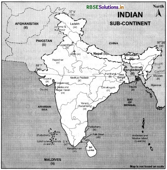
(ii)Pakistan, Nepal, Bhutan, Bangladesh, Sri Lanka, Maldives, Afghanistan, China, Myanmar.
(iii)Gujrat, Rajasthan, Madhya Pradesh, Chhattisgarh, Jharkhand, West Bengal, Tripura, Mizoram
(iv) 37°6’ N
(v) 8°4’ N
(vi) Western 68°7’E, Eastern 97°25’E
(vii) Kanniyakumari
(viii) The Palk Strait
(ix)Andaman & Nicobar Island, Chandigarh, Dadra & Nagar Haveli, Daman & Diu, Lakshadweep, Delhi, Puducherry
Project/Activity
(i) Find out the longitudinal and latitudinal extent of your state.
Answer:
Question to be attempted by students with the help of atlas or the internet.
(ii) Collect information about the ‘Silk Route’. Also find out the new developments, that are improving communication routes in the regions of high altitudes.
Answer:
The Silk route is an ancient international trade route which connected China with the mediterranean sea. Silk route gets its name from the lucrative Chinese silk trade. It was formed during the Han Dynasty. China.was the first country in the world to produce silk fabric. It was through this trade route that China’s silk fabric was introduced into western countries.
Also the skills of paper-making, printing, silkworms breeding, silk spinning, and Chinese inventions such as gunpowder and compass reached the West Communication satellites such as SATCOM are being increasingly used for communication. Satellite phones and mobile phones are the popular means of communication that use communication satellites. Internet facilities with Wi-Fi have also developed in regions of high-altitude facilitating services like e-mails and video conferencing.

- RBSE Class 9 Social Science Important Questions Civics Chapter 1 लोकतंत्र क्या? लोकतंत्र क्यों?
- RBSE Solutions for Class 9 Social Science Geography Chapter 5 Natural Vegetation and Wildlife
- RBSE Solutions for Class 9 Social Science Geography Chapter 6 Population
- RBSE Solutions for Class 9 Social Science in Hindi Medium & English Medium
- RBSE Class 9 Social Science Important Questions in Hindi & English Medium
- RBSE Class 9 Social Science Notes in Hindi & English Medium Pdf Download
- RBSE Class 7 Social Science Important Questions History Chapter 9 क्षेत्रीय संस्कृतियों का निर्माण
- RBSE Class 9 Social Science Important Questions Civics Chapter 1 What is Democracy? Why Democracy?
- RBSE Class 9 Social Science Notes Civics Chapter 4 संस्थाओं का कामकाज
- RBSE Class 9 Social Science Important Questions Economics Chapter 4 भारत में खाद्य सुरक्षा
- RBSE Solutions for Class 9 Social Science Civics Chapter 5 लोकतांत्रिक अधिकार