RBSE Class 7 Social Science Important Questions Geography Chapter 3 Our Changing Earth
Rajasthan Board RBSE Class 7 Social Science Important Questions Geography Chapter 3 Our Changing Earth Important Questions and Answers.
Rajasthan Board RBSE Solutions for Class 7 Social Science in Hindi Medium & English Medium are part of RBSE Solutions for Class 7. Students can also read RBSE Class 7 Social Science Important Questions for exam preparation. Students can also go through RBSE Class 7 Social Science Notes to understand and remember the concepts easily. Go through these प्लेट क्यों घूमती है and get deep explanations provided by our experts.
RBSE Class 7 Social Science Important Questions Geography Chapter 3 TOur Changing Earth
Multiple Choice Questions
Question 1.
Which the following is an example of the endogenic force is:
(a) River
(b) Volcano
(c) Wind
(d) Glacier
Answer:
(b) Volcano
Question 2.
The force responsible for mountain building is:
(a) Endogenic force
(b) Exogenic force
(c) Coriolis force
(d) Gravitational force
Answer:
(a) Endogenic force

Question 3.
Debris of boulders and coarse material carried by glacier are called:
(a) alluvial
(b) silt
(c) dunes
(d) moraines
Answer:
(d) moraines
Question 4.
One of the forces which causes movement of earth is:
(a) Endogenic force
(b) Coriolis force
(c) Armed force
(d) Atmospheric force
Answer:
(a) Endogenic force
Question 5.
The lithospheric plates are continuously moving due to:
(a) molten magma
(b) deforestation
(c) rainfall
(d) volcanic activities
Answer:
(a) molten magma
Fill in the blanks
Question 1.
The ............... is broken into a number of plates known as the Lithospheric plates.
Answer:
lithosphere
Question 2.
The movement of the ............... causes changes on the surface of the earth.
Answer:
plates,
Question 3.
............... forces sometimes produce sudden movements and at the other times produce slow movements.
Answer:
Endogenic
Question 4.
Movements like ............... and ................ cause mass destruction over the surface of the earth.
Answer:
earthquakes
Question 5.
The place in the crust where the movement starts is called the ...............
Answer:
focus.
True/False
Question 1.
A volcano is a vent in the earth’s crust through which molten material erupts.
Answer:
True
Question 2. Exogenic forces sometimes "produce sudden movements and 'at the other times produce slow movements.
Answer:
False.
Question 3.
The place on the surface abovethe focus is called epicentre.
Answer:
True
Question 4.
Erosion is the breaking up-6f the socks on the earth’s surface.
Answer:
True
Question 5.
S waves are also known as longitudinal waves.
Answer:
False.
Match the column
|
Column A |
Column B |
|
1. Highest waterfall |
(a) Africa |
|
2. Niagra falls |
(b) longitudinal waves |
|
3. Victoria falls |
(c) Venezuela |
|
4. P waves |
(d) surface waves |
|
5. L waves |
(e) North America |
Answer:
|
Column A |
Column B |
|
1. Highest waterfall |
(c) Venezuela |
|
2. Niagra falls |
(e) North America |
|
3. Victoria falls |
(a) Africa |
|
4. P waves |
(b) longitudinal waves |
|
5. L waves |
(d) surface waves |
Very Short Answer Type Questions
Question 1.
What is Levee?
Answer:
The natural uplifted part of flood plain along the river formed due to deposition of silt by river is called a Levee.
Question 2.
How are sea arches formed?
Answer:
When the cavities of sea caves become bigger and bigger and only the roof of the caves remain, thus forming sea arches.
Question 3.
How are stacks formed?
Answer:
When erosion touches sea arches and it breaks the roof and the roof falls. Then only the walls remain, the remaining portions are called stacks.
Question 4.
Define sea cliffs.
Answer:
The steep rocky coast rising almost vertically above sea water is called sfea cliffs.
Question 5.
How are beaches formed?
Answer:
The sea waves deposit sediments along the shores forming beaches.
Question 6.
What do you mean by Lithospheric plates?
Answer:
The Lithosphere is broken into a number of plates known as the Lithospheric plates.
Question 7.
What are three types of earth-quake waves?
Answer:
- P waves
- S waves
- L waves
Question 8.
What is volcano?
Answer:
A volcano is a vent in the earth’s crust through which molten erupts suddenly.
Question 9.
Which machine measure earthquake?
Answer:
Seismograph.
Question 10.
Where is the world’s highest waterfall located?
Answer:
The highest waterfall is Angel falls of Venezuela in South America.
Question 11.
How is waterfall formed?
Answer:
When the river tumbles at steep angle over very hard rocks or down a steep angle over very hard rocks down a steep valley side it forms a waterfall.
Question 12.
What do you mean by loess?
Answer:
When the grains of sand are very fine and light, the wind can carry it over long distances. When such sand is deposited in large areas it is called loess.
Question 13.
How is delta formed?
Answer:
The collection of sediments from all the mouths forms a delta.
Short Answer Type Questions
Question 1.
How do Lithospheric plates move?
Answer:
The lithospheric plates move very slowly, just a few millimeters every year. This is because of the movement of the molten magma inside the earth. The molten magma inside the earth moves in circular motion.
Question 2.
How is an earthquake measured?
Answer:
Earthquake is a tremor on earth’s surface due to sudden release of energy from the interior of the Earth. An earthquake is measured with a machine called a seismograph. The magnitude of the earthquake is measured on the Richter scale, developed by Charles Richter in 1935. An earthquake can be classified on the basis of its seismic intensity.
Long Answer Type Questions
Question 1.
Why is action of wind more prominent in arid and semi arid regions?
Answer:
The action of wind is more prominent in arid and semi arid areas due to several reasons:
- The wind is dry and light; hence, blows at a greater speed.
- Because of greater speed, it has more velocity to erode and carry away more material.
- Lack of trees in this region means there are less barriers in the flow of winds.
- Dry soil is loose and in the absence of vegetation, it is difficult to hold it down so it is easily carried away.
Question 2.
With the help of diagram show the features of sea waves.
Answer:
The features formed by sea waves in the coastal areas are as follows:
- sea Caves: Sea waves continuously strike at the rocks. Cracks develop. Over the time they become larger and wider. Thus, hollow like caves are formed on the rocks. They are called sea caves.
- Sea Arches: When these cavities become bigger and bigger only the roof of the caves remains, thus forming sea arches.
- Stacks: Further, erosion breaks the roof and only walls are left. These wall like features are called stacks.
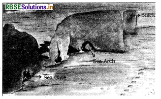
- Sea Cliff: The steep rocky coast rising almost vertically above sea water is called sea cliff.
- Beaches: The sea waves deposit sediments along the shores forming beaches.
Question 3.
Give a detailed account of the features fprmed by wind and ice.
Answer:
(i) The features formed by the wind are as ahead:
(a) Mushroom Rocks: In deserts, you can see rocks in the shape of a mushroom, commonly called mushroom rocks. Winds erode the lower section of the rock more than the upper part. Therefore, such rocks have narrower base and wider top.
(b) Sand Dunes: When the wind blows, it lifts and transports sand from one place to another. When it stops blowing, the sand falls and gets deposited in low hill-like structures. These are called sand dunes.
(c) Loess: When the grains of sand are very fine and light, the wind can carry it over very long distances. When such sand is deposited in large areas, it is called loess.
(ii) The features formed by ice are as follows:
(a) Lakes: Glaciers carve out deep hollows. As the ice melts, they get filled up with water and become beautiful lakes in the mountains.
(b) Glacial Moraines: The material carried by the glacier such as rocks big and small, sand and silt gets deposited. These deposits form glacial moraines.
Question 4.
Write a short note on ‘Work of a River’.
Answer:
The running water in the river erodes the landscape. When the river tumbles at a steep angle over very hard rocks or down a steep valley side, it forms a waterfall. As the river enters the plain, it twists and turns forming large bends known as meanders. In due course of time, the meander loop cuts off from the river and forms a cut-off lake, also called an ox-bow lake. At times the river overflows its banks. This leads to the flooding of the neighbouring areas.
As it floods, it deposits layers of fine soil and other material called sediments along its banks. This leads to the formation of a flat fertile floodplain. The raised banks are called levees. As the river approaches the sea, the speed of the flowing water decreases and the river begins to break up into a number of streams called distributaries. The river becomes so slow that it begins to deposit its load. Each distributary forms its own mouth. The collection of sediments from all the mouths forms a delta.

- RBSE Class 7 Social Science Notes in Hindi & English Medium Pdf Download
- RBSE Class 7 Social Science Important Questions in Hindi & English Medium
- RBSE Solutions for Class 7 Social Science in Hindi Medium & English Medium
- RBSE Solutions for Class 7 Social Science Civics Chapter 8 बाज़ार में एक कमीज़
- RBSE Class 7 Social Science Important Questions Civics Chapter 9 समानता के लिए संघर्ष
- RBSE Class 7 Social Science Important Questions Civics Chapter 8 बाज़ार में एक कमीज़
- RBSE Solutions for Class 7 Social Science Civics Chapter 9 समानता के लिए संघर्ष
- RBSE Class 7 Social Science Important Questions Civics Chapter 7 हमारे आस-पास के बाज़ार
- RBSE Solutions for Class 7 Social Science Civics Chapter 7 हमारे आस-पास के बाज़ार
- RBSE Solutions for Class 7 Social Science Civics Chapter 6 संचार माध्यमों को समझना
- RBSE Class 7 Social Science Important Questions Civics Chapter 6 संचार माध्यमों को समझना