RBSE Class 6 Social Science Important Questions Geography Chapter 4 Maps
Rajasthan Board RBSE Class 6 Social Science Important Questions Geography Chapter 4 Maps Important Questions and Answers.
Rajasthan Board RBSE Solutions for Class 6 Social Science in Hindi Medium & English Medium are part of RBSE Solutions for Class 6. Students can also read RBSE Class 6 Social Science Important Questions for exam preparation. Students can also go through RBSE Class 6 Social Science Notes to understand and remember the concepts easily. The class 6 social science chapter 3 question answer are curated with the aim of boosting confidence among students.
RBSE Class 6 Social Science Important Questions Geography Chapter 4 Maps
Multiple Choice Questions
Question 1.
The brown colour is used for showing
(a) Water Bodies
(b) Plateaus
(c) Plains
(d) Mountains
Answer:
(d) Mountains

Question 2.
A physical map shows
(a) natural features of the earth
(b) different countries and states of the world
(c) distribution of forests
(d) both (a) and (b).
Answer:
(a) natural features of the earth
Question 3.
Which one is not an intermediate direction?
(a) North-East (NE)
(b) West
(c) South-West (SW)
(d) North-West (NW).
Answer:
(b) West
Question 4.
Maps can be classified according to
(a) scale
(b) purpose of map
(c) both (a) and (b)
(d) none of these.
Answer:
(c) both (a) and (b)
Fill in the blanks
Question 1.
A ................ is used to show large areas like continents or countries on a paper.
Answer:
small scale
Question 2.
Three components of maps are ................ , ................ and ................
Answer:
distance, directon and symbol
Question 3.
Maps have a ................ language that can be understood by all.
Answer:
universal
Question 4.
Rough drawing which drawn without scale is called ................
Answer:
Sketch map
Question 5.
Maps are more informative than a ................
Answer:
globe.
True/False
Question 1.
A globe is used to study the Earth as a whole.
Answer:
True.
Question 2.
Political maps show natural features of the Earth.
Answer:
False
Question 3.
A large scale map is used to show large areas like countries on paper.
Answer:
False
Question 4.
There are four intermediate directions.
Answer:
True.
Match the column
|
Column A |
Column B |
|
1. Directions and distance play an important role in |
(a) scale |
|
2. A sketch usually does not show all the details of the |
(b) handle |
|
3. A plan shows the details of a very small area on a large |
(C) maps |
|
4. Maps can have more information and are easier to |
(d) arrow |
|
5. On the map, the north direction is shown by |
(e) area |
Answer:
|
Column A |
Column B |
|
1. Directions and distance play an important role in |
(C) maps |
|
2. A sketch usually does not show all the details of the |
(e) area |
|
3. A plan shows the details of a very small area on a large |
(a) scale |
|
4. Maps can have more information and are easier to |
(b) handle |
|
5. On the map, the north direction is shown by |
(d) arrow |
Very Short Answer Type Questions
Question 1.
What is an atlas?
Answer:
An atlas is a collection of maps.
Question 2.
Who was the first to represent the Earth as a sphere?
Answer:
The first Greek to draw a world map using the assumption of a spherical Earth was Eratoshenes.
Question 3.
How do we draw maps in present times?
Answer:
Presently, maps are drawn on computers. These maps are very accurate.
Question 4.
What is called the northern line?
Answer:
Maps usually contain an arrow marked with the letter “N” at the upper right hand comer. This arrow shows the north direction and is called the northern line.
Question 5.
What is a compass?
Answer: A compass is an instrument used for navigation and orientation that shows direction relative to the geographic cardinal directions.
Question 6.
Which direction helps to find other directions?
Answer:
North direction helps to find other directions.
Question 7.
What are conventional symbols?
Answer:
Some symbols have a fixed meaning and are understood uniformly throughout the world. Such symbols are known as conventional symbols.
Question 8.
Which map shows the capital, cities and states?
Answer:
The political map shows the capital, cities and states.
Question 9.
Why is scale important on a map?
Answer:
The scale helps to calculate the distance between any two places on a map.
Question 10.
What colours are used for the following:
(1) Mountains,
(2) Plains,
(3) Plateaus
(4) Water bodies.
Answer:
(1) Mountains-Brown
(2) Plains-Green
(3) Plateaus-Yellow
(4) Water Bodies-Blue.
Question 11
Generally, which colour is shown in the water reservoirs of river, drain, sea etc?
Answer:
Blue colour.
Question 12
Define Plan.
Answer:
A plan is a drawing of a small area on a large scale.
Short Answer Type Questions
Question 1.
Differentiate between a small, scale map and a large scale map?
Answer:
|
Small scale maps |
Large scale maps |
|
They cover a large area of the Earth and show only a small amount of details. |
They cover a small area of the Earth and show a large amount of detail about a small area. |
|
Example: Maps of continents and coun¬tries are drawn on a small scale map. |
Example: Map of a colony or a street. |
Question 2.
How can we find directions with the help of a compass?
Answer:
The direction of a place is traced out with the help of a compass. Its magnetic needle always points in a north-south direction. Following are the given steps to find out the directions:
- Hold the compass horizontally in front of you with the direction of the travel arrow pointing away from you.
- Use this arrow to guide you to your destination.
- Turn your body until the north end of the magnetic needle is aligned with the orienting needle.
- And you’ll be properly oriented toward the destination.
Question 3.
What is a scale? Give example.
Answer:
Scale is the ratio between the actual distance on the ground and the distance shown on the map. For example, the distance between your home and school is 10 km. If you show this 10 km distance by 2 cm on a map, it means 1 cm on the map will show 5 km on the ground. The scale of your map will be 1 cm = 5 km.
Question 4.
What are the limitations of study of a globe?
Answer:
However, globe has limitations as well. A globe can be useful when we want to study the earth as a whole. But, when we want to study only a part of the earth, as about our country, states, districts, towns and villages, it is of little help. In such a situation we use maps.
Question 5.
Briefly describe the compo¬nents of the map.
Answer:
There are three components of the map
(1) Distance-A major component of the map is distance. The distance of real places is minimised with the help of a scale on the map.
(2) Direction-The north direction is shown by an arrow marked with the letter ‘N’ at the upper right-hand corner of the map. Other directions can also be traced from this.
(3) Symbols-Symbol is the third important component of a map. The actual shape and size of different features such as buildings, roads, bridges, trees, railway lines or a well are shown by symbols.
Question 6.
What is a compass? Draw and explain.
Answer:
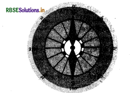
We can find out the direction of a place with the help of a compass. It is an instrument used to find out main directions. Its magnetic needle always points towards north-south direction. From this, other directions are also known easily.
Question 7.
How are different colours used as symbols?
Answer:
Various colours are used for the purpose of symbols. For example, generally blue is used for showing water bodies, brown for mountains, yellow for plateau and green is used for plaine.
Long Answer Type Questions
Question 1.
What is a map? Discuss various types of maps.
Answer:
A map is a representation or a drawing of the Earth's surface or a part of it is drawn on a flat surface according to a scale. Maps are of various types. Some of them are:
- Physical maps-Maps showing natural features of the earth such as mountains, plateaus, plains, rivers, oceans, etc. are called physical or relief maps.
- Political maps-Maps showing cities, towns, villages, different countries and states of the world with their boundaries are called political maps.
- Thematic maps-Maps that focus on specific information; such as road maps, rainfall maps, maps showing the distribution of forests, industries etc. are known as thematic maps.
Question 2.
State the importance of symbols in a map.
Answer:
- It is not possible to draw the actual shape and size of different features such as buildings, roads, bridge, trees, railway lines or a well on a map. So, they are shown using certain letters, shades, colours, pictures and lines.
- These symbols give a lot of information in a limited space. Wtih the use of these symbols, maps can be drawn easily and are simple to read. Even if we don’t know the language of an area, we can collect information from maps with the help of these symbols.
- These symbols are universal by all as there is an international agreement, regarding use of these symbols which are called conventional symbols.
Question 3.
Write advantages and disadvantages of the map.
Answer: Advantages of the map:
- It shows the small area in detail.
- It can show many facts at the same time.
- It helps us to study, any one feature in detail (thematic maps).
- Information can be easily edited on a map according to the need.
- It can be folded and easily carried from one place to another.
Disadvantages of the map:
- The shape of the continents, countries and oceans are not of true shape.
- It is impossible to show the round shape completely on a flat surface.
- Maintenance of paper maps is difficult.
Question 4.
What are the conventional symbols?
Answer:
It is not possible to draw on a map the actual shape and size of different features such as buildings, roads, bridges, trees, railway lines or a well. So, they are shown by using certain letters, shades, colours, pictures and lines.
Maps have a universal language that can be understood by all. There is an international agreement regarding the use of these symbols. These are called conventional symbols.

- RBSE Class 6 Social Science Important Questions Geography Chapter 8 भारत : जलवायु, वसस्पति तथा वन्य प्राणी
- RBSE Class 6 Social Science Notes in Hindi & English Medium Pdf Download
- RBSE Class 6 Social Science Important Questions in Hindi & English Medium
- RBSE Solutions for Class 6 Social Science in Hindi Medium & English Medium
- RBSE Class 6 Social Science Important Questions History Chapter 11 Buildings, Paintings and Books
- RBSE Class 6 Social Science Important Questions Civics Chapter 5 Panchayati Raj
- RBSE Class 6 Science Important Questions Chapter 16 Garbage In, Garbage
- RBSE Class 6 Social Science Important Questions History Chapter 3 In the Earliest Cities
- RBSE Class 6 Social Science Important Questions Civics Chapter 9 Urban Livelihoods
- RBSE Class 6 Social Science Important Questions Civics Chapter 8 Rural Livelihoods
- RBSE Class 6 Social Science Important Questions Civics Chapter 7 Urban Administration