RBSE Class 11 Geography Important Questions Chapter 9 Solar Radiation, Heat Balance and Temperature
Rajasthan Board RBSE Class 11 Geography Important Questions Chapter 9 Solar Radiation, Heat Balance and Temperature Important Questions and Answers.
Rajasthan Board RBSE Solutions for Class 11 Geography in Hindi Medium & English Medium are part of RBSE Solutions for Class 11. Students can also read RBSE Class 11 Geography Important Questions for exam preparation. Students can also go through RBSE Class 11 Geography Notes to understand and remember the concepts easily.
RBSE Class 11 Geography Important Questions Chapter 9 Solar Radiation, Heat Balance and Temperature
Multiple Choice Questions
1. What is the value of solar constant?
(A) 1.91 Calories
(B) 1.92 Calories
(C) 1.93 Calories
(D) 1.94 Calories.
Answers:
(D) 1.94 Calories.

2. How much solar energy is lost in atmosphere?
(A) 45 %
(B) 47 %
(C) 49 %
(D) 51 %.
Answers:
(C) 49 %
3. During Aphelion the distance between sun and earth?
(A) 930 lakh miles
(B) 940 lakh miles
(C) 950 lakh miles
(D) 960 lakh miles.
Answers:
(B) 940 lakh miles
4. The temperature decreases with height at the rates
(A) 1°C for 165 metres
(B) 1°C for 160 metres
(C) 1°C for 165 metres
(D) 1°C for 170 metres.
Answers:
(C) 1°C for 165 metres
5. Which year is considered the hottest year?
(A) 1950
(B) 1952
(C) 1955
(D) 1960.
Answers:
(C) 1955
6. Where is the highest range of temperature formed?
(A) Verkhoyansk
(B) Yaladi Voslock
(c) St. John
(D) Greenlane.
Answers:
(A) Verkhoyansk
7. What is the energy that the earth receives from the sun?
(A) Temperature
(B) Energy
(C) Sunset
(D) Solar rediation.
Answers:
(C) Sunset
8. The unit is used to measure sunlight?
(A) Degree Fahrenheit
(B) Percent
(C) Colorie
(D) Degree Centigrade.
Answers:
(C) Colorie
9. The energy radiated by the earth’s surface is called?
(A) Sunset
(B) Solar radiation
(C) Temperature
(D) Earthly or physical radiation.
Answers:
(D) Earthly or physical radiation.
10. The sun’s rays shine vertically on the Tropic of Cancer—
(A) 21 March
(B) 23 September
(C) 22 December
(D) 21 June.
Answers:
(D) 21 June.
Very Short Answer type Questions
Question 1.
What is the speed of sun’s rays?
Answer:
3 lakh kms per second.
Question 2.
Which is the main source of heat for the earth?
Answer: Sun.
Question 3.
What is the normal lapse rate of temperature?
Answer:
1° C for 165 metres.
Question 4.
Which place experiences the highest annual range of temperature?
Answer:
Verkhoyansk (Siberia).
Question 5.
In which natural region, is annual range of temperature low?
Answer:
Equatorial region.
Question 6.
What does the term isotherm mean?
Answer:
Lines of equal temperature.
Question 7.
Name three processes involved in heating the atmosphere.
Answer:
Conduction, Convection and Radiation.
Question 8.
What are the two causes of global warming?
Answer:
The burning of fuels and deforestation.
Question 9.
Name the type of climate found in coastal areas.
Answer:
Maritime (equable).
Question 10.
Name the type of climate found in interior regions.
Answer:
Continental.
Short Answer Type Questions
Question 1.
‘The amount of heat received by different parts of the earth is not same’. Explain.
Answer:
There is differential heating and cooling of land and water. No part remains hot for a long time. Similarly, Cooling is not observed for a long time. So the different parts do not have the same amount of temperature.
Question 2.
Name the factors which cause variation in insolation.
Answer:
The following factors cause the variation in insolation during a day or a season or in a year :
- Rotation of the earth
- The angle of inclination of sun’s rays
- The length of the day
- Transparency of the atmosphere and
- Relief of the land.
Question 3.
Explain the difference between insolation and terrestrial radiation.
Answer:
Incoming solar radiation on to the earth is called insolation. It is received in short wave length. The earth in turn radiates the heat back to the atmosphere in long waves. This is called terrestrial radiation.
Question 4.
“The annual insolation received by the; y earth on January 3rd is slightly more than the! amount received on July 4th.” Why?
Answer:
During the revolution around the sun, the earth is farthest from the sun-152 million kms away on July 4th. This position of the earth is called aphelion. On January 3rd, the earth is nearest to the sun-147 million kms away. This position is called perihelion. Therefore the annual insolation received by the earth on January 3rd is slightly more than the amount received on July 4th.
Question 5.
What do you mean by Albedo?
Answer:
Insolation is reflected by clouds and the earth. This combined reflection sends back some insolation into space. This solar radiation is called Albedo.
Question 6.
How is atmosphere heated?
Answer:
The atmosphere is not heated directly by the sun’s rays but it is indirectly heated by the radiation of the earth below. Conduction, convection and radiation are the main processes of heating the atmosphere. The land surface is heated by the sun’s rays. The lower layers are heated through outgoing radiation from the land. When the lower layers get heated, these expand and rise upward as convection currents. These distribute the heat of the lower layers to upper layers.
Question 7.
Name the factors which affect the range of temperature of a place.
Answer:
- Latitude
- Distance from the sea
- Ocean currents
- Prevailing winds
- Soils
- Cloudiness.
Question 8.
What is inversion of temperature?
Answer:
Inversion of Temperature. Under normal conditions, the temperature decreases with increasing height at the rate of 1°C per 165 metres. This is known as ‘Normal lapse rate. ’ But sometimes, the conditions are reverse so that the temperature increases with height locally and temporarily. This condition in which the colder air is nearer the earth and the warmer air above is called inversion of temperature.
Question 9.
Explain the importance of insolation.
Answer:
Sun is the most important source of atmospheric heat. Sun’s diameter is more than 100 times the Earth’s diameter and a surface temperature of more than 10,000°F. The heat waves radiate from the sun in all directions at a speed 1,86,000 miles per second or 3 lakh kms per second. The solar radiation received by the earth is 1/2000 millionth part of solar output. Yet, this small amount is vital for our existence on the earth. It is estimated that, on the average the earth receives about 1.9 gms. calories per minute per sQuestion cm. This is known as ‘solar constant’. All the physical phenomena depend upon insolation. Winds and ocean currents originate due to insolation. The earth is habitable only due to insolation.
Question 10.
Explain the Green house effect of; atmosphere. ;
Answer:
The atmosphere is heated by the radiation from the earth’s surface below. This action is compared to that of a glass house or greenhouse in which vegetable and flowers are grown in polar areas. Glass house permits radiation to get in but does not allow radiation to escape out. Therefore, glass house is warmer from inside than outside. Atmosphere also acts like a blanket keeping the earth warm. It is known as green house effect of atmosphere. This is due to presence of carbon dioxide in atmosphere. Carbon dioxide has the ability to absorb earth radiation. The carbon dioxide layer acts as a glass roof of the green house. With the increase in carbon dioxide, the temperature of the earth is increasing. Due to this, the year 1955 was the hottest year in India during this century.
Question 11.
What is global warming? What are its causes? State its effects.
Answer:
Global warming. The burning of fossil fuels, (coal, gas, petroleum), the cultivation of soil, large scale industrialisation, rapid means of transport and deforestation has caused an imbalance in the atmosphere. These activities are increasing the amount of carbon dioxide. Thus, green house effect has raised the average temperature of the earth by 0.5°C. By the year 2000, the earth’s average temperature went up by 2°C. This is called global warming. Global warming is causing a rise in sea-levels due to melting of glaciers. It is threatening to submerge many coastal areas.
Question 12.
Why is atmosphere heated from below?
Answer:
The atmosphere is not heated directly by the sun’s rays. It is indirectly heated by long wave radiation from the below. The earth absorbs sun’s rays. The outgoing radiation heats the atmosphere.
Question 13.
Why is land heated and cooled quickly than water?
Answer:
The specific heat of water is 2.5 times that of land. So it requires more heat to heat up water. So water is heated slowly but land is heated quickly. Water is heated upto a great depth. So it radiates heat slowly. So water is cooled slowly but land is quickly cooled.
Review Questions - Give Reasons
Question 1.
Mountains are cooler than plains. Discuss.
Answer:
The temperature decreases with height at the rate of 1°C per 165 metres or about 6°C per kilometre. The atmosphere is heated by radiation from the earth below. Therefore, lower layers are warmer than higher layers. There is absence of water vapour and dust particles on high mountains. So there is unchecked radiation. That is why mountains are cooler than plains. Shimla is cooler than Delhi. Similarly, Nainital is cooler than Prayagraj.
Question 2.
“Sea coasts have equable climate.” Why?
Answer:
Land and Sea breezes are present in coastal areas. Due to these, summers are warm and winters are cool. It results in oceanic or equable climate. But extremes of temperature or continental climate is found in inland areas.
Question 3.
What are isotherms? Why are these reduced to sea-level?
Answer:
Isotherm is a combination of two words (iso = equal, therm = temperature). So Isotherms are imaginary lines joining the places of equal temperature reduced to sea level. Before drawing climatic maps, the temperatures are reduced to sea level to eliminate the effect of altitude. Isotherms show the distribution of temperature, as if the whole earth were a level plain. It shows the temperature of the place as it would be, if the place were at sea-level.
Question 4.
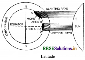
Vertical rays are hotter than slanting rays. Why?
Answer:
Vertical rays are hotter than slanting rays due to the following reasons :
(i) Vertical rays heat up a smaller surface. Hence the heat received per unit of area is large. On the other hand, slanting rays heat up a large area.
(ii) Vertical rays travel through a shorter distance in the atmosphere and the loss of heat is less. Slanting rays travel a longer distance through the atmosphere where much of its heat is absorbed by clouds, water vapours and dust particles.
Question 5.
‘Despite its location in higher latitudes, the coast of Norway is never frozen.’ Why?
Answer:
The areas situated in higher latitudes have a cold climate. In winter, these areas have temperatures below freezing point (CPC). But coast of Norway is never frozen. Its ports are ice free. North Atlantic Drift (Gulf Stream currents) flows along its coast. It is a warm current which raises the winter temperatures of this area.
Question 6.
‘In Rajasthan, the day temperatures are very high, while the night temperatures fall rapidly.’Why?
Answer:
Rajasthan is a sandy desert. Sandy soil is very sensitive to temperature changes. Sandy soils get heated and cooled more quickly than other soils. The day temperatures are very high. The night temperatures fall below freezing point. The daily range of temperature is very high.
Question 7.
“Why are the northern slopes of Himalayas cooler than its southern slopes?”
Answer:
The northern slopes of Himalayas are away from the sun. These slopes get oblique rays. These slopes are exposed to cold winds. These are shady slopes and are cooler. But the Southern slopes are Sun facing slopes. These get Sun’s rays more directly and also for longer periods. These are Sunny slopes and shelters from cold winds. So the Southern slopes of Himalayas are warmer than northern slopes.
Question 8.
Explain the relation between latitude and temperature of a place.
Answer:
Latitude and Temperature. The tem¬perature decreases gradually from the equator to poles. Vertical rays are hotter than slanting rays. Vertical rays heat up a smaller surface area and travel through a shorter distance in the dense atmosphere. Hence the heat received per unit area is large. On the other hand, slanting rays heat up a large area and travel through a longer distance in the atmosphere where much of its heat is absorbed by clouds, water vapours, dust particles. The equatorial region gets maximum temperatures as the sun’s rays fall vertical on the equator throughout the year. In polar areas the low temperatures are found due to more oblique and slanting rays. For example, Chennai is warmer than Kolkata.
Question 9.
Explain the effect of slope of the land on the temperature.
Answer:
South facing slopes are warmer than North facing slopes. The Northern slopes are exposed to cold winds; these mostly lie in shadow and are ‘Shady’ slopes; these slopes get oblique rays of the sun. But on the other hand, southern slopes are sheltered from cold winds. They receive sun’s rays more directly and also for longer periods; these are mostly ‘sunny’ slopes, the Southern slopes of the Himalayas (towards India) are warmer than the Northern slopes (towards Tibet).
Question 10.
Write a note on the temperature zones of the world. Draw a diagram to explain.
Answer:
The early Greek philosophers divided the globe into three regions on the basis of temperature and latitudes. These are known as temperature zones.
(i) Torrid zone. This zone lies between the Tropic of Cancer (2314°N) and the Tropic of Capricorn (23y2°S). The sun remains overhead in this zone and the temperatures are high throughout the year. It has tropical climates.
(ii) Temperate zone. It lies between 2314° and 6614° latitudes in both the hemispheres. It has a moderate climate. In the northern hemisphere, it lies between tropic of cancer and Arctic circle. In the Southern hemisphere, it lies between Tropic of Capricorn and Antarctic Circle.
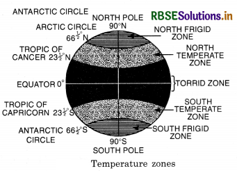
(iii) Frigid zone. It lies between 6614°N and North Pole in the northern hemisphere and in the southern hemisphere, it lies between 6614° S and South Pole. It is the polar region and extremely cold throughout the year.
Question 11.
Explain the difference between insolation and temperature of a place.
Answer:
Insolation is a form of energy. Insolation is incoming solar radiation received on the surface of the earth. It provides heat to the surface of earth. But temperature of a place is the heat present in air, one metre above the surface of earth. It is the temperature of the air. This air is heated up by radiation from the earth.
Question 12.
Define Insolation.
Answer:
Sun is the most important source of atmospheric heat, Sun’s diameter is more than 100 times the earth’s diameter and has surface temperature of more than 10,000°F. The heat waves radiate from the sun in all directions at a speed of 1,86,000 miles per second or 3 lakh kms per second. The solar radiation received by the earth is 1/2000 million part of solar output. Yet, this small amount is vital for our existence on the earth. It is estimated that, on the average, the earth receives about 1.9 gms. calories per minute per sQuestion cm. This is known as ‘solar constant’. Thus, insolation means ‘the incoming solar radiation received on the earth surface. ’The word insolation is a combination of three words (in + sol + ation) or “Incoming solar radiation.”
Question 13.
Name the two factors which control the amount of insolation.
Answer:
The two major factors controlling the amount of insolation received on the earth’s surface are :
- Intensity of Insolation or the Angle of incidence of sun rays.
- The duration of solar radiation or length of the day.
All the places on the same parallel receive same amount of insolation because the length of day and angle of the sun’s rays are equal on all parts of same parallels.
Question 14.
Why do different parallels receive! different amount of insolation?
Answer:
The amount of insolation depends upon the angle of sun’s rays and length of day. The distribution of insolation varies from latitude to latitude due to above factors. The equator receives the maximum amount of insolation and it decreases from equator towards the poles. At poles the insolation received is only about 40% of that of the equator. Due to the spherical shape of the earth, inclination of axis and the revolution of the earth; the angle of the sun’s rays is different at different latitudes. The length of the day also varies with the latitude. Therefore, the different latitudes receive different amount of insolation.
Essay Type Questions
Question 1.
Describe the major factors which control the distribution of insolation on the earth.
Answer:
The distribution of insolation varies from latitude to latitude. Different parallels receive different amount of insolation. The following are the major factors which control the distribution of insolation:
1. Intensity of insolation or angle of incidence of sun’s rays. The intensity of insolation depends upon the angle of incidence of sun’s rays. Due to the spherical shape and inclination of the axis of the earth, the angle of sun’s rays varies from latitude to latitude. The sun shines vertically at the equator but the angle of sun’s rays decreases towards poles.
The vertical rays deliver more energy per unit area than oblique rays. Vertical rays heat up a smaller surface area and hence the heat received per unit area is large. Vertical rays travel in shorter distance through the atmosphere. The loss of heat through atmosphere is small. On the other hand the oblique rays are spread over a large area and the heat per unit area is much less. The oblique rays have to pass a greater distance through the atmosphere and it results in a large amount of loss of heat.
|
Angle of Incidence of sun’s rays |
Length of rays in atmosphere |
Intensity of insolation |
|
90° |
1.00 |
78% |
|
60° |
1.15 |
65% |
|
30° |
2.00 |
31% |
|
0° |
45.00 |
0% |
2. Duration of solar radiation of length of day. Due to the inclination of axis and the revolution of the earth, the length of day varies from place to place. The days are longer in summer and shorter in winter, as we go away from the equator. The longer the sun shines, the greater the amount of the insolation received. The two factors operate jointly. The length of the day and the angle of the sun’s rays are equal on all parts of the same parallel. Therefore, all places on the same parallel receive the same amount of the insolation.
3. Effect of atmosphere. The atmosphere weakens the insolation by the process of scattering, reflection and absorption. Dust particles, water vapours and gases reduce the amount of insolation. The oblique rays have to travel a greater distance through the atmosphere and it results in the larger amount of loss of heat.
4. The distance between the earth and the sun. The distance between the sun and the earth varies at several positions in its orbit. In January (Perehelion), the earth is only 165 million kms. away from the sun. In July (Aphelion), the earth is 170 million kms. away from the earth. More insolation is received by the earth when it is closer to the sun.
5. Number of Sun Spots. Number of sun spots increases and decreases with a period, with the result the solar output changes from time to time.
6. Distribution of Land and Water. Land and water do not receive equal amount of insolation. Land becomes quickly heated and cooled, while the water is slowly heated or cooled. Therefore, the amount of the insolation received on continents and oceans varies.
Question 2.
What factors control the horizontal distribution of temperature? Give examples.
Answer:
Temperature. Temperature means degree of hotness of a body. Temperature of a place means the temperature of the air at that place and is measured in shade. The horizontal distribution of temperature depends upon the following factors :
1. Latitude. The temperature decreases gradually from the equator to the poles. The intensity of insolation depends on the angle of incidence of sun’s rays. Vertical rays are hotter than slanting rays. Vertical rays heat up a smaller surface area and travel through a shorter distance in the dense atmosphere. Hence the heat received per unit area is large. On the other hand, slanting rays heat up a large area and travel through a longer distance in the atmosphere where much of its heat is absorbed by clouds, water vapours, dust particles. The equatorial region gets maximum temperature as the sun’s rays fall vertically over the equator throughout the year. In polar areas, the low temperature is found due to more oblique or slanting rays. For example, Chennai is warmer than Kolkata.
2. Altitude. The temperature decreases with increasing height above sea level. The temperature decreases at the rate of 1°C for every 500 feet or 1°C per 165 metres.
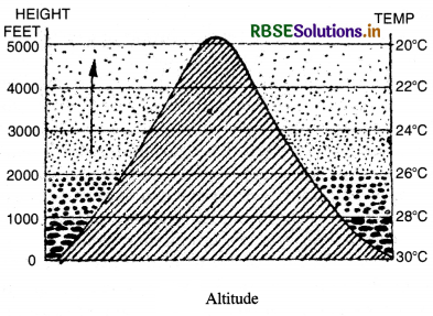
The atmosphere is mainly heated by conduction from the earth. Therefore, the lower layers nearer the earth are warmer than higher layers of the atmosphere. For this reason the mountains are cooler than plains. The air is rarefied and there is absence of dust particles and water vapour on mountains; so there is unchecked radiation. For example, Shimla is cooler than Ludhiana.
3. Distance from the Sea. The nearness to sea has moderating influence on the temperature of coastal areas. Maritime or equable temperatures are found in coastal areas. But extremes of temperatures with continental climate are found in inland areas remote from the sea. Due to the presence of land and sea breezes in coastal areas; the summers are warm and winters are cool. This is due to the differential heating and cooling of land and water. Land surfaces are heated more quickly than water. But a greater annual range of temperature is found as we go away from equator. The climate of Mumbai is more equable than that of Delhi.
4. Prevailing Winds. Prevailing winds affect the temperature of an area by transporting their heat and coldness. A wind from the sea lowers the summer temperature and raises the winter temperatures. The on-shore westerlies tend to moderate the temperatures of N. W. Europe. A wind from the land lowers the winter temperature and raises the summer temperature. The out-blowing cold winds from Central Asia cause a ‘cold wave’ in winter in North China.
5. Ocean Currents. Ocean currents modify the temperature of the winds blowing over them. Warm currents raise and cold currents lower the temperature of coastal areas. Winds blowing over the warm currents make coastal areas warm and moist. The gulf stream current makes winter moderate in N.W. Europe and keeps their ports ice free. Winds blowing over the cold currents lower the temperature and humidity. N.E. coast of Canada remains frozen during the major part of winter due to cold Labrador current.
6. Direction of the mountains. Mountains act as climatic barriers. The Himalayas check the cold winds coming from Central Asia and protect India from the cold wave. Tibet is surrounded by high mountain ranges and is cut off from oceanic influences.
7. Slope of the land. South facing slopes are warmer than North facing slopes. The northern slopes are exposed to cold winds; these mostly lie in shadow and are ‘shady’ slopes, these slopes get oblique rays of the sun. But on the other hand, southern slopes are sheltered from cold winds, these receive sun’s rays more directly and also for longer periods, these are mostly sunny slopes. The Southern slopes of the Himalayas (towards India) are warmer than the Northern slopes (towards Tibet).
8. Cloudiness and Rainfall. Clouds check sun’s rays and reduce the temperature during the day. At night, clouds check the outgoing radiation and do not allow the temperature to fall. Under clear skies, such as in deserts, very high day temperatures are recorded; but night temperatures fall rapidly. Heavy rain also helps to reduce the temperature.
9. Vegetation and Soils. Forests have a cooling effect on the air. Sandy soils are heated and cooled very quickly as in Rajasthan desert; but clay soils warm p or cool down more slowly.
Source Based Questions
1. Read the following paragraph and answer the questions given below:
Sun is the most important source of atmospheric heat. Sun’s diameter is more than 100 times the earth’s diameter and has surface temperature of more than 10,000° F. The heat waves radiate from the sun in all directions at a speed of 1,86,000 miles per second or 3 lakh km per second. The solar radiation received by the earth is 1/2000 million part of solar output. Yet, this small amount is vital for our existence on the earth. It is estimated that, on an average, the earth receives about 1.9 gm. calories per minute per sQuestion cm. This is known as ‘solar constant’. Thus, insolation means ‘the incoming solar radiation received on the earth surface’. The word insolation is a combination of three words (in + sol + ation) or “Incoming solar radiation.”
(i) Which of the following is an important source of atmospheric heat?
(a) Moon
(b) Sun
(c) Earth
(d) Jupiter
Answer:
(b) Sun
(ii) What does insolation mean?
(a) Incoming solar radiation
(b) Outgoing solar radiation
(c) Reflecting solar waves
(d) None of these
Answer:
(a) Incoming solar radiation
(iii) How many words are combined to form the word insolation?
(a) 2
(b) 3
(c) 4
(d) 5
Answer:
(b) 3
(iv) How many calories does the earth receive per minute per sq km?
(a) 1.5 gm
(b) 1.8 gm
(c) 1.9 gm
(d) 1.7 gm
Answer:
(c) 1.9 gm
2. Read the following paragraph and answer the given questions:
The early Greek philosophers divided the globe into three regions on the basis of temperature and latitudes. These are known as temperature zones. Torrid zone lies between the Tropic of Cancer 231/2°N and the Tropic of Capricorn 23!4°S. The sun remains overhead in this zone and the temperatures are high throughout the year. It has tropical climate.
Temperate zone lies between 231/2° to 6614° latitudes in both the hemispheres. It has moderate climate. In the northern hemisphere, it lies between Tropic of Cancer and Arctic Circle. Frigid zone lies between 6614° N and North Pole in the northern hemisphere and in the southern hemisphere, it lies between 6614° S and South Pole. It is the polar region and extremely cold throughout the year.
(i) Where is tropical climate found?
(a) Torrid zone
(b) Temperate zone
(c) Tropical zone
(d) Frigid zone
Answer:
(a) Torrid zone
(ii) Which zone has moderate temperature?
(a) Torrid zone
(b) Temperate zone
(c) Tropical zone
(d) Frigid zone
Answer:
(b) Temperate zone
(iii) Which of the following zone lies between 6614° N and North Pole?
(a) Torrid zone
(b) Temperate zone
(c) Tropical zone
(d) Frigid zone
Answer:
(d) Frigid zone
(iv) In which zone sun remains overhead?
(a) Temperate
(b) Tropical
(c) Torrid
(d) Frigid
Answer:
(c) Torrid
HOTS QUESTIONS
Question 1
Why are isotherms generally parallel to [Si) the parallel of lattitude in an East-West ’. direction?
Answer:
The isotherms generally tend east to west roughly parallel to the lines of latitudes. It is observed that the length of day the angle of sun’s rays are equal on all parts of the same parallel. All places on a parallel receive the same amount of insolation and have equal temperatures. Therefore, the isotherms joining the places of equal temperature run roughly parallel to the lines of latitude. Thus, due to the similarity between distribution of insolation and latitude, isotherms follow parallels of latitude.
SELF EVALUATION TEST
- What is insolation?
- What is daily range of temperature?
- What does the term isotherm mean?
- What is continental climate?
- Name the effects of global warming.
- Define the temperature of a place.
- What is inversion of temperature?
- What is global warming?
- What is the relation between latitude and temperature of a place?
- Describe the temperature zones

- RBSE Solutions for Class 12 Geography Chapter 11 अंतर्राष्ट्रीय व्यापार
- RBSE Solutions for Class 11 Geography Chapter 1 भारत - स्थिति
- RBSE Solutions for Class 11 Geography Chapter 3 पृथ्वी की आंतरिक संरचना
- RBSE Solutions for Class 8 Our Rajasthan Chapter 5 उद्योग
- RBSE Solutions for Class 11 Geography Chapter 2 संरचना तथा भूआकृति विज्ञान
- RBSE Solutions for Class 11 Geography Chapter 1 भूगोल एक विषय के रूप में
- RBSE Class 11 Geography Important Questions Chapter 7 Natural Hazards and Disasters
- RBSE Class 11 Geography Important Questions in Hindi & English Medium
- RBSE Class 11 Geography Important Questions Chapter 6 Soils
- RBSE Class 11 Geography Important Questions Chapter 5 Natural Vegetation
- RBSE Class 11 Geography Important Questions Chapter 4 Climate