RBSE Class 11 Geography Important Questions Chapter 7 Landforms and their Evolution
Rajasthan Board RBSE Class 11 Geography Important Questions Chapter 7 Landforms and their Evolution Important Questions and Answers.
Rajasthan Board RBSE Solutions for Class 11 Geography in Hindi Medium & English Medium are part of RBSE Solutions for Class 11. Students can also read RBSE Class 11 Geography Important Questions for exam preparation. Students can also go through RBSE Class 11 Geography Notes to understand and remember the concepts easily.
RBSE Class 11 Geography Important Questions Chapter 7 Landforms and their Evolution
Multiple Choice Questions
1. Which is the cause of formation of Horns in glaciated regions?
(A) Uplift
(B) Cirques all sides
(C) Erosion
(D) Weathering.
Answer:
(C) Erosion

2. In which course of river, a waterfall is formed?
(A) Upper
(B) Middle
(C) Lower
(D) Mouth.
Answer:
(A) Upper
3. Which feature is formed at the narrow- deep valley at mouth of a river?
(A) Delta
(B) Estuary
(C) Mouth
(D) Valley.
Answer:
(B) Estuary
4. Which is the characteristic of a river in its middle course?
(A) Down cutting
(B) Delta
(C) Side cutting
(D) Distributaries.
Answer:
(C) Side cutting
5. What is the value of solar constant?
(A) 1.91 calories
(B) 1.92 calories
(C) 1.93 calories
(D) 1.94 calories.
Answer:
(D) 1.94 calories.
6. How much solar energy is lost in atmorphere?
(A) 45%
(B) 47%
(C) 49%
(D) 51%.
Answer:
(C) 49%
7. During Aphelion, the distance between Sun and Earth?
(A) 930 lakh miles
(B) 940 lakh miles
(C) 950 lakh miles
(D) 960 lakh miles.
Answer:
(B) 940 lakh miles
8. The temperature decreases with height at the rate of
(A) 1°C for 150 meters
(B) 1°C for 160 meters
(C) 1°C for 165 meters
(D) 1°C for 170 meters.
Answer:
(C) 1°C for 165 meters
9. Which year is considered the hottest?
(A) 1950
(B) 1952
(C) 1955
(D) 1960.
Answer:
(C) 1955
10. Where is the highest range of temperature formed?
(A) Verkhoyansk
(B) Naladivoslock
(C) St John
(D) Greenland.
Answer:
(A) Verkhoyansk
Very Short Answer Type Questions
Question 1.
Name four features formed in upper course of a river.
Answer:
Gorges, Canyons, Rapids and Waterfalls.
Question 2.
Name the three stages of a river.
Answer:
Young, mature and old.
Question 3.
Name four features formed in the middle course of a river.
Answer:
Meanders, flood plains, levees and ox-bow lake.
Question 4.
Name a famous canyon.
Answer:
Grand Canyon on the Colorado river.
Question 5.
Name two river gorges in India.
Answer:
Sutlej gorge and Dihang gorge (Assam).
Question 6.
Name the highest waterfall in India.
Answer:
Jog Falls.
Question 7.
Name an important waterfall in North America.
Answer:
Niagra Falls.
Question 8.
What are meanders?
Answer:
The river loops are called Meanders.
Question 9.
Which is an ox-bow lake?
Answer:
The horse shoe shaped strip of water is called ox-bow lake.
Question 10.
What are the levees?
Answer:
The raised banks (by deposition) of the river.
Question 11.
Name a river where levees have been formed on its banks.
Answer:
River Hwang Ho (China).
Question 12.
What is a delta?
Answer:
A triangular piece of alluvial land formed at the mouth of a river.
Question 13.
Name the largest delta in the world.
Answer:
Ganges delta.
Question 14.
What are snow fields?
Answer:
The areas permanently covered with snow.
Question 15.
What is snowline?
Answer:
The height above which snow always exists.
Question 16.
What is a glacier?
Answer:
A tongue shaped large mass of moving ice.
Question 17.
What are icebergs?
Answer:
Huge masses of floating ice.
Question 18.
Name two main types of glaciers.
Answer:
- Mountain or Valley glaciers
- Continental glaciers.
Question 19.
Name a famous glacier in India.
Answer:
Siachen glacier.
Question 20.
What are cirques?
Answer:
Semi-circular hollows on the side of a mountain.
Question 21.
Give an example of a horn.
Answer:
Matter Horn in Alps.
Question 22.
What are fiords?
Answer:
Drowned glaciated valleys.
Question 23.
What is the retreat of a glacier?
Answer:
Melting of a glacier.
Question 24.
What are moraines?
Answer:
Hillocks of glacial deposits.
Question 25.
What are Drumlins?
Answer:
Oval shaped deposits like eggs in a basket.
Question 26.
What are eskers?
Answer:
Long narrow ridges of glacial deposits (sand and gravel).
Question 27.
Name the processes involved in wind erosion.
Answer:
- Undercutting
- Gully erosion
- Scratching
- Polishing.
Question 28.
Name three types of wind erosion.
Answer:
- Deflation
- Abrasion
- Attrition.
Question 29.
What is deflation?
Answer:
The complete lifting and blowing of fine dust by wind.
Question 30.
What is a blowout?
Answer:
A large depression formed by deflation.
Question 31.
What is the shape of mushrooms?
Answer:
Umbrella shaped.
Question 32.
What are Yardangs?
Answer:
Sharp pointed, steep-sided over-hanging ridges of hard rocks.
Question 33.
What are zeugens?
Answer:
Flat topped hard rocks over-hanging soft rocks.
Question 34.
What are inselbergs?
Answer:
These are steep-sided dome shaped pyramids formed by wind erosion.
Question 35.
What are sand dunes?
Answer:
Hills of wind blown sand.
Question 36.
Name an area in India where Barchans are found.
Answer:
Barmer (Rajasthan).
Question 37.
What are Seifs?
Answer:
Sword like long narrow ridges of sand in Sahara.
Question 38.
What is crest and trough?
Answer:
The highest part of the wave is called crest and the lowest part of the wave is called trough.
Question 39.
Name the different types of waves. Answer: Breaker (surf), swash, backwash, undertow. Question 40. What are cliffs?
Answer:
Steep slopes facing the sea are called cliffs.
Question 41.
How are sea caves formed?
Answer:
Due to undercutting at the base of the cliffs.
Question 42.
What are beaches?
Answer:
Beaches are coastal ridges of sand and gravel.
Question 43.
What is a lagoon?
Answer:
Lagoon is a shallow lake between the coast and the bar.
Short Answer Type Questions
Question 1.
Divide a River, from its source to its mouth, into different sections.
Answer:
The river takes its rise from high mountains. It travels over a long distance to reach the sea. From its source to its mouth, the river can be divided into three parts :
- The Upper or Mountain Course.
- The Middle or Valley Course.
- The Lower or Plain Course.
Question 2.
Describe the different types of erosion done by a river.
Answer:
The river erodes the land in several ways :
- Solution: It dissolves the soluble rocks like limestone.
- Side cutting: The river erodes its banks side ways.
- Downcutting: River cuts deep into the valley floor.
- Attrition: The river loads like pebbles collide into one another and are broken.
Question 3.
How is a ‘V’-Shaped Valley formed?
Answer:
A V-shaped valley is formed by the vertical erosion of the river. Side-cutting and down-cutting of the river-bed go on simultaneously. The valley is deepened as well as widened. In this way, a broad V-shaped valley is developed.
Question 4.
On what factors does the erosional work of the river depend?
Answer:
The erosional work of the river depends upon the following factors:
- Volume of water.
- Velocity of water.
- Load of the river.
- Slope of the river.
- The nature of the rocks.
Question 5.
Define the term “Snowline”. Why does the height of snowline differ in different parts of the world?
Answer:
Snowline is the height above which the snow never melts. It is as high as 2,000 metres in Alps. 5,000 metres in Himalayas, and 5,500 metres in the equatorial regions. It varies due to latitude and the nature of slope. It is higher in steep Southern slopes of the Himalayas than in the Northern slopes. Snowline is higher in areas of heavy snowfall.
Question 6.
What are the different types of Moraines?
Answer:
According to the place of deposition, the moraines are of following four types :
- Lateral Moraines
- Medial Moraines
- Terminal Moraines
- Ground Moraines.
Question 7.
Why is a tributary valley called a hanging valley?
Answer:
Many tributary glaciers from the mountains, join the main glacier. A tributary valley is formed at higher level than the main valley. The main glacier valley is deeper than the tributary valley. After the melting of ice, the tributary valley is left at a height much above the main valley. The stream in this valley ‘hangs’ above the main valley and forms a waterfall. Therefore, such tributary valleys are called hanging valleys.
Question 8.
Why does the middle of a glacier move faster than the sides?
Answer:
The velocity of the glacier varies in its different parts. The velocity of a glacier decreases sidewards and with depth. The velocity decreases due to friction with valley walls and the bottom floor. The load of the glacier also checks its velocity. There is absence of any friction and load in the middle of the glacier. Therefore, the middle of the glacier moves much faster than its sides.
Question 9.
How are ox-bow lakes formed?
Answer:
Ox-bow lakes. Sometimes the meanders take the shape of letter ‘S’. The river becomes alomost a complete circle. A former bend or loop of the river is separated from the flowing river. This horse shoe shaped strip of water is known as ox-bow lake. These lakes resemble the shape of an ox-bow. These are common on flood plains.
Question 10.
What is a Delta?
Answer:
Deltas. When a river enters the sea, it becomes very slow. It deposits all the load at its mouth. Such deposits of silt are known as Deltas. A delta is a triangular piece of alluvial land formed at the mouth of the river. It resembles in shape of the Greek letter delta, after which it is named. This name was used by the Greeks for the Nile delta.
Question 11.
Describe two types of deltas with examples.
Answer:
Types of Deltas :
(a) Regular Deltas. These are triangular, fan¬shaped deltas like Ganges delta.
(b) Bird’s Foot Deltas. These are irregular deltas which have several branches (distributaries) like the foot of a bird. The Mississippi delta is of this type and is also called a Crow’s nest delta.
Question 12.
Where are snowfields found and why?
Answer:
Snowfields are found on high mountains like the Alps, the Himalayas, etc. and in polar areas like Greenland and Antarctica. Snowfields are developed due to low temperatures, gentle slopes, refreezing of ice and protected hollows. Heavy snowfall, low melting and low rate of evaporation help in the development of snowfields.
Question 13.
How are loess deposits formed? Where are these found?
Answer:
Loess is a wind-born deposit. It is a yellow, porous, fertile deposit. The most extensive deposits are found in the N.W. China in Hwang-Ho Basin. It covers an area of 3 lakh sQuestion miles. Actually the word ‘loess’ comes from such a deposit in a village of France.
Question 14.
How are sea caves formed?
Answer:
Sea Caves. Sea caves are formed at the base of cliffs. Softer rocks at base are quickly eroded. Holes are produced in the cliff by wave action. These holes are enlarged to form sea caves. When two caves from opposite sides unite together, an arch is formed, like Needle’s Eye in England.
Question 15.
How are Lagoons and Spits formed?
Answer:
(i) Lagoon. Lagoon is a shallow lake between the coast and the bar. It is partially enclosed. It is connected with the open sea through a narrow gap. The Chilka and the Pulicat lakes on the East coast and Vembanad lake on Kerala coast are examples of lagoons in India.
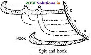
(ii) Spit. It is a tongue-shaped ridge of sediments deposited by waves. Its one end is attached to the land and the other end projects into the open sea. Sometimes a spit takes the shape of a hook.
Question 16.
How is a mushroom formed?
Answer: Mushroom-shaped rocks are produced by under-cutting of the wind. Under-cutting erodes the softer rocks at the base of rocks. It results in the formation of thin pillars. These rock pillars are called rock pedestals. Blocks of hard rocks rest on this pillar. An umbrella-shaped rock is formed. It is called mushroom or Gara in the Sahara.
Question 17.
Name the different lagoons found on the coasts of India.
Answer:
Many lagoons are formed on Kerala Coast (Malabar Coast) of India. Vembanad on west coast and Chilka, Publicat lake on East coast are unpolars.
Question 18.
What are the different surface forms of underground water?
Answer:
The underground water comes to surface in different forms like:
- Wells
- Springs
- Geysers
- Hot springs
- Mineral springs
- Artesian wells.
Question 19.
“There is absence of rivers on the surface, in Karst regions.” Discuss.
Answer:
In Karst regions, there is a general absence of surface drainage. Most of the surface water goes underground. Streams flow only for short distances over limestone areas. Then, these disappear underground. Dry valleys are formed on the surface. Streams develop a system of underground channels, called blind valleys. These streams reappear on the surface after some distance.
Question 20.
Distinguish between a geyser and hot spring.
Answer:
Geysers and hot springs are the surface forms of groundwater. A geyser is a spring of hot water and steam; but a hot spring contains only hot water. A geyser erupts hot water at regular intervals but a hot spring throws out water continuously. In a geyser, water is thrown out of a narrow pipe; but in a spring the water comes out of a fissure along the slope. In a geyser water is thrown out by superheated steam, with a force; but in a spring, water flows quietly.
Question 21.
Distinguish between a spring and an artesian well.
Answer:
A spring, generally, occurs along the dip of the slope; but an artesian well is formed in saucer-shaped synclinal rocks. In a spring, the permeable rock is found over an impermeable rock. In an artesian well, a permeable rock is formed between two impermeable rocks. In a spring water flows down the slope; but in an artesian well the water rises out automatically under hydraulic pressure. A spring as formed as a fissure in rocks, but in an artesian well, bore is drilled.
Question 22.
‘The river erosion depends upon the volume of water and the slope of the river.’ Discuss the statement.
Answer:
The river erosion depends upon the energy of the river. The volume of water and slope of the river increase the velocity of the river. Mountain rivers are swift and erode more. Large rivers develop broad-valleys. If the velocity of the river is doubled, the work of erosion is increased four times. The volume of the water increases the velocity of the river and the transporting power of the river.
Question 23.
On what factors does the formation of a delta depend?
Answer:
A delta is a triangular deposit of sediments at the mouth of a river. The formation of a delta depends upon the following conditions :
- A large upper course of the river.
- Absence of lakes in the course of the river.
- A gradual and gentle slope in the lower course.
- A large number of tributaries.
- Absence of tides and currents at the mouth of the river.
- A large amount of sediments.
Question 24.
What is the difference between a Gorge and a Canyon?
Answer:
A gorge is a narrow, deep opening of the river across a mountain. Due to hard rocks, side-cutting is absent. The river’s down-cutting leads to the formation of deep gorges, with almost vertical sides. But canyons are formed in dry areas. It has high vertical walls for long distances. The upper part of the canyon is wide due to weathering, but lower part is deeper due to rapid down-cutting.
Question 25.
How are waterfalls formed? Give examples with a diagram.
Answer:
Waterfalls. When river water falls suddenly from some height, along a vertical slope, it is known as a waterfall. Waterfalls are formed in mountainous regions; when
(a) a hard rock lies over a soft rock horizontally. Soft rocks are eroded rapidly.
(b) a hard rock lies vertically across a river.
Examples: A series of small and low falls are called rapids.
- The Niagara falls in North America 51 metres high is the most famous falls of the world.
- Jog falls in India is 260 metres high.
Question 26.
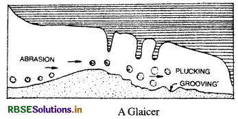
Define a glacier. How is it formed?
Answer:
Glaciers : Glaciers are rivers of ice.
Snowfields are the parents of the glaciers. Large mass of ice moves down the slopes as a river flows from high levels to lower levels. Thus, a glacier is a large mass of moving ice. It is tongue shaped. The end of the glacier is called snout. The movement of the glacier is due to the following factors:
- Pressure of the ice.
- Slope of the land.
- The pull of gravity.
Question 27.
How is a cirque formed?
Answer:
Cirque: Cirques are semi-circular hollows at the side of a mountain. The moving ice produces depression on the slopes of mountain. Plucking and frost wedging deepen and widen these depressions. An arm chair-shaped basin with a back wall is formed. These are known as cirques in France, corries in Scotland cwms in Wales and karrens in Germany. After the melting of ice a Tarn lake is formed in these cirques.
Question 28.
How are U-shaped valleys and Hanging 'valleys formed?
Answer:
U-shaped Valley. When a glacier enters a V- shaped valley, it changes its shape. The glacier widens and deepens the valley. A V-shaped valley thus becomes a U-shaped valley. A U-shaped valley has a wide flat floor and steep sides. St. Lawrence valley of North America is a U-shaped valley. Drowned glaciated valleys are known as fiords; as along the coast of Norway. Hanging Valley. A hanging valley is formed by a tributary glacier. The main glacier forms a much deeper valley than a tributary glacier. After the ice has melted, the tributary valley is left at a higher level than the main valley. Such valleys appear hanging above the main valley and are called hanging valleys.
Question 29.
What are moraines? Describe the different types of moraines.
Answer:
When a glacier melts, it is called the retreat of a glacier. Most of the material brought by glacier is deposited. These deposits are called Till or Drift. Glacier deposits its material in the form of hillocks. These are known as moraines. According to the place of deposition, moraines are of the following four types :
(i) Lateral Moraines: The material deposited on the two sides of the glacier is called a Lateral or Marginal moraine. It is a ridge of loose and broken material, rising to height of 100 feet.
(ii) Medial Moraines: These are formed by the meeting of two glaciers. When two glaciers meet at a point, the inner lateral moraines unite to form only one ridge. This ridge along the middle of the main glacier is called a medial moraine.
(iii) Terminal Moraines: When the glacier melts, some material is left behind at the snout of the glacier. This is called Terminal or End moraine. The narrow ridges extend across the valley in a semi-circular shape.
(iv) Ground Moraines : The material deposited under a glacier is called a ground moraine. These are found scattered on the Valley floor.
Question 30.
How are yardangs and zeugens formed?
Answer:
Yardangs. When hard and soft rocks are arranged vertically, sharp-pointed, steep-sided, over-hanging ridges of hard rocks are formed. These are called Yardangs. They are roughly parallel and run in the direction of the prevailing wind. These resemble ribs of a skeleton. These are generally 15 metres high and are found in the deserts of Central Asia. Zeugens. These are formed when soft rocks lie under the layer of hard rocks. Soft rocks are eroded and deep furrows are formed. The flat topped hard rocks overhang soft rocks. These are called zeugens. These resemble an inkpot with a cap.
Question 31.
How are Inselbergs formed?
Answer:
Inselbergs. Inselbergs are residual hills rising abruptly from the ground. These are composed of hard rocks like granite and gneiss. These have steep slopes and rounded tops. They look like dome-shaped pyramids. Inselberg is a German word meaning ‘Island mountain’. These are mostly found in Kalahari Desert.
Question 32.
What are sand dunes? How are these formed?
Answer:
Sand Dunes. Sand dunes are hills of wind¬blown sand. These are found in areas like :
- sandy coasts
- deserts
- sandy-shores of lakes
- along river banks.
Formation of a sand dune. The formation of a sand dune depends upon the following conditions :
- Large supply of sand.
- Strong winds.
- Obstruction in the way of wind.
Sand is deposited at the base of an obstruction like a bush. Gradually more sand is deposited. Sand is thrown on the leeward slope by strong wind. Thus, a sand dune is formed with a crest. It has a long gentle windward slope and a steep leeward slope with ripple marks.
Question 33.
Describe the different types of sand dunes.
Or
How are Barchans formed?
Answer: Types of sand dunes :
Sand dunes are of three major types:
(i) Longitudinal dunes. These are long narrow ridges of sand. These lie parallel to the direction of the prevailing wind. They are sometimes 100 metres high. These are called Seif (meaning sword) in Sahara.
(ii) Transverse dunes. These are formed perpendicular to the wind. They look like waves of sand. They are semi-circular in shape.
(iii) BarchAnswer: Barchan is a crescent or moon shaped sand dune formed in a perpendicular direction to the wind. The windward side is convex and gentle while the leeward side is concave and steep. Its ends are called Horns. These resemble a Sickle or Bow. The sand dunes keep on advancing and many towns and buildings have been buried under these sand dunes.
Question 34.
How are sea waves formed? Describe! the different types of waves.
Answer: The wind moves the water up and down. It causes folds on the surface of water, in the direction
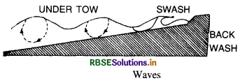
of the wind. Thus, waves arise and fall on the surface of water, caused by the friction of wind. The highest part of the wave is called crest, while the lowest part is called trough.
Types of Waves.
- Breaker. When the crest of the wave breaks into the shore, it is called a breaker or surf.
- Swash. When the water rushes up the beach, it is called swash.
- Backwash. When the water retreats from the beach, it is called a Backwash.
- Under Tow. When a strong current flows under the wave, away from the shore, it is called as Under Tow.
Question 35.
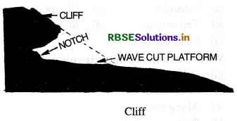
How is cliff formed?
Answer:
Cliff. Steep slopes facing the sea are called cliffs. Due to constant and direct strike of waves, a notch is formed at the base of the rocks. Due to under¬cutting, the notch is widened. An over-hanging rock projects seaward. After sometime, large blocks of rocks fall into sea. A vertical wall like cliff is formed
Comparison Questions
Question 1.
Distinguish between the following pairs :
(i) V-shaped valley and U-shaped valley
(ii) Delta and Estuary
(iii) Continental glaciers and Valley glaciers.
Answer:
(i) V-shaped valley and U-shaped valley
|
V-shaped Valley |
U-shaped Valley |
|
1. It is formed by the work of a river. |
1. It is formed by the work of a glacier. |
|
2. It is a narrow deep valley. |
2. It is a broad flat valley. |
|
3. The valley walls are not so steep. |
3. It has almost vertical walls. |
|
4. Its shape resembles the letter ‘V’. |
4. Its shape resembles the letter 'U'. |
|
5. It is originally formed by a river. |
5. It is formed when a glacier enters a 'V-shaped valley. |
|
Delta |
Estuary |
|
1. A delta is a tri-angular-shaped land formed at the mouth of a river. |
1. An estuary is a funnel-shaped channel formed at the mouth of a river. |
|
2. It is formed by deposition when there is absence of tides and currents. |
2. It is formed when deposition does not take place due to strong tides and currents. |
|
3. Ganges-Brahmputra form a large delta. |
3. Narmada, Tapti do not form deltas. |
|
(iii) Continental Glacier- |
Valley Glaciers |
|
1. These glaciers are found in polar regions. |
1. These glaciers are found on high mountains. |
|
2. These are found in Antarctica |
2. These are found over the Alps and the Himalayas. |
|
3. These cover large areas. |
3. These do not cover large areas. |
|
4. These are also called ice sheets. |
4. These are also called mountain glaciers. |
|
5. These are formed due to heavy snowfall. |
5. They rise from the snow fields. |
Question 2.
Distinguish between the following pairs :
- Longitudinal sand dunes and Transverse sand dunes.
- Work of wind and Work of river.
Answer:
|
(i) Longitudinal Sand dunes |
Transverse Sand |
|
1. These are long narrow ridges of sand. |
1. These are semi-circular sand dunes. |
|
2. These lie parallel to the direction of the wind. |
2. These lie perpendicular to direction of the wind. |
|
3. These are sometimes 100 metres high. |
3. These are sometimes only 50 metres high. |
|
4. They are called seif and resemble a sword. |
4. They look like large waves of sand. |
|
work of wind |
work of river |
|
1. The work of wind is important in deserts. |
1. The work of river is important in humid regions. |
|
2. Wind carries the material to long distances. |
2. The work of river is limited to its basin only. |
|
3. The work of wind depends on wind velo- city. |
3. The work of river depends on slope of the land. |
|
4. Wind-erosion is done at slow rate. |
4. River-erosion is done rapidly. |
Essay Type Questions
Question 1.
How are incised Meanders and River terraces formed?
Answer:
Incised or Entrenched Meanders.
Because of active lateral erosion, streams flowing over gentle slopes develop sinuous or meandering courses. It is common to find meandering courses over floodplains, and delta plains where stream gradients are very gentle. But very deep and wide meanders can also be found cut in hard rocks. Such meanders are called incised or entrenched meanders. Meander loops develop over original gentle surfaces in the initial stages of development of streams and the same loops get entrenched into the rocks normally due to erosion or slow, continued uplift of the land over which they start. River Terraces. River terraces are surfaces marking old valley floor or floodplain levels.
They may be bedrock surfaces without any alluvial cover or alluvial terraces consisting of stream deposits. River terraces are basically products of erosion as they result due to vertical erosion by stream into its own depositional floodplain. There can be a number of such terraces at different heights indicating former river bed levels. The river terraces may occur at the same elevation on either side of the rivers in which case they are called as paired terraces. When a terrace is present only on one side of the stream, and with none on the other side, or one at quite at a different elevation on the other side, the terraces are called non-paired terraces. Unpaired terraces are typical in areas of slow uplift of land or where the water column changes are not uniform along both the banks. The terraces may result due to
- receding water after a peak flow,
- change in hydrological regime due to climatic changes,
- tectonic uplift of land, and
- sea level changes in case of rivers closer to the sea.
Question 2.
Define a glacier. Describe the different types of glaciers.
Answer:
Glaciers. Glaciers are rivers of ice. Snow fields are the parents of the glaciers. Large mass of ice moves down the slopes as a river flows from high levels to lower levels. Thus a glacier is a large mass of moving ice. It is tongue shaped. The end of the glacier is called snout. The movement of the glacier is due to following factors:
- Pressure of the ice.
- Slope of the land.
- The pull of gravity.
Types of Glaciers. According to location, size and length, the glaciers can be divided into two major types:
1. Valley Glaciers. These glaciers rise from high mountains. These flow down the valley slopes. These are also called Mountain Glaciers. These glaciers were first found in the Alps. So these are also called Alpine Glaciers. Some valley glaciers are many kilometres long. The largest of the Indian glaciers is ‘Siachen’, which is 72 kms. long
2. Continental Glaciers. These are the largest of all glaciers. They cover vast areas in polar regions. These are also called Ice-sheets. About 25,000 years ago, large ice-sheets covered most of North America and Europe. At present, two major ice-sheets still exist in Greenland and Antarctica. Greenland covers an area of 7 lakh sQuestion miles, while Antarctica covers an area of 50 lakh sq miles.
Question 3.
Describe the work of sea waves as an agent of erosion, transportation and deposition.
Answer:
Sea waves. Work of sea is limited to coastal area. The most powerful agents of sea are waves. Currents, tides and storms help the sea waves in changing the face of the earth.
Work of sea waves :
Sea waves perform three types of work :
(a) Erosion
(b) Transportation
(c) Deposition. Erosion :
The erosive work of sea is mostly done by surf or breakers. They modify the coastline of an area. Sea waves can erode up to maximum depth of 200 metres. Marine erosion is performed in four ways :
- By hydraulic pressure. When the pressure of water in cracks, dislocates the blocks of rock.
- Abrasion. When waves strike the coast with rock fragments, these wear away the coasts.
- Attrition. When pebbles and stones collide into one another and are broken to pieces.
- Solution. When sea water dissolves soluble rocks like chalk and limestone.
The work of erosion done by sea waves depends upon certain factors :
- Nature of rocks.
- Power of waves and winds.
- Slope of the land.
- Presence of joints and faults.
- Depth of water.
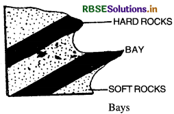
Coastal Features of Erosion :
(i) Bays. When hard and soft rocks occur alternately, bays and capes are formed. Soft rocks are eroded back to form bays. Hare rocks project as capes.
(ii) Cliff. Steep slopes facing the sea are called cliffs. Due to constant and direct strike of waves, a notch is formed at the base of the rocks. Due to under-cutting, the notch is widened. An overhanging rock projects seaward. After some time large blocks of rocks fall into sea, a vertical wall-like cliff is formed.
(iii) Sea Caves. Sea Caves are formed at the base of cliffs. Softer rocks at base are quickly eroded. Holes are produced in the cliff by wave action. These holes are enlarged to form sea caves. When two caves from opposite sides unite together, an arch is formed, like Needle’s eye in England.
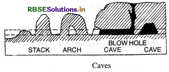
(iv) Blow Holes. Sometimes a hole is formed in the roof of a sea cave. Waves force air and water out of this hole. Such a hole is called a blow hole.
(v) Stack. Sometimes the arch of sea caves collapses. Rock pillars left standing seaward are called stacks. St. Kilda Stacks (England) are 627 feet high. Transportation. The load of sea waves is obtained from river, waves and material falling from the cliff. It is transported by waves, wind and currents in three ways :
- By solution.
- By traction (along the bed).
- By suspension.
Deposition. The eroded material is deposited by the waves along the coast. Some load of the waves is transported as undertow. This is deposited at some distance from the coast i.e. in off-shore region. Many features result from this marine deposition.
(i) Beaches. Beaches are the coastal ridges formed by the deposits of sand, gravel and pebbles. The beaches extend the land seaward.
(ii) Bars. A bar is a ridge (embankment) of sand, gravel built on the sea floor. Generally it runs parallel to the coast. When the supply of sand is great, the mouth of the bay is closed by these bars.
(iii) Lagoons. Lagoon is a shallow lake between the coast and the bar. It is partially enclosed. It is connected with the open sea through a narrow gap. The Chilika and the Pulicat lakes on the East coast and Vembanad Lake on Kerala coast are examples of Lagoons in India.
(iv) Spit. It is a tongue shaped ridge of sediments deposited by waves. Its one end is attached to the land and the other end projects into the open sea. Sometimes a spit takes the shape of a hook.
Source Based Questions
1. Read the following paragraph and answer the questions given below:
Running water is considered the most useful geomorphic agents in bringing about the degradation of the land surface, which receive heavy rainfall. This is specially in humid regions. There are two running water components such as overland flow on general land as a sheet; and a linear flow as streams and rivers in valleys. Mostly erosional landforms made by running water are associated with vigorous and youthful rivers flowing over steep gradients.
Gradually with time, stream channels over steep gradients turn gentler because of continued erosion and as a result, lose their velocity, facilitating active deposition. There may be depositional forms associated with streams flowing over steep slopes. But these phenomena will be on a small scale compared to those associated with rivers flowing over medium to gentle slopes. The gentler the river channels in gradient or slope, the greater is the deposition.
(i) What is considered to be the most important geomorphic agent in bringing about the degradation of the land surface?
(a) Precipitation
(b) Water
(c) Fog
(d) Smog
Answer:
(b) Water
(ii) How many components of running water are there?
(a) 1
(b) 3
(c) 2
(d) 4
Answer:
(c) 2
(iii) Which of the following is a component of running water?
(a) Overland flow on general land surface
(b) Linear flow as streams in valleys
(c) Linear flow as rivers in valleys
(d) All of these
Answer:
(d) All of these
(iv) What causes steep gradients turn gentler due to continued erosion?
(a) Time
(b) Climate
(c) Topography
(d) Weather
Answer:
(a) Time
2. Read the following paragraph and answer the questions given below:
Meanders are loop-like channel patterns that develop over large flood and delta plains. In such areas rivers rarely flow in straight course. Meander is not a landform but is a type of channel pattern. This is due to propensity of water flowing over very gentle gradients; unconsolidated nature of alluvial deposits making up the banks with several irregularities that can be used by water exerting pressure laterally Coriolis force also acting on the fluid water.
When the gradient of the channel becomes low, water flows leisurely and starts working laterally. Along the banks, slight irregularities slowly get transformed into a small curvature in the banks, which deepens due to deposition on the inside of the curve. If there is no deposition and no erosion tendency to meander is reduced. So, in meanders of large rivers, there is active deposition along the concave bank and undercutting along the convex bank.
(1) What are loop-like channels called?
(a) Meander
(b) Rivers
(c) Thbutaries
(d) Main course
Answer:
(a) Meander
(ii) Where are meanders developed?
(a) Over flood plains
(b) Over delta plains
(c) Along the river
(d) Both (a) and (b) are true
Answer:
(d) Both (a) and (b) are ture
(iii) Meander is not a landform but is only a type of channel pattern. Why?
(a) Because of propensity of water flowing over very gentle gradients
(b) Unconsolidated nature of alluvial deposits
(c) Coriolis forces
(d) Allof these
Answer:
(d) Allof these
(iv) If there is no deposition and no erosion, the tendency to meander is
(a) increased
(b) reduced
(c) eleminated
(d) non-existent
Answer:
(b) reduced
Question 1
Why does a glacier move? How is a U-shaped Valley formed?
Answer:
A glacier is a large mass of moving ice. Glaciers move down the slopes from high mountains. Due to great thickness of ice, the pressure and weight of the ice increases. The pull of gravity draws the glacier towards the valleys. Due to the steepness of the slope, a large mass of ice slips down the slope. In this way, a glacier flows out from snowfields. tendency to meander is reduced. So, in meanders of large rivers, there is active deposition along the concave bank and undercutting along the convex bank.
(i) What are loop-like channels called?
(a) Meander
(b) Rivers
(c) Tributaries
(d) Main course
Answer:
(a) Meander
(ii) Where are meanders developed?
(a) Over flood plains
(b) Over delta plains
(c) Along the river
(d) Both (a) and (b) are true
Answer:
(d) Both (a) and (b) are ture
(iii) Meander is not a landform but is only a type of channel pattern. Why?
(a) Because of propensity of water flowing over very gentle gradients
(b) Unconsolidated nature of alluvial deposits
(c) Coriolis forces
(d) All of these
Answer:
(d) All of these
(iv) If there is no deposition and no erosion, the tendency to meander is
(a) increased
(b) reduced
(c) eleminated
(d) non-existent
Answer:
(b) reduced
HOTS QUESTIONS
Question 1
Why does a glacier move? How is a U-shaped Valley formed?
Answer:
A glacier is a large mass of moving ice. Glaciers move down the slopes from high mountains. Due to great thickness of ice, the pressure and weight of the ice increases. The pull of gravity draws the glacier towards the valleys. Due to the steepness of the slope, a large mass of ice slips down the slope. In this way, a glacier flows out from snowfields. A glacier does net make its own valley. When a glacier enters a V-shaped river valley, it modifies it into a U-shaped valley. Under the pressure of ice, the valley floor is deepened. A wide, flat floor is formed. Due to side-cutting, the valley is widened so that it has very steep sides. Thus, the shape of the valley becomes like the letter ‘U’.
SELF EVALUATION TEST
- Name the three sections of a river.
- Name a famous canyon.
- Name a famous waterfall.
- What is an oxbow lake?
- What is a glacier?
- Name two main types of glaciers.
- What is down-cutting?
- Name the different types of moraines.
- How is an hanging valley formed?
- On what factors does the formation of a delta depend?

- RBSE Solutions for Class 12 Geography Chapter 11 अंतर्राष्ट्रीय व्यापार
- RBSE Solutions for Class 11 Geography Chapter 1 भारत - स्थिति
- RBSE Solutions for Class 11 Geography Chapter 3 पृथ्वी की आंतरिक संरचना
- RBSE Solutions for Class 8 Our Rajasthan Chapter 5 उद्योग
- RBSE Solutions for Class 11 Geography Chapter 2 संरचना तथा भूआकृति विज्ञान
- RBSE Solutions for Class 11 Geography Chapter 1 भूगोल एक विषय के रूप में
- RBSE Class 11 Geography Important Questions Chapter 7 Natural Hazards and Disasters
- RBSE Class 11 Geography Important Questions in Hindi & English Medium
- RBSE Class 11 Geography Important Questions Chapter 6 Soils
- RBSE Class 11 Geography Important Questions Chapter 5 Natural Vegetation
- RBSE Class 11 Geography Important Questions Chapter 4 Climate